
Continuing
from the previous post regarding the lack of understanding on the part of
theorists to the value of the narrow pass or passage Mormon describes in the
scriptural record.
In so discussing this topic, it seems to us that it is far past time for Mesoamerican, Heartland, Great Lakes and other Book of Mormon Land of Promise theorists to stop trying to push their own personal views, beliefs, and models upon the rest of us, and stop misusing the scriptural record to bend descriptions and events around those views, beliefs and models in an attempt to prove themselves right when Mormon and others so clearly describe far different points than these theorists.

Earlier from Mormon’s insertion into
Alma 22 we learn that only one land area existed in the form of a small or narrow
neck of land between the Land Southward and the Land Northward (Alma 22:32),
and that there was a narrow pass or passage that led between these two lands
(Alma52:9; Mormon 2:29; 3:5). Thus, this narrow pass had to have been within
the small or narrow neck of land. Yet, its importance seems lost on theorists.
Mormon also tells us that this small neck can be crossed in a day and a half by a Nephite, making it about 25 to 30 miles across at the most, and from a military viewpoint, could be easily blocked because of the narrow pass or passage presented within the narrow neck that ran by the Sea on the East and the Sea on the West (Alma 50:34).
Take, as an example, the unwavering attempt by some theorists to just name an area the narrow passage, when it is not an area that can be described as a place where a defecting or escaping army can be bottled up, as a narrow Pass would do. After all, how can one army stop another army, when that second army has every opportunity to go elsewhere to get past them?

Not only could the Great Lakes are
be circumvented by going around their narrow pass or narrow neck, but the same
can be found in the Heartland Model.
Take Rod Meldrum’s central U.S. area, where he creates a scenario for his Land of Promise that shows a landing along the southern coast of America, placing his Land of First Inheritance, contrary to Mormon’s description, in the south bordering on a southern coastline with the Gulf of Mexico, even though Mormon clearly states that this landing and land was in the west along the West Sea (Alma 22:28).
In so doing, he moves Nephi northward into Tennessee area for the Land of Nephi and then to the Illinois area for his Land of Zarahemla, and then erroneously he moves to the east (instead of continuing north) to Ohio for his Land of Bountiful (Alma 22:29). From there Meldrum moves to the east and north into western New York for his Land Bountiful—at no time establishing a narrow pass that could not be diverted by going around the area because of the thousands of square miles of his open land along the way.

Then there is Mesoamerica and the
Isthmus of Tehuantepec, which is the narrowest part of southern Mexico lying
between the Bay of Campeche on the north coast and the Gulf of Tehuantepec on
the south coast. Its width measures somewhere between 137 miles (as claimed by
the Encyclopedia Britannica) and 144 miles (as claimed by the Mexican
Government) at its narrowest, and is claimed to be the narrow neck of land by
Mesoamerican theorists.

These theorists, however, measure
this area as 120 miles by running a line from the north to Superior Lagoon in
the south, yet this lagoon is not open to the Pacific Ocean and is enclosed by
sand bars and does not represent a true distance across the Isthmus.
A broad, plateau-like ridge, the Isthmus is 735-feet high at its highest in the 12-mile-wide Chivela Pass through the low-lying landforms of the Sierra Madre del Sur mountain, with a 90-mile wide northern side (along the shallow Bay of Campeche in the Gulf of Mexico), stretching from the Términos Lagoon to the east at the base of the Yucatán Peninsula, to southern wetlands at Veracruz on the west—an area densely covered corridor of the Zelva Zoque (Zoque Forest) a tropical forest, including the Chimalapas rain forest, the largest in Mexico, and where lagoons and swamps dot the low-lying shores along the bay in Oaxaca.
The middle area along the spine of the Isthmus includes a complex mixture of forest types, including a cloud forest above 2600 feet, and a 100-foot high canopied rain forest, as well as interior valleys, sloping to the southern side that is also filled with innumerable lagoons in the watershed system, the largest being Superior, Inferior, and Muerto.
Toward the southern end of this Coastal Plain of the Chiapas coast was the Sonconusco region, a narrow strip of land wedged between the sierra Madre and the Pacific Ocean along the Suchiate River. It is the location of Izapa, was the home of the ancient Olmec and perhaps the beginning of the Maya. It was and always has been part of the coastal plain route between Central America and Mesoamerica.

It should be noted that none of this
suggests an impassable area for an army moving into the so-called Land
Northward all along the 140-mile width of the Isthmus, certainly eliminating
any possible pass or passage that would be the only egress or ingress from
south to north, or north to south, as Mormon describes. Yet, theorists claim
such a pass exists along the south coastal sea (an inlet of the Pacific Ocean)
as just one of many paths between the area south of the isthmus to the area
north of it.
This so-called pass is more of a passage along Chiapas’ Pacific Coastal Plain running between Tonalá and Tapachula where numerous narrow, short, and fast moving streams run off a long wall of the Sierra Madre Mountains and head into the sea. Sandwiched between the sea and mountains is the narrow Coastal Plain covered with low deciduous scrub and a tall trees of a semideciduous forest. Toward the north of this Southeast to Northwest coastline and coastal plain is an area some Mesoamerican theorists claim is a “gate” or point where movement into Oaxaca and the numerous coastal lagoons are blocked.
Then there is W. Vincent Coon in his “How Exaggerated Settings for the Book of Mormon Came to Pass,” where he states “It is significant that LDS scripture nowhere identifies ‘the waters of the great deep’, ‘the great waters’ or ‘the many waters’ that Book of Mormon peoples voyaged across with the neighboring seas west and east of the lands of Zarahemla and Nephi.”
Evidently, he neglected to read Jacob’s statement about the Lord leading them from Jerusalem to the Land of Promise, saying: “for the Lord has made the sea our path, and we are upon an isle of the sea” (1 Nephi 10:20).
The sea our path. What sea would Meldrum think that is referring to?
And we are on an island of that sea? What sea is that, if not the ocean over which they sailed from the old world to the new?
Jacob then said, “great are the promises of the Lord unto them who are upon the isles of the sea; wherefore as it says isles, there must needs be more than this, and they are inhabited also by our brethren” (2 Nephi 10:21).
Coon also wrote: “There is absolutely no indication in scripture that this "west sea" was salt water or ocean.” Of course, one might wonder what kind ofsea they sailed over from Bountiful to the Land of Promise where Jacob says they landed, if not a salt water sea. All of this seems to be lost on Coon.
It seems, from time to time, the theorists have simply obtained some other scriptures than the ones of the Book of Mormon, which contain the “plain and simple” language of Nephi and the other prophets.
In so discussing this topic, it seems to us that it is far past time for Mesoamerican, Heartland, Great Lakes and other Book of Mormon Land of Promise theorists to stop trying to push their own personal views, beliefs, and models upon the rest of us, and stop misusing the scriptural record to bend descriptions and events around those views, beliefs and models in an attempt to prove themselves right when Mormon and others so clearly describe far different points than these theorists.
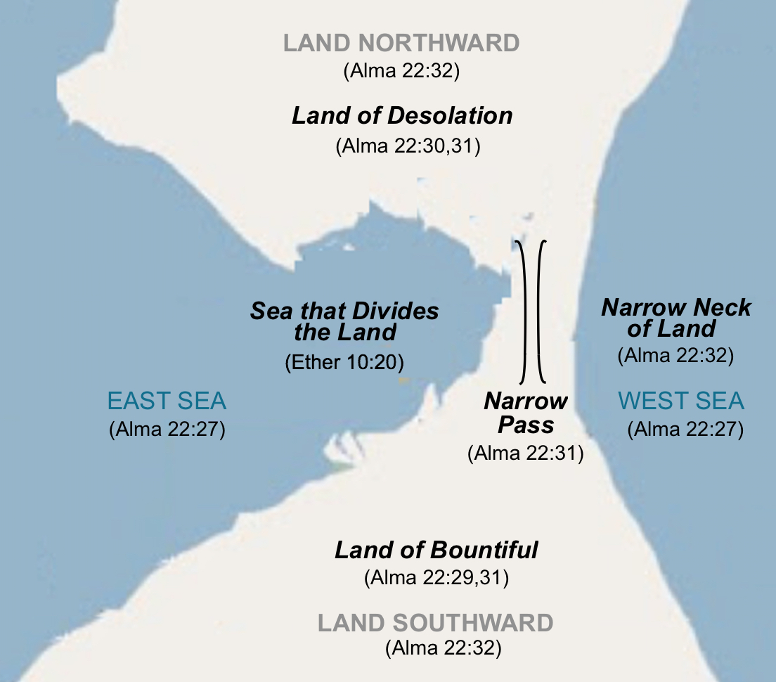
Mormon’s description of the Land of Promise showing an example of the
scriptural description of the area between the Land Southward and the Land
Northward
Mormon also tells us that this small neck can be crossed in a day and a half by a Nephite, making it about 25 to 30 miles across at the most, and from a military viewpoint, could be easily blocked because of the narrow pass or passage presented within the narrow neck that ran by the Sea on the East and the Sea on the West (Alma 50:34).
Take, as an example, the unwavering attempt by some theorists to just name an area the narrow passage, when it is not an area that can be described as a place where a defecting or escaping army can be bottled up, as a narrow Pass would do. After all, how can one army stop another army, when that second army has every opportunity to go elsewhere to get past them?

In the Great Lakes, there are at least three paths (arrows) that would
be open to an army trying to reach the land beyond the so-called “narrow pass.”
If the red arrow path was defended against, the two blue arrow paths would be
open
Take Rod Meldrum’s central U.S. area, where he creates a scenario for his Land of Promise that shows a landing along the southern coast of America, placing his Land of First Inheritance, contrary to Mormon’s description, in the south bordering on a southern coastline with the Gulf of Mexico, even though Mormon clearly states that this landing and land was in the west along the West Sea (Alma 22:28).
In so doing, he moves Nephi northward into Tennessee area for the Land of Nephi and then to the Illinois area for his Land of Zarahemla, and then erroneously he moves to the east (instead of continuing north) to Ohio for his Land of Bountiful (Alma 22:29). From there Meldrum moves to the east and north into western New York for his Land Bountiful—at no time establishing a narrow pass that could not be diverted by going around the area because of the thousands of square miles of his open land along the way.

Meldrum’s map of his movement from the Gulf of Mexico to the Lake
Ontario area, where no choke point of a narrow pass could be established that
could not be diverted by going around the area

Superior Lagoon is a marshy wetland inlet that forms the southern
coastal area of the Isthmus of Tehuantepec. Measuring from the edge of the
lagoon is misleading as to the actual width of the isthmus. Note the (Orange)
line that is some theorists’ view of the “line” Mormon mentions (Alma 22:32)
describing the defense of the Pass
A broad, plateau-like ridge, the Isthmus is 735-feet high at its highest in the 12-mile-wide Chivela Pass through the low-lying landforms of the Sierra Madre del Sur mountain, with a 90-mile wide northern side (along the shallow Bay of Campeche in the Gulf of Mexico), stretching from the Términos Lagoon to the east at the base of the Yucatán Peninsula, to southern wetlands at Veracruz on the west—an area densely covered corridor of the Zelva Zoque (Zoque Forest) a tropical forest, including the Chimalapas rain forest, the largest in Mexico, and where lagoons and swamps dot the low-lying shores along the bay in Oaxaca.
The middle area along the spine of the Isthmus includes a complex mixture of forest types, including a cloud forest above 2600 feet, and a 100-foot high canopied rain forest, as well as interior valleys, sloping to the southern side that is also filled with innumerable lagoons in the watershed system, the largest being Superior, Inferior, and Muerto.
Toward the southern end of this Coastal Plain of the Chiapas coast was the Sonconusco region, a narrow strip of land wedged between the sierra Madre and the Pacific Ocean along the Suchiate River. It is the location of Izapa, was the home of the ancient Olmec and perhaps the beginning of the Maya. It was and always has been part of the coastal plain route between Central America and Mesoamerica.
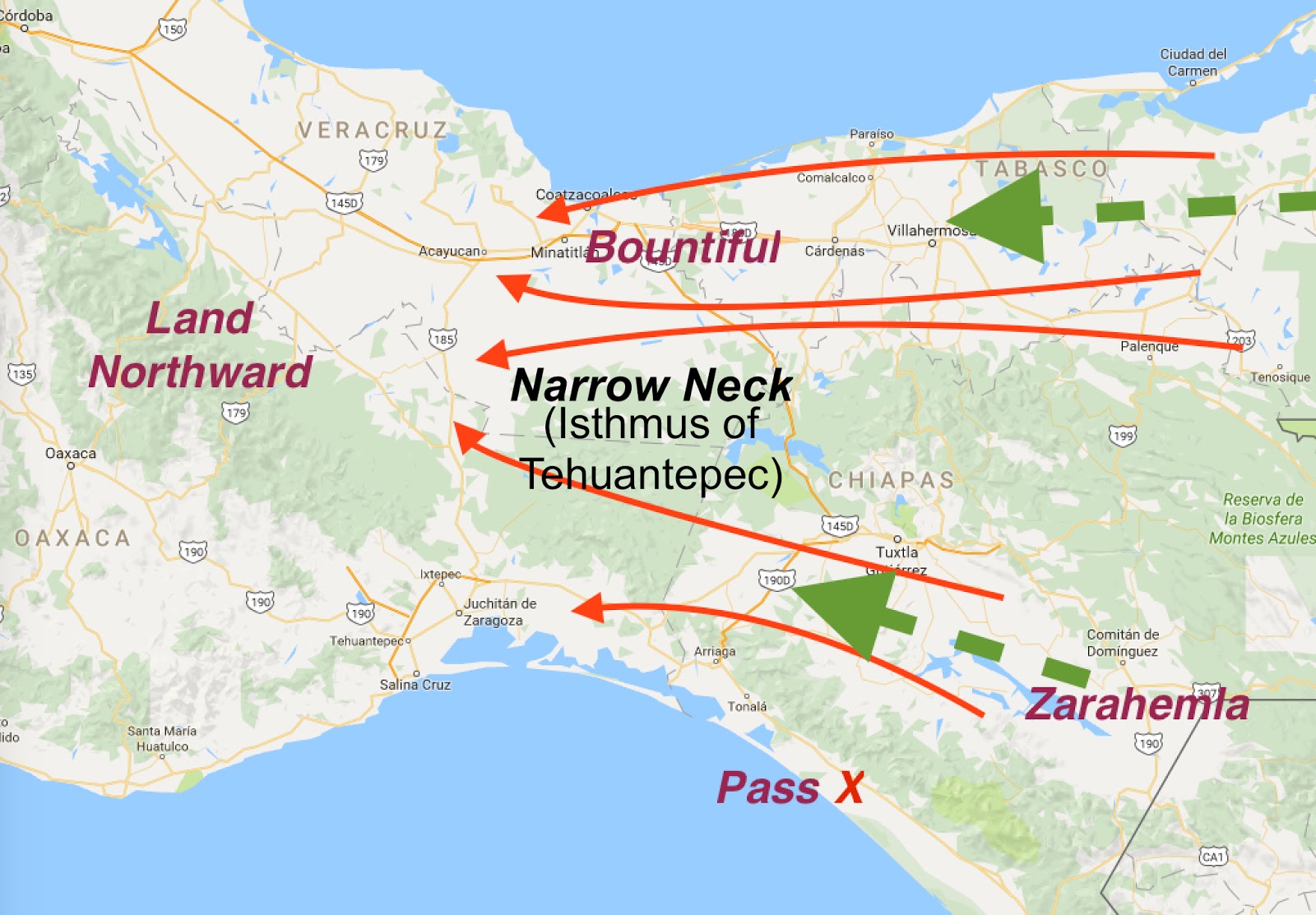
Even if this Coastal Plain passage could be blocked, it would not have
stopped an army from moving (Red Arrows) from the Land Southward to the Land
Northward on the opposite (north) side of the Isthmus, an area nearly 90 miles
wide along a relatively flat area
This so-called pass is more of a passage along Chiapas’ Pacific Coastal Plain running between Tonalá and Tapachula where numerous narrow, short, and fast moving streams run off a long wall of the Sierra Madre Mountains and head into the sea. Sandwiched between the sea and mountains is the narrow Coastal Plain covered with low deciduous scrub and a tall trees of a semideciduous forest. Toward the north of this Southeast to Northwest coastline and coastal plain is an area some Mesoamerican theorists claim is a “gate” or point where movement into Oaxaca and the numerous coastal lagoons are blocked.
Then there is W. Vincent Coon in his “How Exaggerated Settings for the Book of Mormon Came to Pass,” where he states “It is significant that LDS scripture nowhere identifies ‘the waters of the great deep’, ‘the great waters’ or ‘the many waters’ that Book of Mormon peoples voyaged across with the neighboring seas west and east of the lands of Zarahemla and Nephi.”
Evidently, he neglected to read Jacob’s statement about the Lord leading them from Jerusalem to the Land of Promise, saying: “for the Lord has made the sea our path, and we are upon an isle of the sea” (1 Nephi 10:20).
The sea our path. What sea would Meldrum think that is referring to?
And we are on an island of that sea? What sea is that, if not the ocean over which they sailed from the old world to the new?
Jacob then said, “great are the promises of the Lord unto them who are upon the isles of the sea; wherefore as it says isles, there must needs be more than this, and they are inhabited also by our brethren” (2 Nephi 10:21).
Coon also wrote: “There is absolutely no indication in scripture that this "west sea" was salt water or ocean.” Of course, one might wonder what kind ofsea they sailed over from Bountiful to the Land of Promise where Jacob says they landed, if not a salt water sea. All of this seems to be lost on Coon.
It seems, from time to time, the theorists have simply obtained some other scriptures than the ones of the Book of Mormon, which contain the “plain and simple” language of Nephi and the other prophets.


No comments:
Post a Comment