Monday, April 30, 2018

Webster vs. Oxford English Dictionaries – Part I

Does it really matter what dictionary we use in understanding the Book of Mormon translation? The most current and up-to-date dictionary available to us today is the Merriam-Webster Dictionary New Edition 2016. The most complete dictionary is the Oxford English Dictionary 2000 Third Edition, 2018 Update. English dictionaries date back to 1582 when Richard Mulcaster developed a non-alphabetical list of 8000 English words in his Elementarie, but the first purely English alphabetical dictionary was A Table Alphabeticall, written by English schoolteacher Robert Cawdrey in 1604. 
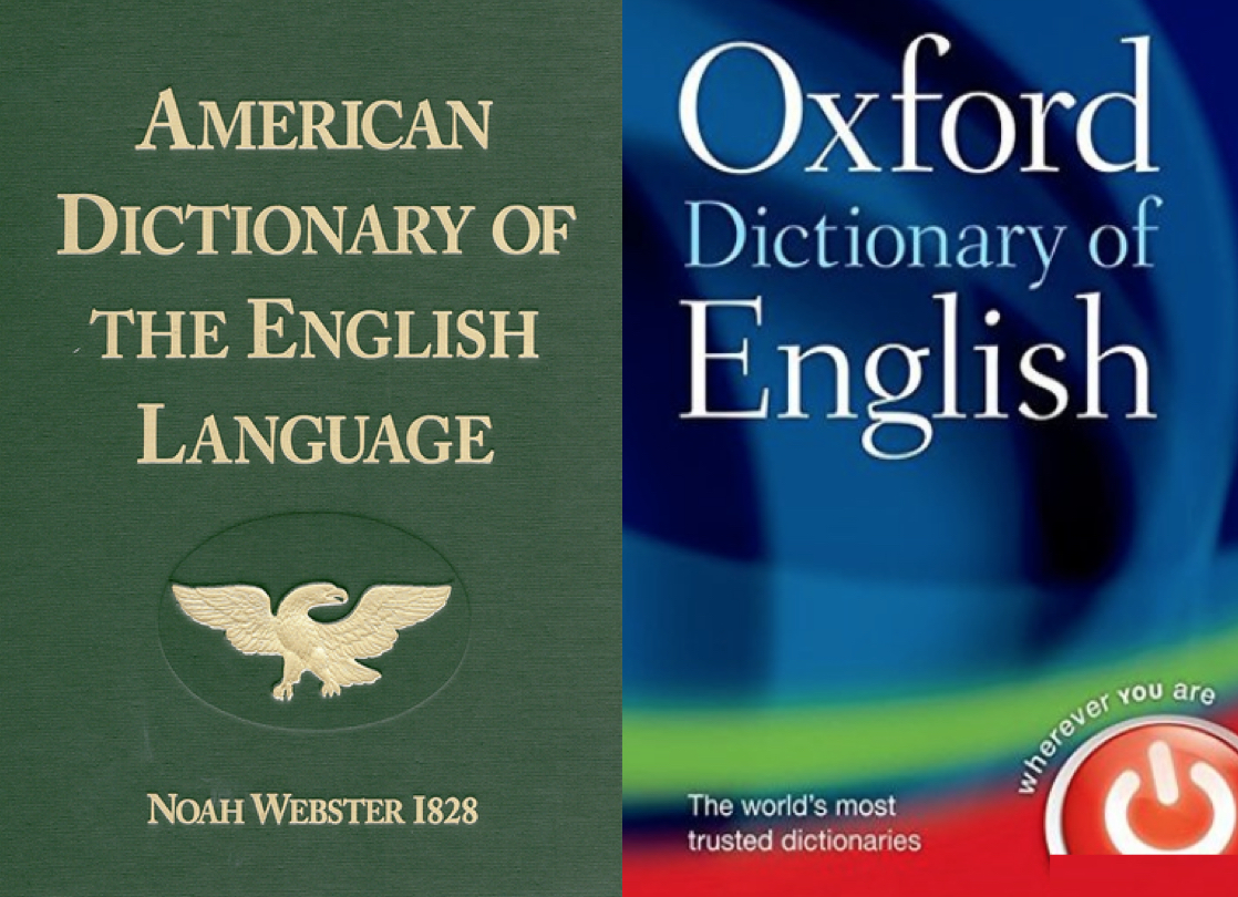
    The first American-English dictionary was published by Noah Webster in 1828, called An American Dictionary of the English Language--and after he died in 1843, George and Charles Merriam, who had founded the G&C Merriam Co. in Springfield, Massachusetts in 1828, bought the rights to An American Dictionary of the English Language from Webster's estate, and today is the direct lexicographical heir of Noah Webster. Today (since 1982) that company is known as Merriam-Webster, and is the foremost publisher of language-related reference words, as well as the longest producer of dictionaries in the world.
    It should be noted that much work has been achieved by linguists and lexicographers regarding dictionaries; however, not all dictionaries are the same. As an example, the Oxford English Dictionary contains spelling and definitions of words that are oriented toward British English,while the Webster dictionary contains spelling and definitions more oriented to American English.
    Consequently, since the Book of Mormon was published initially for Americans, and even more specifically those living in the New England area where the Church was first organized, American-English would seem to be the predominant meaning of words used by Joseph Smith in his translation,who himself, like Noah Webster, was from New England.
    However, in a never-ending attempt at understanding the interpretation of the scriptural record in Joseph Smith’s translation, various linguists, writers, and theorists make unusual and sometimes downright unbelievable claims. As an example, on Kirk Magleby’s Book of Mormon Resources website, in an article entitled OED on Necks of Land, the author quotes heavily from Royal Skousen’s "The Original Language of the Book of Mormon: Upstate New York Dialect, King James English, or Hebrew?" in Journal of Book of Mormon Studies (3.1). 
    Skousen, our readers might recall, a Professor of Linguistics and English Language at BYU, has been for some time a believer that the Book of Mormon has many errors in it and should be updated and the language considerably changed or altered to fit his findings according to his Analysis of Textual Variants of the book of Mormon (a Six-Volume Set, Interpreter Foundation, 2017). For background on Skousen’s project and the many errors Skousen makes, see our 11-part Series on “The Critical Text Project or Webster’s 1828 Dictionary: An Interesting Comparison” (appeared between Saturday, December 5, 2015, and Tuesday, December 15, 2015, in this blog).
    In any event, the website article is fraught with erroneous conclusions and misleading information regarding the scriptural record and its interpretation.
According to the article, which is supportive of the OED (Oxford English Dictionary) over the 1828 American Dictionary of the English Language, which we use throughout our blog articles when defining words Joseph Smith used in his interpretation, states: “The indispensable dictionary for exegesis of Mormon's and Moroni's abridgments can only be the incomparable Oxford English Dictionary commonly called the OED. Textual scholars such as Royal Skousen and Stanford Carmack use the OED extensively.” Now “exegesis” means the “critical explanation or interpretation (explanation and meaning) of a text, especially of scripture,” so the article as well as Skousan and Carmack, claim that any question about the meaning of a word in the Book of Mormon should be referred to the Oxford Dictionary for understanding.
    First of all, by way of background, Magleby introduces a reference to an earlier article he wrote entitled “Early Modern English” in which he begins by saying that 450 A.D. was the beginning of Old English, which continued until 1100-1170 A.D., when Middle English began, continuing until 1300 A.D., followed by Late Middle English through 1470-1500 A.D., which was replaced by Early Modern English until 1670-1700 A.D. (possibly 1800 A.D.) This was finally replaced by “Modern English aka Late Modern English which has become Earth's lingua franca.”
    He then goes on to state that in 1611 the first edition of the King James Version of the Bible was published in Early Modern English, with predecessors including the Tyndale New Testament in 1526 and the Coverdale Bible in 1525. In 1755 Samuel Johnson's Dictionary of the English Language helped standardize the Modern English we use today. And that the first edition of the monumental Oxford English Dictionary was published in 1928 in ten bound volumes. The most cited work in the OED: various editions of the Bible. The most cited author: William Shakespea/re. Shakespeare's most cited play: Hamlet
In the early 1800s, American life was centered around the home, church and school and established on Biblical and patriotic basis

On the other hand, Noah Webster's work begins with an explanation of the reasons why he wrote his dictionary, stating: “it was produced during the years when the American home, church and school were established upon a Biblical and patriotic basis, and contains the greatest number of Biblical definitions given in any secular volume, since he considered “education useless without the Bible,” saying “the Christian religion is the most important and one of the first things in which all children under a free government, ought to be instructed.”
    Webster opposed Horace Mann’s progressive reduction of the meaning of religion and the constitution in his educational promotions. It was Horace Mann who, in the 1840s, removed the Bible and its sacred purpose from the schools, not the U.S. Supreme Court in the 1960s. Webster was opposed to this European pilgrimage of Mann and his contemporaries planting the alien seeds of foreign ideologies and philosophies of education on American soil. Webster believed in the American independence from European “maxims of government” and labored extensively to eliminate them from American schools and philosophy—an idea that stemmed from the New England mindset of Americans, of which the Smith family was part.
    Webster’s plea in his 1828 dictionary stated: “This country must be as distinguished by the superiority of her literary improvements, as she is already by the liberality of her civil and ecclesiastical constitutions. Europe is grown old in folly corruption and tyranny—in that country laws are perverted, manners are licentious, literature is declining and human nature debased. For America in her infancy to adopt the present maxims of the old world, would be to stamp the wrinkles of decrepid age upon the bloom of youth and to plant the seeds of decay in a vigorous constitution.”
    Webster was adamant about not repeating the mistakes of Europe in the development of America. In that effort, he was also adamant about having a language that represented America and how it was then being spoken in New England (by the Smith family and all New Englanders), and to alter the words to the American vocabulary and not that of England. This was such a noticeable change from the English spoken and defined in Europe, that he developed his dictionary, which was explicit on the spelling and pronunciation of words, as well as their meaning. Webster was aggravated by the introduction of English understanding of words into the American lexicon.
Webster’s “Speller,” “Reader,” and “Grammar” books in all American schools in early 1800s

From the age of 25 and for the next 60 years, he developed and produced a repository of school texts unequaled for its consistency in teaching the precepts of American spelling, pronunciation and grammar, American history, civics, geography and literature. The publication of Webster’s “Speller” in 1783 was followed with a “Grammar” in 1784, and a “Reader” in 1785. These were Parts I, II, and III of “A Grammatical Institute of the English Language,” whose title was suggested by President Ezra Stiles of Yale College, and were republished again and again and became the basis of an American system of education and their influence grew with the history of the young republic.
    In all of this, Noah Webster was not so much in creating something different, but in preserving the American method and use of the English language that existed in the area of American concentration, that is, in the New England area of the late 1700s and early 1800s.
    Webster was specifically displeased with the English language attempt to avert the meaning of the new American Republic to a “democracy” in which, as the eminent British scientist Joseph Priestley put it in 1800, meant that only Democrats were Americans, and any other political ideology was subversive and against the American Constitution, which he called the American Democracy. English, as understood in Britain, had very different meanings and interpretation of government and government philosophy than that of America and Americans. Webster wanted to preserve those differences, since they were the very core and basis of the Constitution and the American government. His dictionary accomplished that and numerous other Americanisms that were missing from the English dictionaries, including the Oxford English Dictionary.
    To say, as Magleby and others do, that Joseph Smith’s writings reflect better the OED than the Webster interpretations of language is far from accurate, and extremely misleading if not downright disingenuous. Noah Webster grew up 90 miles from where Joseph Smith grew up. They knew and used the same language and the same interpretation of that language. The 1828 American Dictionary of the English Language contained not only the language Joseph Smith knew and used, but it was also the dictionary he chose to use for the School of the Prophets classes in the teaching of the brethren about the gospel and its meaning.
    The fact that Magleby claims: “The indispensable dictionary for exegesis of Mormon's and Moroni's abridgments can only be the incomparable Oxford English Dictionary commonly called the OED. Textual scholars such as Royal Skousen and Stanford Carmack use the OED extensively,” should suggest to us that Magleby and the others who rely on the OED are simply out of touch with the reality of Joseph Smith and his times in New England America.
    It is also interesting that Noah Webster claims in his introduction to his dictionary that he felt the Spirit of God prompting him in his work, and the fact that the dictionary appeared just two years prior to the publication of the Book of Mormon ought to suggest to us that the Lord had his hand in the matter.
(See the next post, “Webster vs. Oxford English Dictionaries – Part II,” regarding the difference between Britain English as found in the Oxford English Dictionary, or American English as found in Webster’s 1828 American Dictionary of the English Language)

Sunday, April 29, 2018

The Interesting and Long-Lasting Results of Fortún Ximénez’ Voyage

Over the past several years we have received copies of maps and internet references to maps showing various but erroneous points regarding the early Americas, especially what is now North America, in an attempt to “prove” a particular point of view. Many of these maps were inaccurate, especially regarding the areas around the Great Lakes and westward. 
    A curious reality about ancient maps is that they were often wrong in many and certain details—sometimes very important details. We need to be very careful when dealing with ancient maps, or their reproductions, that we understand the need for verification of other maps of the time, not just rely upon one because it states what we want it to show.
    As an example, early Spanish maps of California showed it as an elongated island. The early explorers in the New World thought it was an island because of the land mass of what is now called Baja California and sea area called the Gulf of California (Sea of Cortez).
Ximénez left Manzanillo and headed north along the coast, later discovering the Gulf of California and what is now Baja California, thinking it was an island 

As is stated in history: “The Island of California refers to a long-held Spanish misconception, dating from the 16th century when Hernán Cortés sent Fortún Ximénez, a Spanish sailor and pilot of the ship “Concepción,” which was captained by Diego de Becerna, on November 30, 1533, to travel north along the coast of New Spain (Nueva España)—leaving today’s Manzanillo, Colima, Mexico and heading north—in search of two ships that had been lost without a trace on a similar voyage the previous year. The previous voyages had been in search of the "Strait of Anián" (the western end of the much-hoped-for Northwest Passage and the Island of California, which was named for the romance novel, Las sergas de Esplandián (The Adventures of Esplandián), previously published in Spain (1510) and popular among the conquistadors. The novel mentions a fictional island terrestrial paradise named California, inhabited only by black women, and ruled by Queen Calafia. In fact, the novel itself was a sequel to Montalvo's more famous tales of Amadis de Gaula (1508), father of Esplandián, in which he described the island in this passage:
    “Know, that on the right hand of the Indies there is an island called California very close to the side of the Terrestrial Paradise; and it is peopled by black women, without any man among them, for they live in the manner of Amazons.”
During the voyage, Ximénez led a revolt in which the captain was killed. The mutineers then landed near present-day La Paz, on the southern tip of the Baja California Peninsula, which the mutineers believed to be the Island of California, which was rumored to be ruled by Amazon women, and though a peninsula in fact, these mutineers named it California.
    Ximénez was killed in a clash with the local natives, and the survivors returned to New Spain with the story of having black pearls, which prompted further exploration of the "Island" of Santa Cruz, as Cortés named the peninsula. Later, Francisco de Ulloa explored the peninsula, mistook it for an island, and perpetuated the myth, having discovered only the southern portion of the peninsula, and reported that California was not part of mainland North America but rather a large island separated from the continent by a strait now known as the Gulf of California (Sea of Cortez).
    The stories of the earlier survivors prompted several follow-up expeditions by Cortés in the following years, which resulted in very short-lived pearl fisheries. It is one of the most famous cartographic errors in history, it was propagated on many maps during the 17th and 18th centuries, despite mounting contradictory evidence from various explorers.”
In another incidence, Juan de Fuca, in 1592, exploring the western coast of North America, claimed to have found a large opening that possibly connected to the Atlantic Ocean—the legendary Northwest Passage. He found a large strait, with a large island at its mouth, at around 47° north latitude, referred to as the Strait of Juan de Fuca, which is the southern tip of the large island now called Vancouver Island. However, explorers and mapmakers of the 17th century confused the strait with the northern terminus of the Gulf of California and the terminus of the Colorado River, leading to further exploration, and maps showing considerable error along the west coast of North America.
In addition, though by the 1600s California was corrected and shown to be connected to the mainland on maps, the reemergence of the Island of California reappeared on a copper-engraved map by Michiel Colijn of Amsterdam, believed to have been taken from a map that accompanied Friar Antonio de la Ascension's account of the area written in October 1620 for the Council of the Indies and the King of Spain. For some reason, it became the standard for many later maps throughout the 17th century and intermittently into the 18th century.
    However, the Jesuit missionary and cartographer Eusebio Francisco Kino around 1700 revived the fact that Baja California was a peninsula. While studying in Europe, Kino had accepted the insularity of California, but when he reached Mexico he began to have doubts. He made a series of overland expeditions from northern Sonora to areas within or near the Colorado River's delta in 1698–1706, in part to provide a practical route between the Jesuits' missions in Sonoran and Baja California but also to resolve the geographical question.
    Kino satisfied himself that a land connection must exist, and the 18th century Jesuits generally followed his example. The first report of Kino's discovery and his map from 1701 showing California as a peninsula were sent to Europe by Marcus Antonius a Jesuit missionary from Kamna Gorica (Duchy of Carniola, now Slovenia). In a June 1701 letter, he wrote about that to his friend Philippus Alberth in Vienna and thus acted as an important intermediary in the dissemination of this knowledge. However, Juan Mateo Manje, a military companion on several of Kino's treks, expressed skepticism; European cartographers remained divided on the question.
Jesuit missionary-explorers in Baja California who attempted to lay the issue finally to rest included Juan de Ugarte (1721), Ferdinand Konščak (1746), and Wenceslaus Linck (1766). The matter was settled beyond all dispute when the expeditions of Juan Bautista de Anza traveled between Sonora and the west coast of California in the period 1774–1776. However, for over 275 years hundreds of maps circulated throughout Europe, Asia, and New Spain showing California as an island, and in the last 100 years, despite factual knowledge it was on the mainlan.
Sebastian Munster’s map of the New World, first published in 1540

All of this should show us that relying on ancient maps alone, especially in the Western Hemisphere because of its slow development during map making stages when this fourth part of the world was being discovered, without additional information to cross-check, at best, is open to question and certainly questionable to use for absolute proof as many Theorists do in trying to pinpoint the Land of Promise.

Saturday, April 28, 2018

Theorist’s View of Mississippi River as the West Sea

One of the many theorists who insist on placing a map of Book of Mormon Lands within North America and the U.S. heartland, is Jonathan Neville, who seems to ignore important issues regarding the scriptural record. Take, for instance, his labeling and placing of the West Sea as the Mississippi River.
    About his book, Moroni’s America, Tim Ballard, author of The Lincoln Hypothesis and The American Covenant, writes: “Finally, a complete, honest and faithful look at Book of Mormon geography that deals with all the tough questions…a definite game changer.” Yet, the really tough questions, at least for Neville, is how on earth is the Mississippi to be considered the West Sea? After all, the West Sea was not a river, but the border of the Land of Promise in the west, it was part of that sea that nearly surrounded the Land of Nephi and the Land of Zarahemla (Alma 22:32), and from which the entire Land of Nephi stretched, from the West Sea to the East Sea (Alma 22:27); it was the western boundary of the narrow strip of wilderness (Alma 22:27); and it was the sea into which Hagoth launched his “exceedingly large ships” (Alma 63:5).
The Mississippi in 1782, a narrow and shallow river, requiring flat-bottomed boats and paddle wheelers to navigate

Yet, according to all scientists on the matter, including Potamologists within the field of Geology, even though a river is obviously formed when water streams and tributaries join together to grow bigger and bigger, as more and more streams and tributaries combine along the route, according to the studies in Potamology, which is the study of rivers, the ancient Mississippi was never anything but a rather narrow river, stretching at most a mile or so wide, though its course was always moving from geologic activity.
    In fact, the Mississippi is regarded as being like a shifting snake, twisting to find its easiest way down to the Gulf. These shifts, which have occurred about every thousand years or so, especially in the lower parts of the river, do so through a process known as Avulsion, or delta switching. This occurs when the river flow is slow, the sedimentation clogs the river channel and it eventually finds another channel.
    It should be kept in mind that the reason sediment builds up that changes the flow of a river is that the river is so shallow, that as sediment (silt, sand and clay that falls out of the current and settles on the bottom of a river) flows downriver, its shallow bottom becomes even more shallow as more and more sediment falls to the bottom. This, in turn, causes shifts in the direction of the river’s flow until enough sediment builds up, the river course is changed completely.
    In fact, the extreme shallowness of the river forced a unique ship construction to use the river in the early days of the river’s development and that was the extremely shallow draft of the Mississippi riverboats, with their flat bottoms, and the pilot house so high up and so far forward to allow the Captain to see the river far enough forward to steer his vessel around sandbars and other debris in the river. For theorists to think that Lehi sailed up that river, with its shallow depth and numerous rapids is simply without merit and foolish in the light of the reality of the river.
    In addition, this build-up of deposition from the river resulted in the formation of an individual deltaic lobe that pushed out into the sea. An example of a deltaic lobe is the bird's-foot delta of the Mississippi; however, this process is by no means ‘historic’ (i.e. ‘over’) – from the 1950s onward, the U.S. government has worked on the Old River Control Structure, meant to prevent the Mississippi from switching to the Atchafalaya River channel.
    Upon first discovery, Hernando de Soto, called it the Rio de Espiritu Santo (‘Holy Ghost River’) and later called by French explorers Cavelier de la Salle and de Tonty, the Rivière Colbert, because of its ghost-like, changing beds.
The Fisk map of all the various channels or river beds the Mississippi River has had over its entire history. The river never widened and never deepened, only changed its course because of avulsion

In a report for the Army Corps of Engineers, Harold Norman Fisk’s maps of the historical traces of the Mississippi River are an amazing surprise, showing the river’s history since ancient times in fifteen maps, stretching from southern Illinois to southern Louisiana.  At no time was the river larger than its present size—only that it continued to move about, creating muddy sediment beds many miles wide across a large swatch of land. At no time would the water course have been considered a deep river, let alone a sea.
    Fisk, who held a Geology Ph.D from the University of Cincinnati, served for 16 years as a consultant to the Mississippi River Commission (1948–1964), joined the Louisiana Geological Survey (LGS) in Baton Rouge, Louisiana, where he conducted research on the geology of 750 square miles of the Lower Mississippi Valley in 1940, showing abandoned courses of the Mississippi. In June 1941 he conducted a geological investigation of the LMV over a period of 2 years with a staff of four Ph.D geologists studying the ancient beds. The success of the original 2-year project was so great that Fisk and his staff continued to study LMV for five more years.
    He also served as Professor of Geology at Louisiana State University, leaving in 1948 to become Chief of the Geologic Research Section of the Humble Oil and Refining Company in Houston, Texas, who permitted Fisk to continue as consultant to MRC and the U.S. Army Engineer Waterways Experiment Station at no cost to MRC. After attaining international recognition, Fisk died in Houston at the age of 56 in 1964. Rufus J. LeBlanc in Engineering Geology stated: “The world lost one of its finest geologists.”
Top: The Mississippi, as shown passing Memphis, Tennessee, in 1740, is and always has been a narrow and shallow, slow-moving river; Bottom: Mississippi River passing Memphis  in 2000

Fisk's work provided a three-dimensional pattern of occurrence and composition of sediments in the alluvial valley and deltaic plain of the lower Mississippi River. He also interpreted the processes by which the sediments were deposited and the relevance of tectonism in their history. These data provide site characterizations that are basic for all major categories of engineering.
    Famed engineer in the U.S. Army Corps of Engineers, Ellis L. Krinitzsky, speaking of Fisk’s contributions, said, “His work has found applications in better methods for control of the river, stabilizing its banks, locating sources of aggregate for concrete, management of groundwater, maintenance of wetlands, and generally for more reliable, timely and economical evaluations in selecting optimum site locations and determining foundation conditions.”
    Since then, work in the Lower Mississippi Valley (LMV) has expanded enormously and continues to be greatly indebted to formative interpretations by Fisk.
    The point of all of this is simply that according to Fisk, whose credentials are beyond reproof, the Mississippi was not a lake, sea, or huge and vast river or body of water. It was always a river, much like it is today, nor was it much deeper at any point, which is why its bed changed so often. In fact, at its beginning at Lake Itasca, it is between 20 and 30 feet wide, passes quickly through the 11-mile wide Lake Winnibigoshish (“filthy water”) near Bena, in north central Minnesota in the Chippewa National Forest, and is about two miles wide at Lake Pepin, just south of Minneapolis. At the confluence of the Missouri River, it is almost a mile wide, in Iowa, because of the dams and locks, it is three miles wide, but anciently would have been far less.
    Its deepest point is between Governor Nicholis Wharf and Algiers Point in New Orleans because of Corps of Engineers dredging, which is a continual requirement since the river carries an average of 436,000 tons of sediment each day. Over the course of a year, it moves an average of 159 million tons of sediment. Averages have ranged from 1,576,000 tons per day in 1951 to 219,000 in 1988.
Red Circle: The Sea East; Red Arrow: Width of the Land of Nephi

Yet, Neville insists on claiming his own map fits the scriptural record, and Tim Ballard (see earlier) claims Neville “deals with all the tough questions,” but the very simple statement by Mormon, is completely ignored in his map. After all, Mormon is not vague when he says: “the king sent a proclamation throughout all the land, amongst all his people who were in all his land, who were in all the regions round about, which was bordering even to the sea, on the east and on the west” (Alma 22:27). And no matter how one may argue the matter, the Susquehanna River is not the Sea East, besides, Neville’s map shows his East Sea several miles north of the eastern boundary of the Land of Nephi.
    The point is, looking at a map and placing locations upon it that seem to work out is not the same as operating in the real world where ships have to go where they are able, or were able, in order to reach certain locations. Shallow rivers do not allow for deep-sea ocean vessels, like the one Nephi built and launched into the ocean to sail thousands of miles across oceans to the Western Hemisphere from the Arabian Peninsula. In addition, rivers that appear on maps do not always go where one thinks they do. The Mississippi as well as the St. Lawrence rivers were simply not navigable very far from the ocean, yet unlearned theorists continue to claim Lehi sailed up these rivers to the interior of the Heartland or to the Great Lakes—both of which would have been impossible in 600 B.C. by the type of ship Nephi built to carry him across the deep oceans.
    Saying Lehi sailed somewhere is not the same as Lehi being able to sail there. And placing lands in an area and labeling them is not the same as land locations that agree with the scriptural record and Mormon’s descriptions. Claiming Lehi and Nephi did something that is provably impossible for the time is not only inaccurate and misleading, it does a considerable disservice to the reputation of the Book of Mormon and the credibility of the scriptural record.
    If one is going to make claims of what the Book of Mormon states and means, one has to understand the meaning of ancient Hebrew that would have been used by the Hebrew-speaking and Hebrew-writing Nephi and Mormon in their writing as well as understand the language of Joseph Smith’s day in 1829 when he translated these ancient writings. Using a modern Oxford dictionary developed by British-English-speaking people of today to define words written in 1829 by a New England farm boy is hardly consistent with the language he would have known in 1829 New England America. And looking at a modern map is again inconsistent with the geography of lands beginning 2600 years ago (from 600 B.C. to 400 A.D.)
    As an example, numerous theorists beginning with Hugh Nibley onward have made claims that the word “wilderness,” which appears hundreds of times in the Book of Mormon, meant “desert” or it meant “mountains,” however, in 1829 in Joseph Smith’s day, it meant “a tract of land or region uncultivated and uninhabited by human beings,” which means any type of land that was unoccupied.
The Wilderness of Judea containing miles and miles of desolate land with deep ravines, rocky terrain, barren grades and stony slopes with scant vegetation

While it is true that in the Bible, it generally applied to deserts, such as the Judean Wilderness, or the Rub ‘al Khali (Empty Quarter), the largest sand desert in the world, which Lehi crossed when leaving the borders of the Red Sea and turning “nearly eastward” (1 Nephi 17:1), it would not necessarily have meant “desert” in the Land of Promise—but at all times it meant “an unoccupied area of land,” that was “uncultivated and uninhabited by human beings.” Today, it generally means a wide barren plain, wasteland, bush or bush country, or wild country.
Nez Perce Clearwater National Forest in Idaho—a wilderness preserve under the National Wilderness Preservation Act
  
In the U.S. it specifically means a forest, though the National Wilderness Preservation Act in the U.S. incorporates thousands of areas, such as the Cedar Mountain Wilderness south of the Great Salt Lake or the Cottonwood Forest Wilderness in Zion National Park, Nez Perce National Forest, Bitterroot National Forest, Clearwater National Forest, and the Wasatch National Forest in Utah and Idaho.

Friday, April 27, 2018

The Planting Climate – Why it Matters

 "And it came to pass that we did begin to till the earth, and we began to plant seeds;l yea,we did put all our seeds into the earth, which we had brought from the land of Jerusalem. And it came to pass that they did grow exceedingly; wherefore, we were blessed in abundance" (1 Nephi 18:24). Since Nephi took the moment to write this down on his "sacred plates," it would seem he had a purpose in doing so. Certainly, that a new crop in a new area was important to ancient man, especially upon landing in an unfamiliar and undeveloped area. So perhaps we ought to consider its importance as well.
    Most people know and understand that plants do better under certain circumstances, especially before modern technical planting assistance and methods were developed.
Modern technical planting aids and techniques that have improved crop production and climatic conditions

In addition are the modern use of microbes; bacteria; fungi' nematodes; and even viruses that aid in plant growth and production, as well as evolving molecular breeding for crop improvement. Obviously, scattering seeds across the top of the soil when planting wildflowers is sufficient, but not so when planting for vegetables. A much greater knowledge is available and required today. We now understand the importance of growing seeds in climate areas that are conducive to the type of seeds being planted. We even know today, that charting seeds where they were grown in the garden the previous year is important, as is knowing how well certain types of seeds did in the previous planting seasons. We understand much better today about plant size and yield, and how to mix plants together to provide plant-growing nutrients, phosphorous and potassium replacement, and shade automatically occurs from planting companion plant combinations. This includes the unlocking of phosphorus, nitrogen and sulfur in the soil and siphoning it back to the  host plant, like an I.V. of liquid fertilizer.
    Most importantly, how we understand planting seeds in appropriate climates to maximize harvests and production. Yet, despite all we know and how much better we can now learn to maximize planting and the results, there are those who, for some reason, do not think any of this matters. Take, for example and numerous comments we receive about the idea of climate, especially a Mediterranean Climate for Lehi’s seeds, brought from the Mediterranean Climate of Jerusalem, matters little or not at all. In fact, the lack of understanding about climates is at the basis of numerous criticism of some of our articles. Take the following:
    Comment: "As for climate you need to look at climates at the time Lehi lived. Fair winds." Miles M.
    Response: The idea that climate changes like the weather is inaccurate and ill-founded. In fact, geographers recognize a number of factors that affect a region’s climate:

These factors are long term and seldom change, even a little—latitude, elevation, temperature, precipitation  and atmospheric circulation are constants and do not change; short of calamitous and wide-spread events, a regions’ proximity to water, mountains and other features do not change 

    Together, these factors control the range of temperatures and the amount of rain and/or snow each region receives through the year. These factors control climate, and in turn, climate controls ecology—the types of native plants and animals that live in a region.
    This, among many other factors, led Russian German climatologist Wladimir Köppen to develop the now famous Köppen Climate Classification system that was based on long-term records of temperature and precipitation that revealed climate patterns across continents, as well as the range of native vegetation that thrives in a place, since plant species can only thrive within a specific range of temperature and moisture conditions.
    Köppen found, as most people know today, that climates do not vary much and exist over large areas. As an example, it is common knowledge that areas with moderate to high temperatures and abundant rainfall throughout the year are heavily forested (unless humans have cleared the land for agriculture!). And regions with not much rainfall and scarce vegetation are called deserts, or arid regions. In addition, soil properties like its fertility affect the vegetation. Highly fertilized, or humus soil is good for agriculture because it has abundant nutrients due to the presence of organic matter. However loose soil similar to sands is not suitable for plant growth. This is also true with concrete soils.
    In addition, vegetation regions can be divided into five major types: forest, grassland, tundra, desert, and ice sheet. Climate, soil, the ability of soil to hold water, and the slope, or angle, of the land all determine what types of plants will grow in a particular region. Natural vegetation in an area, meaning plants that have not been grown by humans) gets whatever it needs from its natural environment.
Thus, the biogeochemical cycles of natural vegetation, water, carbon, and nitrogen, converts solar energy into biomass and forms the base of all food chains. A desert is obviously a barren area of landscape where little precipitation occurs and consequently living conditions are hostile for plant and animal life—such growth is often limited to: tumbleweed, Prickly Pear, Cacti, Saguaro Cactus, Mexican Poppies, Weathered Trees, succulents (agave, aloe, elephant trees, and many euphorbias) and Wildflowers. 
    The lack of vegetation exposes the unprotected surface of the ground to the processes of denudation, with about one third of the land surface of the world is arid or semi-arid. 
    In Köppen, published the first version of his map of climatic zones in which the seasonal temperature ranges were plotted. It led to the development of the Köppen Climate Classification system around 1900, which is based on the major climatic types, which are based on patterns of average precipitation, average temperature, and natural vegetation. Köppen kept improving this system classification for the rest of his life.
    The full version of his system appeared first in 1918; after several modifications, the final version was published in 1936. It is one of the most widely used climate classification systems in the world. It was first published by the Russian geographer, meteorologist, climatologist, botanist and paleoclimatology after years of studies and, after some modifications, and is still commonly used today. Towards the end of his life, Köppen cooperated with the German climatologist Rudolf Geiger to produce a five-volume work, Handbuch der Klimatologie (Handbook of Climatology). It was never completed, but several parts, three of them by Köppen, were published. After Köppen's death in 1940, Geiger continued to work on modifications to the climate classification system.
    This system, is made up of six major groups: A (tropical), B (dry), C (Moist Sub-tropical), D (Moist Mid-latitude), E (polar), and F (highland areas) with each category further sub-divided into sub-categories based on the annual and monthly averages of temperature and precipitation, resulting in 24 sub-categories. These major categories are given a Capital Letter in a three-letter code. The second letter indicates the seasonal precipitation type, while the third letter indicates the level of heat, so that a single climate group can have as many as six variances or sub-categories, within 12 Climate Regions:
The area of interest in this article is #5: Subtropical dry summer climates, also called a Mediterranean Climate. These subtropical dry summer climates feature warm to hot, dry summers and mild, rainy winters, and occur on the west side of continents roughly between 30 degrees and 45 degrees latitude. The closer to the coast the area is, the more moderate the temperatures and the less the contrast between summer and winter temperatures.
    The Köppen system was revised in 1960 and again in 1980, as more meteorological information became available. But the point is, the system is based on long-term data collected over lifetimes of work by several people and represents as stable and accurate an understanding of climate as is currently available.
    While we do not have climate data at the time Lehi lived in the area of the Land of Promise, we do have climate data of the Palestinian area as recorded in numerous ways over the last three thousand years. We know, as a fact, that the area of the Mediterranean, that is the surrounding coastal region of the Mediterranean Sea is the best recorded date of climate anywhere in the world. The Mediterranean Climate is given a Csa, Csb and Csc classification, and two (Dsa and Dsb) Mediterranean-influenced climates classifications.
    The climate classification for where Lehi landed in Chile is classified as Csb, which is a subtype of Csa—the Mediterranean Climate in which Jerusalem is classified. Thus, the seeds Lehi brought from Jerusalem would have grown exceedingly well where he planted them in the Land of Promise, being in Chile.
The Köppen Climate Control System showing how various climates exist in the Western Hemisphere. Note that only Chile has a Mediterranean Climate, matching that of Jerusalem, in South America, and only areas of California have such a climate. Neither the Great Lakes or Heartland have matching climates, nor does Mesoamerica 

On the other hand, in Mesoamerica, particularly around the area of theorists claims for Lehi's first landing, City of Nephi and Zarahemla, the climate is Cwb, an oceanic Subtropical Highland Climate, influenced by Monsoon temperate oceanic climate, and not conducive to seeds from Jerusalem, i.e., they would not have grown there initially. The Great Lakes area is Dfa and Dfb, while the Heartland is either Dfa (humid continental climate) in the northern part or Cfa (temperate rainy climate) in the southern part and again, not compatible with seeds from Jerusalem in 600 BC.
    It should also be understood that seeds were always planted in the same climatic conditions as the plants that provided them. Seeds were never transported very far away from where they had been grown. Farmers in antiquity rarely moved about, and if they did to any extent, they were forced to purchase new seeds if the area was populated, or to nurse seeds through two or three growing periods to adapt a seed from one climate to another—a time consuming and difficult to sustain process that had to be supplemented with hunting and fishing for current and short term sustenance.
    While this is a well-known fact among farmers and those who depended upon planning seeds for their survival, modern man seems completely oblivious to the fact. However, cactus does not grow in the artic, Alpine plants do not grow in the desert, but in an alpine climate, which occurs at high elevation and above the tree line—this refers to the zone of vegetation between the altitudinal limit for tree growth and the nival zone (region of perpetual snow).
    Alpine plants are not a single taxon, rather, many different plant species live in the alpine environment, and include perennial grasses, sedges, forbs, cushion plants, mosses, and lichens, as well as Phacelia, Bear Grass, Bristlecone Pine, Moss Campion, Polylepis Forest, Pygmy Bitterroot, and Wild Potato. However, alpine plants do not grow in deserts.
    Again, and this cannot be over-emphasized—in 600 B.C., when planting and harvesting was accomplished with primitive materials, fertilizers, and farming aids, seeds had to be planted in like or at least very similar climatic conditions, soils, temperatures, and precipitation areas. When Nephi tells us his seeds, brought from Jerusalem grew exceedingly and produced an abundant crop, we need to understand that in his time, that could only mean he planted his Mediterranean seeds in a like climate, or another Mediterranean climate.
    The only Mediterranean climates in the entire Western Hemisphere are either in the area of Coquimbo/La Serena, Chile, or in central and southern California. They are not found, and nothing even similar is found, in Mesoamerica or Central America, or in the Heartland or eastern or southern United States—which is the reason so many theorists want to ignore this critical issue because it simply does not meet their model and narrative.

Thursday, April 26, 2018

Another Critique Regarding Joseph’s Translation

In answer to a critique on one of our articles regarding Joseph Smith’s translation of names he did not know about, one reader’s critique of him not naming the animals stems from the method in which Joseph translated. Following is his series of comments and our responses:

Comment: “The assumption that those two oddly named animals were the Alpaca and the Llama make some very liberal assumptions. First, you assumes that Joseph Smith saw in vision the words he was translating. This doesn't seem to be the case. In most instances we learn that he saw words.” Riingram 23
    Response: First of all, there seem to be different terminologies used by different scribes and people, and at different times by Joseph Smith himself, some of these terms were “interpreters,” “Spectacles,” "Urim and Thummim," and "Seer Stone." Those who saw the interpreters described them as a clear pair of stones bound together with a metal rim. The Book of Mormon referred to this instrument, together with its breastplate, as a device “kept and preserved by the hand of the Lord” and “handed down from generation to generation, for the purpose of interpreting languages.”
Left: Hebrew High Priest wearing a Urim and Thummim within the breastplate; Top Center: The gold breastplate of judgment hung from chains of pure gold and in the breastplate was the Urim and Thummim; Bottom Center: Artist depiction of the Urim and Thummim Joseph Smith had; Top Right: Artist Depiction of Joseph wearing Urim and Thummim; Bottom Right: Joseph Smith’s “seer stone” 

Latter-day Saints often understand the term “Urim and Thummim” (which translates as “Lights and Perfections”; and mentioned in Exodus 28:30; Leviticus 8:8; Deuteronomy 33:8; Ezra 2:63; Nehemiah 7:65) to refer exclusively to the interpreters; however, Joseph Smith and others, seem to have understood the term more as a descriptive category of instruments for obtaining divine revelations and less as the name of a specific instrument, though in the early days of the Church, Joseph Smith seems to have used the terms “interpreters” and “spectacles” interchangeably.
    Nancy Towle, an itinerant Methodist preacher, recounted Joseph Smith telling her about “a pair of ‘interpreters,’ (as he called them,) that resembled spectacles, by looking into which, he could read a writing engraven upon the plates, though to himself, in a tongue unknown.”
Joseph placed the seer stone into a hat and peered into it to block out the light so the writing on the stone was unimpeded—something like our watching TV in a dark room today
  
Secondly, some accounts indicate that Joseph studied the characters on the plates. Most of the accounts speak of Joseph’s use of the Urim and Thummim (either the interpreters or the seer stone), and many accounts refer to his use of a single stone. According to these accounts, Joseph placed either the interpreters or the seer stone in a hat, pressed his face into the hat to block out extraneous light, and read aloud the English words that appeared on the instrument.
Third, the scribes and others who were involved in writing down or observing the translation left numerous accounts that give insight into the process. The initial scribe,  Martin Harris, said that he sat across the table from Joseph Smith and wrote down the words Joseph dictated. Harris later related that as Joseph used the seer stone to translate, sentences appeared. Joseph read those sentences aloud, and after penning the words, Harris would say, “Written.” An associate who interviewed Harris recorded him saying that Joseph “possessed a seer stone, by which he was enabled to translate as well as from the Urim and Thummim, and for convenience he then used the seer stone.”
    A later person and principle scribe, Oliver Cowdery, testified under oath in 1831 that Joseph Smith “found with the plates, from which he translated his book, two transparent stones, resembling glass, set in silver bows. That by looking through these, he was able to read in English, the reformed Egyptian characters, which were engraved on the plates.
    According to witnesses of the translation, when Joseph looked into the instruments, the words of scripture appeared in English. The other instrument, which Joseph Smith discovered in the ground years before he retrieved the gold plates, was a small oval stone, or “seer stone.” As a young man during the 1820s, Joseph Smith, like others in his day, used a seer stone to look for lost objects and buried treasure. As Joseph grew to understand his prophetic calling, he learned that he could use this stone for the higher purpose of translating scripture.
    Apparently for convenience, Joseph often translated with the single seer stone rather than the two stones bound together to form the interpreters. These two instruments—the interpreters and the seer stone—were apparently interchangeable and worked in much the same way such that, in the course of time, Joseph Smith and his associates often used the term “Urim and Thummim” to refer to the single stone as well as the interpreters.
Joseph’s wife Emma reports Joseph translating when looking into a hat at the seer stone 

Joseph’s wife Emma explained that she “frequently wrote day after day” at a small table in their house in Harmony, Pennsylvania. She described Joseph “sitting with his face buried in his hat, with the stone in it, and dictating hour after hour with nothing between us.” According to Emma, the plates “often lay on the table without any attempt at concealment, wrapped in a small linen table cloth. When acting as his scribe, [Joseph] would dictate to me for hour after hour; and when returning after meals, or after interruptions, he would at once begin where he had left off, without either seeing the manuscript or having any portion of it read to him.”
    Comment: There are various Nephite words in the Book of Mormon that Joseph Smith didn't need to translate. To assume he saw them in vision and couldn't figure what to call them is a stretch.” 
    Response: What most people simply do not understand about translation, or man understanding inspiration or revelation at all, is the simple fact that the Spirit cannot prompt a person to know something that is not within their knowledge or understanding. It is like trying to explain to a child the meaning of atomic energy. Without a background or familiarity with a concept, the concept falls short of interpretation. Take as an example the Lord providing guidance or prophecy to ancient prophets about futuristic events that included things like tanks, rockets, helicopters, etc. Those prophets wrote about what they saw, but used language familiar to them since they had no words or knowledge to use the words we would know today.’
    When interpreting the writings of Moroni about the two animals, Cureloms and Cumoms, Joseph, a farmer by trade and upbringing, from a long line of farmers, living in a farming community at a time when farming and husbandry was a way of life, did not know what type of animals to which Moroni referred. Therefore, he could not interpret the Nephite or Jaredite words Moroni had written, and had to use those words instead of a name know to us today. The same is true with Mormon’s words for two grains: neas and sheum; or his use of a decorative metal, ziff. Because he had evidently never heard of or knew nothing about these items, the Spirit’s prompting couldnot register in his mind with anything other than the Jaredite or Nephite words, which is what he dictated to the scribe.
    It would not have mattered if he saw them in a vision or not, if he had never seen the animals before, knew nothing about them, heard of them, etc., then he would be without English equivalent words to list them.
    As an example, what if you were translating something from another language into English and came across the word “Sparklemuffin,” would you know how to translate that? Or “Chilesaurus diegosuarezi”? Assuming you had never heard of these animals before, what would you call them? The first is a peacock spider that walks on his hind legs, and the second is a plant-eating, turkey-sized cousin to a Tyrannosaurus rex. 
    Comment: “Another assumption is that he says the Cureloms and Cumoms are basically labor animals. That is not detailed. They could have been useful to man in the form of food. There are mountain sheep for example that are unique to North America. Their horns could have been used in the practice of Law of Moses, while the meat could be used for food.” 
    Response: Most any animal is useful to man in one way or another; however, Moroni makes it clear that the Cureloms and Cumoms were more useful than the horse and the ass, therefore, drawing a parallel to two animals well known to us and their value well understood. He also tells us they were more useful than “cattle, oxen, cows, sheep, swine, goats and many other kinds of animals, which were useful for food.” In addition, he tells us that these two animals were on a par in usefulness to man as an elephant. This eliminates the use of horns for the Law or Moses, or some other singular or simple concept, or only useful for food as this reader claims.
    Now, as to labor animals, in Moroni telling us that the Curelom and Cumom were more useful than horses and asses, separate from the “food” animals he listed, he is referring to these two animals’ “beast of burden” or “labor” value, as he is when telling us that the two animals were as valuable as the elephant, another labor/burden animal. Consequently, this individual’s comments are again misleading and inaccurate.

Wednesday, April 25, 2018

Another Attempt to Sell Us a Route Around Africa

Sometimes theorists just won’t give it a rest. Heartland and Great Lakes theorists, who desperately try to claim Lehi sailed around Africa and up the Atlantic to North America simply miss the point of “sailing around Africa,” somehow thinking it would have been a Sunday stroll in the park.
    As one critic recently wrote: "You are embarrassing yourself. Lehi rounded the horn of Africa and went right up the Atlantic to North America (would take about 90 days or so)l..You landlubbers are clueless related sailing as one who sails and runs a sailing school I can tell you your route in this video is simply crazy. Nephi said they sailed to the promised land in many days which means under a year and there is not way to sail across the Indian ocean, southern Pacific in under a year...Sorry your theory does not hold water. And no Lehi did not land in South America."
Black Circles: Horn of Africa is not the same as the Cape of Africa; Red Line: This reader's proposed course for Lehi around the African Cape

Response: First of all, as even a "landlubber" would know, the Horn of Africa is in the northeast off the Gulf of Aden across from Yemen, and in which Djibouti and Somalia are located, which is 4,368 miles north of the Cape of Africa, where the ships on this reader's course would have to round into the Atlantic. Secondly, let us spell out, in response, who should be aware of this being so knowledgeable about sailing and running a sailing school as you claim, that sailing around Africa was no simple matter in the days of Lehi, and actually not even today. Cape Agulhas (Cape of Needles) is a rocky headland at the eastern end of the western Cape in South Africa, starts the rounding of Africa form the Indian Ocean.
The Cape of Africa, made ujp of several capes and points all of which fall into the area called the "Graveyard of Ships"

This route covers four basic areas: Cape Agulhas, which is the eastern boundary current of the southwest Indian Ocean, with Cape of Good Hope (Cape Town), the southern tip of the Cape Peninsula, and the western boundary (where a ship coming from the west around Africa begins its first turn more eastward than southward), with Quoin Point and Danger Point (at Birkenhead) in between. Cape Hangklip (at Pringle Bay) is across False Bay from the Cape of Good Hope along the Cape Peninsula, but not really a way point on this journey.
    The sources of the Agulhas Current are the East Madagascar Current (25 Sv), the Mozambique Current (5 Sv) and a recirculated part of the south-west Indian subgyre south of Madagascar, and flows down the east coast of Africa from 27°S to 40°S. It is narrow, swift and strong—let me repeat that: it is narrow, swift and strong. It is considered to be the largest western boundary current in the world ocean, with an estimated net transport of 100 Sverdrups (Sv, millions m3/s), as western boundary currents at comparable latitudes transport less, such as the Brazil Current (16.2 Sv), Gulf Stream, (34 Sv) and the Kuroshio (42 Sv).
    Now the net transport of this current, estimated as 100 Sv., is directed by the topography as it follows the continental shelf from Maputo to the tip of the Agulhas Bank (155 miles south of Cape Agulhas). At this point, the momentum of the current overcomes the vorticity balance holding the current to the topography and the current leaves the shelf, reaching a maximum transport near the Agulhas Bank of  between 95-136 Sv. The core of the current is defined as where the surface velocities reaches (39 in/s), which gives the core an average width of 21 miles. The mean peak speed is 54 in/s), but the current can reach 96 in/s).
    This is important because the swiftness of this current effects the ocean surrounding the western entrance around Africa and entrance into the Atlantic! Of course to modern sailing ships of today, this is nowhere as critical as it would have been to Nephi’s ship, which was a square-rigger (fixed sails) that was “driven forth before the wind.” Nor would this be as important to modern, well-trained and experienced seamen as it would have been to Lehi’s party of inexperienced “landlubbers.”
    His crew, after all, did not have the benefit of a sailing school and anyone on board who knew anything at all about ships, sails, or sailing!
    Now, as this Agulhas Current flows south along the African east coast, it tends to bulge inshore frequently, a deviation from the current's normal path known as Agulhas Current meanders. These bulges are occasionally followed by a much larger offshore bulge, known as Natal pulses, these latter moving along the coast at 12 miles per day, with the pules bulging up to 75 miles from the current's mean position. That is, while the current passes here at 21 miles offshore, the meanders reach 76 miles offshore, broadening from 55 miles in width to 78 miles, inducing a strong inshore counter-current—this causes large-scale cyclonic meanders known as Natal pulses that form along the continental shelf on the South African east-coast (i.e. the eastern Agulhas Bank off Natal).
    As these pulses move along the coast on the Agulhas Bank, they pinch off Agulhas rings from the current, such a ring shedding causes cyclonic vorticity belts around the Loop Current causing vortex ring instability resulting in cyclones and counter-clockwise anticyclones.
White Circle: Area referred to initially as the Cape of Storms; this area where the Agulhas Current retroflects or turns back upon itself is a turbulent area of eddies, counter-currents, colliding current and severe storms

Now, when this warm, swift Agulhas current reaches the so-called “division line” between the Indian Ocean and the Atlantic Ocean, it collides with the cold Benguela Current flowing up the west coast of Africa, which does not, by the way, originate from Antarctic waters in the South Atlantic Ocean as one would suppose, but from upwelling of water from the cold depths of the Atlantic Ocean against the west coast of the continent. The two currents do not "meet" anywhere along the south coast of Africa, however, the Agulhas Current retroflects, i.e., turns back upon itself due to sheer interaction with the Antarctic Circumpolar Current or “West Wind Drift.” Thus, the Agulhas becomes the Auglhas Return Current, rejoining the Indian Ocean Gyre, which automatically turns back upon itself and back into the Indian Ocean any drift voyage, or antiquitos sailing vessel “driven forth before the wind.”
    This coming together of these currents off the southern coast of Africa, causing enormous filament of cold, upwelled water which extends hundreds of mile from shore in a mesoscale field of eddies and coherent vortices and cascades of other structures such as filaments, squirts and spirals of three-dimensional structures that reach own into the pycnocline. We mention all of this to suggest the uneven and tumultuous character of this ocean as it rounds the Cape of Africa.
    This turbulent ocean was called by early Portuguese explorer Bartholomew Dias as the Cabo das Tormentas, or Cape of Storms, and as we have mentioned several times in our articles, resulted in the infamous “Graveyard of Ships” along the western Cape, found here from early efforts trying to round this headland or cape in either direction. In fact, this western coastal area of South Africa is quite dangerous and has claimed thousands of vessels over the centuries. The most famous wrecks include the Grosvenor, the Arniston, the Waratah, the Birkenhead, the Sacramento, The SS Thomas T Tucker and the Oceanos. It is estimated that more than 2500 shipwrecks have occurred along the South African coast since 1500, all from a diverse range of cultures and countries and include ships of Portuguese explorers, Dutch, English and French East India Companies, the British Royal Many and more. Some of the ships that sailed our treacherous seas simply disappeared without a trace. The eastern coastal area of this Cape is referred to as “The Wild Coast,” and is well known for its numerous shipwrecks where treacherous seas and heavy rain have taken their toll of shipping. Even in modern times, ship’s engines have failed on numerous occasions because they could not compete against the windy seas, eventually running aground. In fact, there are many shipwreck dive sites along this coast, including one at Smitswinkel Bay on the Southern Peninsula in Cape Town. This is one of South Africa's deepest dive sites and contains a wealth of shipwreck discoveries. Other shipwreck dive sites located along the Cape Peninsula includes the Maori wreck, the Oakburn, the Boss, the Katzmaru, the Kyna’s coast, and lots more.
Da Gama’s pioneered a route that swung wide out into the Atlantic, almost to the coast of Brazil, where he picked up the counter-clockwise current of the South Atlantic Gyre and swung around to land at St. Helen’s Bay. From there he became a coastal vessel, landing at seven towns along the southern and eastern coast of Africa before crossing to India

Vasco de Gama is credited with sailing around the Cape in 1497 from west to east in the ship São Gabriel and its sister ship, the São Rafael, captained by da Gama’s younger brother, Paulo. The only reason he was able to accomplish this fete, was from the advice of Bartholomew Dias, who had not achieved that result, and suggested that it would be better if da Gama swung wide out into the Atlantic and picked up the prevailing winds to the Southern Ocean and around Africa.
    On his initial voyage to the Cape area of Africa, da Gama left Lisbon on July 8, 1497, and arrived at St. Helen’s Bay on the tip of Africa on November 4, 1497—spending four days shy of four months just to reach the Cape. And he sailed with the currents, picking up the Westerlies out in the Atlantic that Bartholomew Dias told him about. On December 16, he reached the Great Fish River, where Dias turned back—an overall trip of five months and eight days just to reach the Indian Ocean. On his return trip from India, sailing east to west around the Cape, it took him three months just to cross the Indian Ocean and an entire year before reaching Portugal—with only 54 of his 170-man crew surviving the trip. In 600 B.C., under the Egyptian king Wehimbre Nekao (Necho II), Phoencian seaman sailed around Africa, from east to west, it took three years. In both these cases, the ships were manned by very experienced sailors, not novices like were aboard Nephi’s ship.
    So much for this critics 90-day trip around Africa for Lehi and up the Atlantic to North America. Thus, the idea of a short trip for Lehi to reach the Land of Promise around Africa is considerably under-estimated, and as faulty as is this entire argument.

Tuesday, April 24, 2018

Finding Point Nemo – Where Nephi’s Ship Sailed

From time to time we receive rather definitive comment from critics who take exception to something we have written. In this case, it was about the Southern Ocean route Lehi took to sail across the Pacific Ocean. 
   He states: “If they sailed across the Pacific low down like you said they would have (1) froze and if they sailed higher they would have sailed across the (2) Pacific Desert/Point Nemo. Both 1. or 2. is very difficult. Why people making videos to try and push this path across the S. Pacific so it fits their S. America theories is beyond me, makes no sense at all. Again non-sailors, landlubbers trying to discuss what they have no clue about. One day Mormons will wise up and align with what makes sense and is in line with what would have really happened” Miles M.
So let’s discuss his earlier points, namely, the so-called Pacific Desert and the interesting area referred to as Point Nemo. First of all, the middle of the South Pacific Ocean—a remote point equidistance from three different coastlines—has been given the name of Point Nemo, which is located at 48°52.6′ south, 123°23.6′ west—in the center of the South Pacific Gyre—and is the farthest place from land in the ocean. This area, officially known to space agencies as the "South Pacific Ocean Uninhabited Area" and to earth science as the "oceanic pole of inaccessibility." It is an uninhabited area that stretches 1850 miles from north to south, by about 3100 miles from west to east. It is essentially one massive, oceanic desert that one oceanographer has described as “the deadest spot in the ocean.”
    Point Nemo, named after author Jules Verne's famous seafaring anti-hero in 20,000 Leagues Under the Sea, named Captain Nemo, which is Latin for "no-one," is a fitting name since the area is so rarely visited, located 1,670 miles equidistant from the coasts of three far-flung islands:
To the north is Ducie Island, a non-inhabited, C-shaped strip of land with a diameter stretching less than two miles, a barren and incredibly remote atoll belonging to the Pitcairn Island chain. To the northeast is the rocky Easter Island of Mota Nui; and Maher Island (near the larger Siple Island off the coast of Marie Byrd Land, Antarctica) in the south, so small and remote it wasn’t even discovered until the 1940s. Point Nemo, as the most distant point from the coastline, it has a maximum degree of continentality (difference in marine and continental climates), and being in the center of the Gyre, has limited wind flow. Few fish live deep within its waters, with temperatures that hover between 35º and 39º F., these depths are home to sponges, sea stars, squid, octopi, whales, and viperfish.
    Of course there is no point or island or any land of any kind in this area and is merely a geographic construct, not a physical phenomenon. As such, it is of interest mostly to explorers and adventurers, and provides no obstruction in any way to a ship that might chance through the area—such as Nephi’s ship shortly after 600 B.C.
The MIR space station flying over the area of Point Nemo, making these astronauts closer to the sea at this point than natives on any island

In fact, Point Nemo is so far from land, the nearest humans are often astronauts. The International Space Station orbits the Earth at a maximum of 258 miles, a mere fraction of the 1670 miles distance land is from the point. It is so remote, that the Russian, European and Japanese space agencies have long used it as a dumping ground of “space junk” reentry, because it is the point on the planet with the fewest human inhabitants and the quietest shipping routes.
    The oceanic Gyre, a massive rotating ocean current that is bound on the east and west by the continents of South America and Australia, on the north by the equator, and on the south by the strong Antarctic Circumpolar Current or Southern Ocean. Apart from the occasional round-the-world yacht race, there are hardly any visitors since it is far off the normal commercial shipping lanes.
    The waters within the gyre are stable, with a surface temperature of 42º F. at Point Nemo according to NASA satellite data, which blocks colder, nutrient-rich water from entering; nor does the light wind carry much organic matter.
The tranquil area of Point Nemo and the so-called Pacific Desert. Hardly an area of difficult sailing

As a result, there is little to feed anything. With no material falling from above as "marine snow," the seafloor is also lifeless. Oceanographer Steven D'Hondt describes this area as "the least biologically active region of the world ocean." After graduating from Stanford and obtaining his doctorate in Geological and Geophysical Sciences at Princeton, D’Hondt joined the US. Geological Survey in California studying ocean history and has spent a lot of time observing the area of Point Nemo, of which he says, “On a calm day, the sea surface in the heart of the South Pacific Gyre is simply beautiful—clear cornflower blue, with a violet tone—because it contains so little particulate matter and so little living material."
    The point is near the southern end of the East Pacific Rise, a submarine line of volcanic activity that stretches up to the Gulf of California. It marks the boundary of the Pacific and Nazca tectonic plates, which are gradually moving apart. Magma wells up in the gap between the plates, creating hydrothermal vents that blast out hot water and minerals.
Remains of the Nimbus weather satellite fuel capsule launched in 1964 rests on the floor of the Pacific Ocean around Point Nemo

It is interesting to note that in this remote stretch of the Pacific Ocean southeast of New Zealand, the broken remains of space stations and robotic freighters litter the ocean floor, two-and-a-half miles below the waves. It is referred to as the "Spacecraft Cemetery," because hundreds of decommissioned satellites, space stations, and other spacecraft have been deposited there upon re-entering the atmosphere to lessen the risk of hitting any inhabited locations since this is an area where there are no islands and shipping traffic is relatively light. It’s an ideal place for spacecraft to plunge back to Earth and die, far from any humans that might be injured by falling debris.
    The point is, there is nothing about the physical makeup of this so-called Pacific Desert or Point Nemo that would have inhibited Lehi from sailing there, though he was probably some miles south of that point in the Southern Ocean. Also, the Southern Ocean, as we have reported time and again, is made up of two competing currents, from the north is the warm water moving down from the equator, and from the south is the cold water moving up from the Arctic. If Lehi would have sailed along the northern edge of the Southern Ocean where the temperature is around 50º F. (the same temperature as off the Oregon and Washington, Massachusetts and Main coasts as well as most off the British Isles and Norway), and as much as 62.5º F., compared to along the southern edge, where it is 28º F. Consequently, where Lehi sailed would have been sufficiently warm for them to have managed without freezing—after all, where Columbus sailed in the Atlantic, the water temperature is 55º to 59º F., and where the Vikings sailed to eventually settle in New Foundland, North America, ranges from 41º down to 32º F., according to the Atlantic Ocean temperature guide and the Global Sea Temperature charts of the World Sea Temperature.
Left: A 32-foot, 9.5-foot beam (wide), 4.5-ton ketch with 1-6 man crew that has sailed the Southern Ocean; Right: By comparison, Columbus' square-rigged 64-foot, 18-foot beam (wide), 108-ton "Santa Maria" with 40-man crew, which was Columbus' largest ship
 
Not to lessen the severity of sailing in the Southern Ocean, it should be noted that even single manned boats make that voyage. In fact, in one person-one boat races, two are held in the Southern Ocean, 1) The Around Alone race (formerly the BOC Challenge), and 2) the non-stop Vendée Globe race. In addition, cargo ships make their regular way across the Southern Ocean—tankers, bulk cargo or container ships bound both ways round the Horn of Tierra del Fuego (South America), which is located at 57º south latitude. Lehi would have been sailing between 40º and 49º south latitude in what is called the “Roaring Forties.”
    Further south, winds can develop very quickly, rising from thirty-five to seventy knots in three hours or so, particularly dangerous seas for small boats. Yet, thirty-to-sixty-foot long, two-masted ketch, or yawls sail the Southern Ocean with single man or multiple person crews. Even two-man twenty-five-footers have made the voyage.
    In the early days of sail, square-rigged ships sailed the Southern Ocean and passed Cape Horn, a high rocky island just off the tip of Tierra del Fuego in South America, with varying degrees of difficulty. Ships would sometimes spend weeks trying to round it from east to west, against the prevailing wind, seas, and current. Bligh's Bounty struggled to round the Horn for twenty-nine days before giving up and running off to the east, eventually reaching the South Pacific by way of the Indian Ocean and through the narrow straits off southeast Asia. Bligh's crew, with cruel and unconscious hypocrisy, never forgave him either for the hardships and terrors of that month or for turning tail at the end of it. On the other hand, while sailing west to east, with the prevailing winds, was usually readily successful, in Two Years Before the Mast, Richard Henry Dana describes his ship's ordeal in the winter of 1836. Trying to round the Horn from west to east with a cargo of California hides, it took them two weeks in head winds, uncharacteristic calms, and easterly gales. They were often blocked by ice fields, though they finally made it through. On the other hand, Lehi's course would have taken him north along the Humboldt Current a hundred miles or more short of the dangers and difficulties of the Horn and the Drake Passage.
    In the days of the clippers, sharply raked stem and counter stemmed schooner or brigantine ships with square rigging, the Southern Ocean cut off weeks of travel as they brought their highly-priced cargoes of spices, silk and tea from China to New York or London ports. They ran with sails up night and day, carrying extra canvas such as skysails and moonrakers on the masts and studding sails on booms extending out from the hull or yards. They could reach a remarkable 16 knots (18.6 mph) when most ships were lucky to make 10 or 11 knots. They were built for speed and the uninterrupted Southern Ocean with its high winds and strong currents was ideal for their sailing capabilities and requirements.
    It is not that we try to push “this path across the S. Pacific so it fits their S. America theories,” but that is the path that has been used for centuries by ships looking for a shorter and faster course from the Old World to the New, from the Eastern Hemisphere to the Western Hemisphere. For someone who claims to know about ships and sea lanes, one can only wonder why this reader fails to know about this remarkable path across the southern Pacific Ocean that cut down time and distance to a mere fraction of those ships that sailed across the oceans around the equator or in the lower latitudes. One might also wonder why he would even mention Point Nemo since it has no bearing on sailing ships capabilities to sail the area.