
This
is our third video. Please take a look at it and if you enjoy the
video please "like it," and subscribe to our You-Tube Channel and share
with your friends and family. And, if you are interested, let us know
what you think of our video since we have plans for more. Thank you.
Sunday, April 30, 2017
Saturday, April 29, 2017
Why Has No Evidence of the Nephites Been Found? – Part IV
Continuing from the previous article
regarding the reason why proof of Book of Mormon archaeology is not apparent,
but that it exists. So what has been found?
In addition to Noah’s Tower, what about the plants and herbs mentioned in the healing of Nephites? “And there were some who died with fevers, which at some seasons of the year were very frequent in the land—but not so much so with fevers, because of the excellent qualities of the many plants and roots which God had prepared to remove the cause of diseases, to which men were subject by the nature of the climate” (Alma 46:40).
Now, anciently, the word “fever” when connected with the death of the patient almost entirely referred to what is now called “malaria.” Non-killing fevers subside or abate after time, but malaria, which is a disease spread by mosquito, in which a protozoan, Plasmodium, multiplies in blood every few day, is a widespread and potentially lethal human infectious disease and quite deadly, as Mormon describes.
Its only effective treatment comes
from the bark of the cinchona tree, which contains quinine. Even today,
cinchona trees remain the only economically practical source of quinine.
However, under wartime pressure of World War II, research towards its synthetic
production was undertaken. A formal chemical synthesis was accomplished in 1944
by American chemists R.B. Woodward and W.E.Doering (“The Total synthesis of
Quinine,” Journal of American Chemical Society 66, p849). Since then, several
more efficient quinine total syntheses have been achieved, but none of them can
compete in economic terms with isolation of the alkaloid from natural sources.
The word “malaria,” of course, was unknown in Joseph Smith’s time and did not come into use until the mid 18th century: from Italian, from mal'aria, contracted form of mala aria “bad air.” The term originally denoted the unwholesome atmosphere caused by the exhalations of marshes, to which the disease was formerly attributed. Thus, to curb “malaria,” the Romans drained the many swamps that existed within the city area to reduce the “horrible fumes.”

While the indigenous early Peruvians
found the bark of the cinchona tree ideal for treating fevers during B.C.
times, such was unknown to the rest of the world until Spanish missionaries
found that fever was treated in Peru with powder crushed from the Peruvian
cinchona tree. The use of the “fever tree” bark was introduced into European
medicine by Jesuit missionaries in the early 1600s, and Francesco Torti wrote in
1712 that only “intermittent fever” was amenable to the fever tree bark. This
work finally established the specific nature of cinchona bark and brought about
its general use in medicine.
What is important to know is that until the Dutch stole the secret of making quinine from the Peruvians in 1851—until then, the cinchona tree and quinine were found only in Andean Peru.
Thus, Peru is the only place in the world where an herbal plant grew that cured or treated killing fevers as Mormon describes. “...but not so much so with fevers, because of the excellent qualities of the many plants and roots which God had prepared to remove the cause of diseases, to which men were subject by the nature of the climate” (Alma 46:40).
It is interesting that no theorist, historian or Land of Promise promoter has bothered to consider the reality of this and recognize that only Andean Peru meets this most important description for the location of the Land of Promise.
Another area of interest is that of highways and roads, for Mormon made it clear that the Nephites had “many highways cast up, and many roads made, which led from city to city, and from land to land, and from place to place” (3 Nephi 6:8). This suggests a very extensive and complete road system with highways and secondary roads that were built throughout the Nephite nation. Such roads, if at all built with solid material, which the word “highway” suggests, would still be visible today at least in certain areas of what had been the Land of Promise. Since there are only two locations in the entire Western Hemisphere that has roads dating back to B.C. times visible today, Andean Peru and Mesoamerica, that should at least eliminate North America, Baja California, Malay, etc. It seems noteworthy that Heartland, Great Lakes and Eastern U.S. theorists never mention that idea of roads as a means of verifying their models. It should also be noteworthy that of Mesoamerica and Andean Peru, only the latter has roads of high quality, differentiating between main “highways” and secondary “roads.” Yet, one cannot deny their existence, and their matching the description written by Mormon 1600 years ago. So why do we not consider that as evidence of the Book of Mormon?

Another
example is the Llama and the Alpaca, that match so well the two animals the Jaredites
brought to the Land of Promise and called the curelom and the cumom, as
Moroni wrote: “And they also had horses, and donkeys, and there
were elephants and cureloms and cumoms; all of which were useful unto man, and
more especially the elephants and cureloms and cumoms” (Ether
9:19). In fact, one would be extremely hard-pressed to find any two animals
that match the description of being “useful unto man” as the elephant? So why
do we not consider these two Andean camelids as evidence of the Book of Mormon?
Or the two unknown grains the Nephites had and called the neas and sheum, as Mormon stated: “And we began to till the ground, yea, even with all manner of seeds, with seeds of corn, and of wheat, and of barley, and with neas, and with sheum, and with seeds of all manner of fruits; and we did begin to multiply and prosper in the land.” (Mosiah 9:9) Again, one would be hard-pressed to find two super grains like quinoa and kiwicha found in and indigenous to Andean Peru, with a long history dating back into B.C. times, that have so much value and were extant during Nephi times. So why do we not consider these two Andean supergrains as evidence of the Book of Mormon?

Of
course, for Lehi’s seeds to have grown in 600 B.C. that were brought from
Jerusalem to the Land of Promise and very successfully planted, they would have
needed a like climate to Jerusalem in which to grow in the Land of Promise. As
Nephi states: “we did begin to till the earth, and we began to plant seeds;
yea, we did put all our seeds into the earth, which we had brought from the
land of Jerusalem. And it came to pass that they did grow exceedingly;
wherefore, we were blessed in abundance” (1 Nephi 18:24). So since Jerusalem
has a Mediterranean Climate, and there are only two such climates in the
Western Hemisphere, and only five in the entire world outside the Mediterranean
region, one need only look to see where such seeds would have grown—and in the
Western Hemisphere that would be only in California or 30º South Latitude in
coastal Chile. So why do we not
consider this Mediterranean Climate at 30º South Latitude in Chile as evidence
of the location of Lehi’s landing found in the Book of Mormon?
Not only do we have numerous instances of Book of Mormon evidences found in the area of Andean South America, but that most of them are only found there—so why is it we are not claiming that Andean Peru is the Land of Promise, and discounting all these other areas which simply do not have any of the evidences Nephi, Jacob, Mormon and Moroni describe as being in the Land of Promise? Certainly the archaeological evidence is overwhelming available. But looking for it in North America, Mesoamerica, Malay and elsewhere will not find it—only in Andean South America.
In addition to Noah’s Tower, what about the plants and herbs mentioned in the healing of Nephites? “And there were some who died with fevers, which at some seasons of the year were very frequent in the land—but not so much so with fevers, because of the excellent qualities of the many plants and roots which God had prepared to remove the cause of diseases, to which men were subject by the nature of the climate” (Alma 46:40).
Now, anciently, the word “fever” when connected with the death of the patient almost entirely referred to what is now called “malaria.” Non-killing fevers subside or abate after time, but malaria, which is a disease spread by mosquito, in which a protozoan, Plasmodium, multiplies in blood every few day, is a widespread and potentially lethal human infectious disease and quite deadly, as Mormon describes.

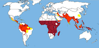
Areas of the world where malaria has been a major disease and in many
cases, still is. Note that Malaria transmission does not occur in
Baja California or anywhere in the United States, which suggests these areas do
not qualify for the Land of Promise per Alma 46:40
The word “malaria,” of course, was unknown in Joseph Smith’s time and did not come into use until the mid 18th century: from Italian, from mal'aria, contracted form of mala aria “bad air.” The term originally denoted the unwholesome atmosphere caused by the exhalations of marshes, to which the disease was formerly attributed. Thus, to curb “malaria,” the Romans drained the many swamps that existed within the city area to reduce the “horrible fumes.”

Top Left: Cinchona tree only grew in Andean Peru until the 1850s;
Middle: The bark was stripped; Right: then dried; Bottom left: Then broken
down, and Right: finally crushed into a powder
What is important to know is that until the Dutch stole the secret of making quinine from the Peruvians in 1851—until then, the cinchona tree and quinine were found only in Andean Peru.
Thus, Peru is the only place in the world where an herbal plant grew that cured or treated killing fevers as Mormon describes. “...but not so much so with fevers, because of the excellent qualities of the many plants and roots which God had prepared to remove the cause of diseases, to which men were subject by the nature of the climate” (Alma 46:40).
It is interesting that no theorist, historian or Land of Promise promoter has bothered to consider the reality of this and recognize that only Andean Peru meets this most important description for the location of the Land of Promise.
Another area of interest is that of highways and roads, for Mormon made it clear that the Nephites had “many highways cast up, and many roads made, which led from city to city, and from land to land, and from place to place” (3 Nephi 6:8). This suggests a very extensive and complete road system with highways and secondary roads that were built throughout the Nephite nation. Such roads, if at all built with solid material, which the word “highway” suggests, would still be visible today at least in certain areas of what had been the Land of Promise. Since there are only two locations in the entire Western Hemisphere that has roads dating back to B.C. times visible today, Andean Peru and Mesoamerica, that should at least eliminate North America, Baja California, Malay, etc. It seems noteworthy that Heartland, Great Lakes and Eastern U.S. theorists never mention that idea of roads as a means of verifying their models. It should also be noteworthy that of Mesoamerica and Andean Peru, only the latter has roads of high quality, differentiating between main “highways” and secondary “roads.” Yet, one cannot deny their existence, and their matching the description written by Mormon 1600 years ago. So why do we not consider that as evidence of the Book of Mormon?

Left: Llama; Right:
Alpaca
Or the two unknown grains the Nephites had and called the neas and sheum, as Mormon stated: “And we began to till the ground, yea, even with all manner of seeds, with seeds of corn, and of wheat, and of barley, and with neas, and with sheum, and with seeds of all manner of fruits; and we did begin to multiply and prosper in the land.” (Mosiah 9:9) Again, one would be hard-pressed to find two super grains like quinoa and kiwicha found in and indigenous to Andean Peru, with a long history dating back into B.C. times, that have so much value and were extant during Nephi times. So why do we not consider these two Andean supergrains as evidence of the Book of Mormon?

Top: Harvesting Quinoa; Bottom:
Abundance of Quinoa seeds in Andean Peru. The growing
global demand for quinoa by health food enthusiasts isn't just raising prices
for the Andean "super grain" and living standards among Bolivian
farmers. Quinoa fever is running up against physical limits. In fact, Quinoa
has been cultivated in the Andean highlands since at least 3000 B.C., growing
natively from Chile north to Colombia. It grows best at high altitudes in
climates with cool days and even cooler nights
Not only do we have numerous instances of Book of Mormon evidences found in the area of Andean South America, but that most of them are only found there—so why is it we are not claiming that Andean Peru is the Land of Promise, and discounting all these other areas which simply do not have any of the evidences Nephi, Jacob, Mormon and Moroni describe as being in the Land of Promise? Certainly the archaeological evidence is overwhelming available. But looking for it in North America, Mesoamerica, Malay and elsewhere will not find it—only in Andean South America.
Friday, April 28, 2017
Why Has No Evidence of the Nephites Been Found? – Part III
Continuing from the previous article
regarding the reason why proof of Book of Mormon archaeology is not apparent,
but that it exists. So what has been found?
 First of all, before getting into
that, we need to keep in mind that artifacts, finds, and archaeological
determinations are often very subjective. As an example, for many years the
story of Christ healing a man at the pool of Bethesda was mocked by critics
since no pool had ever been located, and the entire event labeled a myth
without merit. One of the problems was that the pool was described as having
five porticoes—a puzzling feature suggesting an unusual five-sided pool, which
most scholars dismissed as an unhistorical literary creation. The fact that no
such pool was found in the vicinity of its Biblical description also led to
this critique of it not being a factual story.
First of all, before getting into
that, we need to keep in mind that artifacts, finds, and archaeological
determinations are often very subjective. As an example, for many years the
story of Christ healing a man at the pool of Bethesda was mocked by critics
since no pool had ever been located, and the entire event labeled a myth
without merit. One of the problems was that the pool was described as having
five porticoes—a puzzling feature suggesting an unusual five-sided pool, which
most scholars dismissed as an unhistorical literary creation. The fact that no
such pool was found in the vicinity of its Biblical description also led to
this critique of it not being a factual story.
However, in 2013, a pool was discovered in Jerusalem during an excavation that located the Bethesda Pool, or mikveh—the celebrated ritual bath of the scriptural record. It was found in Jerusalem’s Qiryat Menachem neighborhood that dates back to the Second Temple period (538 B.C.E–70 C.E.).
Small pools used for ritual cleansing, then known as mikva’ot (singular, mikveh), were built to strict specifications: According to the Mishnah, the earliest rabbinic code of law, they had to be of a certain size and filled with “living” water—water that was not transferred from a vessel but has flowed directly into the bath from a river, spring or rainwater collector.
 The recently-discovered Jerusalem mikveh featured a unique water supply
system designed to preserve every possible drop of rainwater collected in the
arid Jerusalem environment. Water ran into the mikveh from three collecting basins (otzar) hewn out of the rock on the mikveh’s roof, following kashrut
laws dictating that the water be carried in naturally and without human
contact. In addition, the mikveh was
paved with plaster, following the Jewish law that water from the mikveh not seep into the earth.
The recently-discovered Jerusalem mikveh featured a unique water supply
system designed to preserve every possible drop of rainwater collected in the
arid Jerusalem environment. Water ran into the mikveh from three collecting basins (otzar) hewn out of the rock on the mikveh’s roof, following kashrut
laws dictating that the water be carried in naturally and without human
contact. In addition, the mikveh was
paved with plaster, following the Jewish law that water from the mikveh not seep into the earth.
While the area was used for quarrying after the mikveh went out of use, Jerusalem archaeologists are working with the neighboring community and the Israel Antiquities Authority to preserve the site of this unique Second Temple period mikveh.
Interestingly, revealed in the excavation was the rectangular pool with two basins separated by a wall—thus a five-sided pool—and each side had a portico. Why two basins? The archaeological evidence shows that the southern basin had broad steps with landings, indicating that it was indeed a mikveh. The northern basin provided a reservoir, or otzer, to continually replenish and repurify the mikveh with fresh water flowing south through the dam between them. Anciently, Jerusalem’s pilgrims would flock to the Bethesda Pool and Siloam Pool to purify themselves in these public mikva’ot and, at times, to seek healing.

Until the discovery of the pool with
five-roofed colonnades near the Sheep Gate (although everyone was looking for a
pentagon shaped pool at first), many did not consider the Gospel of John
to be historically reliable. The gospel was thought to be either allegorical

However, in 2013, a pool was discovered in Jerusalem during an excavation that located the Bethesda Pool, or mikveh—the celebrated ritual bath of the scriptural record. It was found in Jerusalem’s Qiryat Menachem neighborhood that dates back to the Second Temple period (538 B.C.E–70 C.E.).
Small pools used for ritual cleansing, then known as mikva’ot (singular, mikveh), were built to strict specifications: According to the Mishnah, the earliest rabbinic code of law, they had to be of a certain size and filled with “living” water—water that was not transferred from a vessel but has flowed directly into the bath from a river, spring or rainwater collector.

While the area was used for quarrying after the mikveh went out of use, Jerusalem archaeologists are working with the neighboring community and the Israel Antiquities Authority to preserve the site of this unique Second Temple period mikveh.
Interestingly, revealed in the excavation was the rectangular pool with two basins separated by a wall—thus a five-sided pool—and each side had a portico. Why two basins? The archaeological evidence shows that the southern basin had broad steps with landings, indicating that it was indeed a mikveh. The northern basin provided a reservoir, or otzer, to continually replenish and repurify the mikveh with fresh water flowing south through the dam between them. Anciently, Jerusalem’s pilgrims would flock to the Bethesda Pool and Siloam Pool to purify themselves in these public mikva’ot and, at times, to seek healing.

Top: The Bethesda Pool, where Jesus healed the paralytic man in the
Gospel of John. As can be seen, it is a complex site, and appearing to have
been a mikveh, or ritual
bath. As the spot of one of Jesus’ miracles, the Bethesda Pool was built over
in subsequent periods with chapels and churches that are still visible today;
Bottom: The mikveh from above, showing the three collecting basins hewn into
the roof of the mikveh. Photo: Israel Antiquities Authority
(truthful only in the sense similar to apocalyptic literature) or simply
inaccurate (written by someone who was not from Judea and was wholly unfamiliar
with Jerusalem’s geography and topography). However, both pools mentioned in
the Gospel of John were identified—the Pool of Bethesda in John 5:2 and the
Pool of Siloam in John 9:7. One of the pools turned out to have five colonnades
(as described in the Gospel), but it was not structured as a pentagon. There
were four colonnades separated in the middle by another one, thus forming the
five colonnades just as the Gospel described. Since its discovery, the pool has
been heralded as the one mentioned in the writings of John.
Now, the question arises, what proof is it that this particular excavation revealed the same pool that is outlined in scripture? There was no sign buried in the area saying this was that pool. There is no specific determining factors that tells anyone what it is, other than a five-sided portico area where water had been stored. It is not even known specifically if this is the exact same spot though it is in the general area. The point is, the find is recognized for what it very much appears to be, the Bethesda Pool.
 Now
contrast this with a specific description regarding the tower King Noah built
in the city of Nephi in the Land of Promise, that was, as described in Mosiah
11:12-13:
Now
contrast this with a specific description regarding the tower King Noah built
in the city of Nephi in the Land of Promise, that was, as described in Mosiah
11:12-13:
1. Tower was near the temple,
2. Tower was very high,
3. You could stand on top,
4. Tower overlooked the land of Shilom,
5. Tower overlooked the land of Shemlon,
6. Tower provided a view over all the land round about,
7. Tower built on a hill north of the land of Shilom,
8. A resort (fort) was next to the tower.
Now such a tower existed on a hill to the north of the valley, overlooking the city of Cuzco, the main city in Peru at the time and the center of both Lamanite or Inca culture. This tower was quite high, built next to a temple, and also next to a large fortress, and overlooked the entire valley below and adjacent lands. During a rebellion, the Inca climbed up on this tower and jumped off to his death, which caused the Spanish to tear it down, leaving only the stone foundation base clearly seen and identified today as the foundation or base of a tall, round tower.
 The
find in Cuzco, Peru, known today as Sacsayhuaman, is so closely aligned to the
description in Mosiah of King Noah’s tower, that it can hardly be considered
anything else, since it is exactly where Mormon placed it. But is it considered
Noah’s tower? Certainly not by the mainstream of Book of Mormon geography. Yet,
there it is, right where some of us believed it to be and see it described in
Mosiah’s writings.
The
find in Cuzco, Peru, known today as Sacsayhuaman, is so closely aligned to the
description in Mosiah of King Noah’s tower, that it can hardly be considered
anything else, since it is exactly where Mormon placed it. But is it considered
Noah’s tower? Certainly not by the mainstream of Book of Mormon geography. Yet,
there it is, right where some of us believed it to be and see it described in
Mosiah’s writings.
The point is, there are numerous places that should be considered fulfillment of Book of Mormon sites in Andean South America, just like the Pool of Bethesda is now known to exist in Jerusalem as once described but unknown for nearly 2000 years. And this is not the only edifice or connection found in Andean Peru, but just one of many.
(See the next post, “Why Has No Evidence of the Nephites Been Found – Part IV,” for more information why when the critics ask about evidence you have a legitimate and accurate answer)
Now, the question arises, what proof is it that this particular excavation revealed the same pool that is outlined in scripture? There was no sign buried in the area saying this was that pool. There is no specific determining factors that tells anyone what it is, other than a five-sided portico area where water had been stored. It is not even known specifically if this is the exact same spot though it is in the general area. The point is, the find is recognized for what it very much appears to be, the Bethesda Pool.

1. Tower was near the temple,
2. Tower was very high,
3. You could stand on top,
4. Tower overlooked the land of Shilom,
5. Tower overlooked the land of Shemlon,
6. Tower provided a view over all the land round about,
7. Tower built on a hill north of the land of Shilom,
8. A resort (fort) was next to the tower.
Now such a tower existed on a hill to the north of the valley, overlooking the city of Cuzco, the main city in Peru at the time and the center of both Lamanite or Inca culture. This tower was quite high, built next to a temple, and also next to a large fortress, and overlooked the entire valley below and adjacent lands. During a rebellion, the Inca climbed up on this tower and jumped off to his death, which caused the Spanish to tear it down, leaving only the stone foundation base clearly seen and identified today as the foundation or base of a tall, round tower.

The point is, there are numerous places that should be considered fulfillment of Book of Mormon sites in Andean South America, just like the Pool of Bethesda is now known to exist in Jerusalem as once described but unknown for nearly 2000 years. And this is not the only edifice or connection found in Andean Peru, but just one of many.
(See the next post, “Why Has No Evidence of the Nephites Been Found – Part IV,” for more information why when the critics ask about evidence you have a legitimate and accurate answer)
Thursday, April 27, 2017
Why Has No Evidence of the Nephites Been Found? – Part II
Continuing from the previous article
regarding the reason why proof of Book of Mormon archaeology is not apparent,
but that it exists. In the first article on this, we ended
with the idea of signs or information in an unknown or other language and how
might it be interpreted. Certainly, no non-LDS archaeologist would venture to
connect what was found with the Book of Mormon. Take for instance, the
difficulty in understanding things in Andean Peru—yet written information
exists, at least after a fashion, but no one can read it, on the khipus, often
called khipus, that exist there in large numbers.
Since no one is certain of their
interpretation, or even if words exist on the khipus other than the numbering
system that has been somewhat analyzed. What if this set of cords actually said
“The city of Zarahemla, in the land of Zarahemla, was located beyond the Sidon
River”? Is there anyone today that could interpret that? Would they even know
how?
Individual khipus seem to have varied widely in color and complexity; most of the surviving examples generally consist of a pencil-thick primary cord, from which hang multiple "pendant" cords. From those pendants hang ancillary cords called "subsidiaries." One khipu has more than a thousand subsidiary cords.
Sixteenth-century eyewitness accounts describe khipucamayocs studying their khipus intensely to access whatever details had been recorded on them. What if the same knot on different colored cords meant something different? According to Spanish chronicles of the 1560s and 1570s, some khipus appeared to contain information of the sort that other cultures have typically preserved in writing, such as genealogies and songs that praised the king. One Jesuit missionary told of a woman who brought him a khipus on which she had "written a confession of her whole life."
So what if the woman’s confession actually read “while serving as a nurse at Zarahemla, I committed…” Would anyone know that today?
Until those cords, colors and knots can be correctly interpreted, there is no way of knowing what names, places, lands or peoples might be mentioned in the khipus writing. After all, it has been suggested that the only use of khipus was to list numbers, while other knots have been assigned arbitrary letters. However, several different linguist working with the khipus have come up with different assigned letters, with no agreement in sight.
 Always clouding the issue with
knee-jerk reactions of “devil worship” to things they did not understand, the Spaniards'
institutional response to this singular accounting or communication system, originally benign
toward the khipus, shifted in 1583, when Peru's rising Roman Catholic church that
was just beginning to exercise its authority in the New World, decreed that khipus
were the devil's work and ordered the destruction of every khipus in the former
Inca empire. (This was the heyday of the Spanish Inquisition, and the church
was making a major push to convert natives from their pantheistic state
religion.)
Always clouding the issue with
knee-jerk reactions of “devil worship” to things they did not understand, the Spaniards'
institutional response to this singular accounting or communication system, originally benign
toward the khipus, shifted in 1583, when Peru's rising Roman Catholic church that
was just beginning to exercise its authority in the New World, decreed that khipus
were the devil's work and ordered the destruction of every khipus in the former
Inca empire. (This was the heyday of the Spanish Inquisition, and the church
was making a major push to convert natives from their pantheistic state
religion.)
By the middle of the 17th century, Spanish accounts, the only historical sources available from that time, began to cast doubt on the idea that the khipus had ever been "read" like texts. Instead, the knots on khipus came to be viewed as mnemonic prompts analogous to the beads on Catholic rosaries, cues that supposedly had helped the khipucamayocs recall information that they had already memorized. Some scholars argued that a khipus could have only been understood by the same khipucamayoc who'd made it.
 However, beyond 1583, Andean cultures secretly
continued to use knotted cords to record information well into the 20th
century, but the links between modern cords and Inca khipus aren't clear. What's certain is that no one in recent history has been able to fully
interpret an Inca khipus, and that today there is much disagreement about them.
However, beyond 1583, Andean cultures secretly
continued to use knotted cords to record information well into the 20th
century, but the links between modern cords and Inca khipus aren't clear. What's certain is that no one in recent history has been able to fully
interpret an Inca khipus, and that today there is much disagreement about them.
One can compare the difficulty in understanding what is contained within the khipus with the Maya hieroglyphs until they were finally interpreted recently. First efforts were made in the 16th century, and revitalized in the 19th century, and then finally additional work was begun in the 20th century, with the final key added in 1981. Today, with the revelation of Yuri Knorosov, a fifteen-year-old fledging Mayanist, scholars can read many glyphs once considered indecipherable, now reading the majority of glyphs available. This combined effort of at least ten major players over nearly four hundred years.
On the other hand, Rongorongo of Easter Island, was not first seen by Westerners until 1864, when Eugène Eyraid, a lay friar of the Congrégation de Picpus, landed on the island and saw hundreds of written tablets of small wooden boards covered in hieroglyphic writing, but learned that the islanders could not agree on how to read them and none could decipher them. As Eyraid wrote two years later, “In every hut one finds wooden tablets or sticks covered in several sorts of hieroglyphic characters: They are depictions of animals unknown on the island, which the natives draw with sharp stones. Each figure has its own name; but the scant attention they pay to these tablets leads me to think that these characters, remnants of some primitive writing, are now for them a habitual practice which they keep without seeking its meaning.” Unfortunately, shortly after most of these boards disappeared, whether destroyed deliberately or accidentally is unknown, but by 1868, there were only a handful left to be seen. The first effort to seriously investigate the writing did not occur until 1914, and a published reference to the glyphs which is even close to comprehensive understanding did not appear until 1958, and another comprehensive work in 1997. However, as with most undeciphered scripts, there are many fanciful interpretations and claimed translations of rongorongo; but apart from a portion of one tablet which has been shown to have to do with a lunar Rapa Nui calendar, none of the texts are understood.
 On the other hand, the Maya glyphs are a different story,
though they were not interpreted until recently, and the language became readable. As an example, Yucatec Maya (Yukatek Maya) in
the revised orthography, that is the set of conventions for writing a language
(such as the differences between American English and British English), that is
called Màaya t'àan ("Maya speech") by its speakers, is a Mayan
language spoken in the Yucatán Peninsula and northern Belize. To native
speakers, the proper name is Maya and it is known only as Maya. The qualifier
"Yucatec" is a tag linguists use to distinguish it from other Mayan
languages (such as K’iche’ and Itza’). Thus the use of the term Yucatec Maya to
refer to the language is scientific jargon or nomenclature.
On the other hand, the Maya glyphs are a different story,
though they were not interpreted until recently, and the language became readable. As an example, Yucatec Maya (Yukatek Maya) in
the revised orthography, that is the set of conventions for writing a language
(such as the differences between American English and British English), that is
called Màaya t'àan ("Maya speech") by its speakers, is a Mayan
language spoken in the Yucatán Peninsula and northern Belize. To native
speakers, the proper name is Maya and it is known only as Maya. The qualifier
"Yucatec" is a tag linguists use to distinguish it from other Mayan
languages (such as K’iche’ and Itza’). Thus the use of the term Yucatec Maya to
refer to the language is scientific jargon or nomenclature.
The point is, that even with written material, interpreting information is a long, drawn-out process, with many ancient languages remaining unreadable by modern man. What most people do not understand is that those who had determined the past, have done so with the meagerest of information, in many cases a paucity of artifacts and in far too many cases, an over-imaginative imagination.
(See the next post, “Why Has No Evidence of the Nephites Been Found – Part III,” for more information why when the critics ask about evidence you have a legitimate and accurate answer)

Since so much about the khipus are unknown to us today, the different
colors, length of cord, placement of knots, size of knots, etc., etc., etc.,
are all unknown—what if it is a language of sorts and was understood as such
anciently?
Individual khipus seem to have varied widely in color and complexity; most of the surviving examples generally consist of a pencil-thick primary cord, from which hang multiple "pendant" cords. From those pendants hang ancillary cords called "subsidiaries." One khipu has more than a thousand subsidiary cords.
Sixteenth-century eyewitness accounts describe khipucamayocs studying their khipus intensely to access whatever details had been recorded on them. What if the same knot on different colored cords meant something different? According to Spanish chronicles of the 1560s and 1570s, some khipus appeared to contain information of the sort that other cultures have typically preserved in writing, such as genealogies and songs that praised the king. One Jesuit missionary told of a woman who brought him a khipus on which she had "written a confession of her whole life."
So what if the woman’s confession actually read “while serving as a nurse at Zarahemla, I committed…” Would anyone know that today?
Until those cords, colors and knots can be correctly interpreted, there is no way of knowing what names, places, lands or peoples might be mentioned in the khipus writing. After all, it has been suggested that the only use of khipus was to list numbers, while other knots have been assigned arbitrary letters. However, several different linguist working with the khipus have come up with different assigned letters, with no agreement in sight.

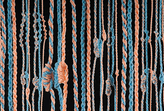
One example of one linguist's interpretation. Note the similarity between some numbers and some letters; and at the
bottom left, there are samples of reversed direction that is presently undecipherable
By the middle of the 17th century, Spanish accounts, the only historical sources available from that time, began to cast doubt on the idea that the khipus had ever been "read" like texts. Instead, the knots on khipus came to be viewed as mnemonic prompts analogous to the beads on Catholic rosaries, cues that supposedly had helped the khipucamayocs recall information that they had already memorized. Some scholars argued that a khipus could have only been understood by the same khipucamayoc who'd made it.

One can compare the difficulty in understanding what is contained within the khipus with the Maya hieroglyphs until they were finally interpreted recently. First efforts were made in the 16th century, and revitalized in the 19th century, and then finally additional work was begun in the 20th century, with the final key added in 1981. Today, with the revelation of Yuri Knorosov, a fifteen-year-old fledging Mayanist, scholars can read many glyphs once considered indecipherable, now reading the majority of glyphs available. This combined effort of at least ten major players over nearly four hundred years.
On the other hand, Rongorongo of Easter Island, was not first seen by Westerners until 1864, when Eugène Eyraid, a lay friar of the Congrégation de Picpus, landed on the island and saw hundreds of written tablets of small wooden boards covered in hieroglyphic writing, but learned that the islanders could not agree on how to read them and none could decipher them. As Eyraid wrote two years later, “In every hut one finds wooden tablets or sticks covered in several sorts of hieroglyphic characters: They are depictions of animals unknown on the island, which the natives draw with sharp stones. Each figure has its own name; but the scant attention they pay to these tablets leads me to think that these characters, remnants of some primitive writing, are now for them a habitual practice which they keep without seeking its meaning.” Unfortunately, shortly after most of these boards disappeared, whether destroyed deliberately or accidentally is unknown, but by 1868, there were only a handful left to be seen. The first effort to seriously investigate the writing did not occur until 1914, and a published reference to the glyphs which is even close to comprehensive understanding did not appear until 1958, and another comprehensive work in 1997. However, as with most undeciphered scripts, there are many fanciful interpretations and claimed translations of rongorongo; but apart from a portion of one tablet which has been shown to have to do with a lunar Rapa Nui calendar, none of the texts are understood.

The point is, that even with written material, interpreting information is a long, drawn-out process, with many ancient languages remaining unreadable by modern man. What most people do not understand is that those who had determined the past, have done so with the meagerest of information, in many cases a paucity of artifacts and in far too many cases, an over-imaginative imagination.
(See the next post, “Why Has No Evidence of the Nephites Been Found – Part III,” for more information why when the critics ask about evidence you have a legitimate and accurate answer)
Wednesday, April 26, 2017
Why Has No Evidence of the Nephites Been Found? – Part I
We
have been asked this numerous times and almost every critic makes an issue out
of it, and despite numerous evidences to the opposite, even members are
convinced this is the case—that there is no real evidence of Book of Mormon
Land of Promise. However,
before getting into this totally erroneous concept, we need to get two things
clearly understood:
 1.
European and Asian archaeology follows a well-known pattern of areas that have
always been occupied with continuance by the same or similar cultures and
peoples, with an understanding of former names of places and that of former
inhabitants. As an example, Bethlemem has always been called Bethlehem, which
name dates back to 1350 B.C. during its habitation by the Canaanites, as found
in the Amarna correspondence written on
clay tablets during the 18th Dynasty of Egypt. On the other hand, Jerusalem,
at one time, was called Salem (Sãlim). It is known to be the same place in the
same area, and its earliest inhabitants, the Canaanites, had a god (of sunset)
called Shalem (Shalim), and their home was named uru-salim, meaning “founded by
the god Shalim.” It has variously been called Ierousalem,
Hierousalem, Hierusalem, Hierosolyma, and Solyma (a vague reference to mountains
around the Dead Sea and/or “Palestinian Syrians”)—eventually evolving to Yerûshlem.
At an earlier date it was known to the Arabs as Aurishalamu, and to the early
Babyonians as Ur-sa-li-immu, causing an unknown origination as to whether it
was a Babylonian derivative of origin or Canaanite. In fact, most experts on
the matter claim that the etymology of Jerusalem is almost impossible to know
for certain. Still, the constant occupation of the area leads us to know what
its name was and now is.
1.
European and Asian archaeology follows a well-known pattern of areas that have
always been occupied with continuance by the same or similar cultures and
peoples, with an understanding of former names of places and that of former
inhabitants. As an example, Bethlemem has always been called Bethlehem, which
name dates back to 1350 B.C. during its habitation by the Canaanites, as found
in the Amarna correspondence written on
clay tablets during the 18th Dynasty of Egypt. On the other hand, Jerusalem,
at one time, was called Salem (Sãlim). It is known to be the same place in the
same area, and its earliest inhabitants, the Canaanites, had a god (of sunset)
called Shalem (Shalim), and their home was named uru-salim, meaning “founded by
the god Shalim.” It has variously been called Ierousalem,
Hierousalem, Hierusalem, Hierosolyma, and Solyma (a vague reference to mountains
around the Dead Sea and/or “Palestinian Syrians”)—eventually evolving to Yerûshlem.
At an earlier date it was known to the Arabs as Aurishalamu, and to the early
Babyonians as Ur-sa-li-immu, causing an unknown origination as to whether it
was a Babylonian derivative of origin or Canaanite. In fact, most experts on
the matter claim that the etymology of Jerusalem is almost impossible to know
for certain. Still, the constant occupation of the area leads us to know what
its name was and now is.
2. The Western Hemisphere has a totally different history, than that of non-continuation. That is, the first occupation of which we know is that of the Jaredites, who had no interaction with the Nephites, spoke a different language, and did not occupy at any time the lands of the Nephites except in the Land Northward—even so, an occupation or settlement gap of some 500 years in that land existed. Plus, after the annihilation of the Nephites, there was a thousand years of occupation by a totally different speaking people, who were a sworn enemy of the Nephites and willing and eager to destroy and eradicate anything Nephite. Thus, we see a total lack of continuance in the Western Hemisphere where names, heritage, and understanding was totally lacking between occupants.
 This,
then, gives us a starting point in the Western Hemisphere where there exists
absolutely no continuation of names, places, historical connections or even
interest. Not until the Spanish arrived, and with them their chroniclers, who
were only mildly curious about the past beyond writing of the Maya, Aztec and
Inca civilizations, but not of trying to delve further back in history (what
there was of it known to those cultures).
This,
then, gives us a starting point in the Western Hemisphere where there exists
absolutely no continuation of names, places, historical connections or even
interest. Not until the Spanish arrived, and with them their chroniclers, who
were only mildly curious about the past beyond writing of the Maya, Aztec and
Inca civilizations, but not of trying to delve further back in history (what
there was of it known to those cultures).
As a result, what little was learned of the present inhabitants during the Spanish occupation surrounded such matters as to their own beginnings, which rarely extended beyond the immediate and a few myths and legends, treated as such by the chroniclers who had an entirely different viewpoint of the world and human existence than those they had conquered (Native Americans today, whom we called Indians, claim the people and government has no understanding of them and their history, religion, and heritage even after several hundred years and millions of pages written about the more than 250 tribes or bands living in the U.S.)
We are not even certain today what numerous “Indian” names meant and, in fact, most aboriginal words have several meanings. Mississippi, as an example means “Father of Waters,” “Large River,” “Ancient of Rivers,” “Ancient Father of Waters,” “Big River,” “Good River,” or “Great River.” Another example is the word “Ohio,” which is claimed to mean “Great River,” “Large Creek,” “Good River,” “Beautiful River,” “River running through a red place,” or “The Great One.“
 The
point is, to believe that a name of a place, city, land, etc., which might have
been handed down through Nephite, to Lamanite, to Spanish, would retain its
original meaning, and thus be re-translatable, would be rare indeed. We also
understand from the Hebrew that names were often fluid, that is, they were
changed by succeeding generations, as in Lehi naming a river the “River of
Laman” or a valley, the “Valley of Lemuel.” Or in his naming an entire ocean
“Irreantum,” and where they settled for a year or two “Bountiful”—all names
that would not have remained after Lehi left those areas.
The
point is, to believe that a name of a place, city, land, etc., which might have
been handed down through Nephite, to Lamanite, to Spanish, would retain its
original meaning, and thus be re-translatable, would be rare indeed. We also
understand from the Hebrew that names were often fluid, that is, they were
changed by succeeding generations, as in Lehi naming a river the “River of
Laman” or a valley, the “Valley of Lemuel.” Or in his naming an entire ocean
“Irreantum,” and where they settled for a year or two “Bountiful”—all names
that would not have remained after Lehi left those areas.
Now, having suggested these kinds of problems, let us turn to archaeology. The first thing an archaeologist on site does is to give the area a name. In North America, places were often named originally by French trappers, who typically used a local Indian name as they translated it into French, like the French who first heard the Iroquois word “ohi-yo,” which they understood to mean “great” or “large.” They translated this to “La Belle Riviere” meaning the Beautiful River.
When Michael Moseley and Carol J. Mackey began excavations in 1969 of a coastal area in northern Peru, they used the pre-Columbian Chimú Quingnam language word “Jiang,” to name it, which meant “Sun,” because of the hot, sunny climate. Typically, in Quingnam, repeating or the reduplication of a word gives it special meaning and the term became Chan Chan, meaning “Sun Sun,” hypothesizing that its true meaning would be: “Great sun,” “Resplendent Sun,” “Splendid Sun” or “Refulgent Sun.”

It
would be like calling the Great Salt Lake “Gran
Lago Salado” in Spanish, or “grand la
salé,” in French, or “sumaj kachi qhocha” in Quechua, for a place known
locally as “large lake of salt” to a people who neither knew or could
understand Spanish, French or Quechua.
What if you came across the term “alliçupa” for the name of a city in Andean Peru. Would you know that could mean Los Angeles, i.e., “City of Angels”? What if you were looking for the city of Pachacamac outside Lima and ran across a reference to ruraquen in Quechua, would you or an archaeologist know that both terms could mean the same thing at a time when Quechua was unknown?
As an example, supposing an original name of a river in Peru was called Mesad. Would you tie this into the Book of Mormon as Nephite evidence? However, if you could trace this word (feminine noun meaning “fastness”), connected to the same root word meaning “hunting” through its root of Sud, which is the root word of Sidon, one might say there is a connection. However, who would know that of a Quechua word term, since not even the Quechuan-speaking people of the Andes know the root of many of the words they speak. The point is, finding connections linguistically is as chancy as finding a sign buried in the ground saying “This is the city of Zarahemla.”
(See the next post, “Why Has No Evidence of the Nephites Been Found – Part II,” for more information why when the critics ask about evidence you have a legitimate and accurate answer)

2. The Western Hemisphere has a totally different history, than that of non-continuation. That is, the first occupation of which we know is that of the Jaredites, who had no interaction with the Nephites, spoke a different language, and did not occupy at any time the lands of the Nephites except in the Land Northward—even so, an occupation or settlement gap of some 500 years in that land existed. Plus, after the annihilation of the Nephites, there was a thousand years of occupation by a totally different speaking people, who were a sworn enemy of the Nephites and willing and eager to destroy and eradicate anything Nephite. Thus, we see a total lack of continuance in the Western Hemisphere where names, heritage, and understanding was totally lacking between occupants.

As a result, what little was learned of the present inhabitants during the Spanish occupation surrounded such matters as to their own beginnings, which rarely extended beyond the immediate and a few myths and legends, treated as such by the chroniclers who had an entirely different viewpoint of the world and human existence than those they had conquered (Native Americans today, whom we called Indians, claim the people and government has no understanding of them and their history, religion, and heritage even after several hundred years and millions of pages written about the more than 250 tribes or bands living in the U.S.)
We are not even certain today what numerous “Indian” names meant and, in fact, most aboriginal words have several meanings. Mississippi, as an example means “Father of Waters,” “Large River,” “Ancient of Rivers,” “Ancient Father of Waters,” “Big River,” “Good River,” or “Great River.” Another example is the word “Ohio,” which is claimed to mean “Great River,” “Large Creek,” “Good River,” “Beautiful River,” “River running through a red place,” or “The Great One.“

Now, having suggested these kinds of problems, let us turn to archaeology. The first thing an archaeologist on site does is to give the area a name. In North America, places were often named originally by French trappers, who typically used a local Indian name as they translated it into French, like the French who first heard the Iroquois word “ohi-yo,” which they understood to mean “great” or “large.” They translated this to “La Belle Riviere” meaning the Beautiful River.
When Michael Moseley and Carol J. Mackey began excavations in 1969 of a coastal area in northern Peru, they used the pre-Columbian Chimú Quingnam language word “Jiang,” to name it, which meant “Sun,” because of the hot, sunny climate. Typically, in Quingnam, repeating or the reduplication of a word gives it special meaning and the term became Chan Chan, meaning “Sun Sun,” hypothesizing that its true meaning would be: “Great sun,” “Resplendent Sun,” “Splendid Sun” or “Refulgent Sun.”

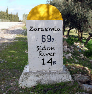
Do you know this familiar lake? What if you stumbled on it if you didn’t
know where you were? Would you know from the sign?
What if you came across the term “alliçupa” for the name of a city in Andean Peru. Would you know that could mean Los Angeles, i.e., “City of Angels”? What if you were looking for the city of Pachacamac outside Lima and ran across a reference to ruraquen in Quechua, would you or an archaeologist know that both terms could mean the same thing at a time when Quechua was unknown?
As an example, supposing an original name of a river in Peru was called Mesad. Would you tie this into the Book of Mormon as Nephite evidence? However, if you could trace this word (feminine noun meaning “fastness”), connected to the same root word meaning “hunting” through its root of Sud, which is the root word of Sidon, one might say there is a connection. However, who would know that of a Quechua word term, since not even the Quechuan-speaking people of the Andes know the root of many of the words they speak. The point is, finding connections linguistically is as chancy as finding a sign buried in the ground saying “This is the city of Zarahemla.”
(See the next post, “Why Has No Evidence of the Nephites Been Found – Part II,” for more information why when the critics ask about evidence you have a legitimate and accurate answer)
Tuesday, April 25, 2017
What about Ancient Technology? – Part III
Continuing from the last post with more on the ancient technologies of the
Nephite era, despite many people believing these early cultures were incapable
of achieving modern-level accomplishments in many fields, especially in
building and developing their communities with modern-style convenience, such
as the Heartland, Great Lakes and Eastern U.S. theorists who claim the Nephites
settled in stick huts with thatched roofs. Or the theorists who promote Malay
and Baja California, again, where no structures of an advanced civilization of
the Nephite era are found.
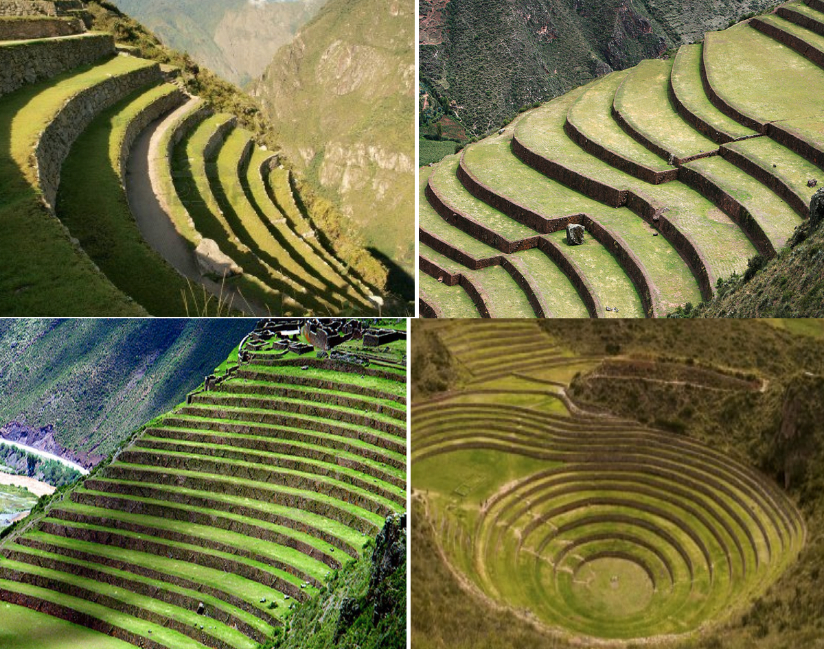
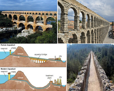
 Take for
example, the subject of agriculture, which has driven every society that ever
was, some with outstanding efforts and results. As an example, the ancient
people of Peru built water-moving and preserving technologies like the
aqueducts of Cumbe Mayo (1500 B.C.) or the Nazca’s underground aqueducts called
Puquios, or the terraced gardens of the Huari. In fact, the technique of
terracing the many steep mountainsides in Andean Peru. These andenes, or
terraces, reduced soil erosion that would normally be high on a steep hill,
irrigating their fields with a system of reservoirs and cisterns to collect
water, which was then distributed by canals and ditches. For centuries, some
97% of the land of Peru was farmed in this manner—growing maize,
coca, beans, grains, potatoes, sweet potatoes, ulluco, oca, mashwa, pepper,
tomatoes, peanuts, cashews, squash, cucumber, quinoa, gourd, cotton, talwi,
carob, chirimoya, lúcuma, guayabo, and avocado.
Take for
example, the subject of agriculture, which has driven every society that ever
was, some with outstanding efforts and results. As an example, the ancient
people of Peru built water-moving and preserving technologies like the
aqueducts of Cumbe Mayo (1500 B.C.) or the Nazca’s underground aqueducts called
Puquios, or the terraced gardens of the Huari. In fact, the technique of
terracing the many steep mountainsides in Andean Peru. These andenes, or
terraces, reduced soil erosion that would normally be high on a steep hill,
irrigating their fields with a system of reservoirs and cisterns to collect
water, which was then distributed by canals and ditches. For centuries, some
97% of the land of Peru was farmed in this manner—growing maize,
coca, beans, grains, potatoes, sweet potatoes, ulluco, oca, mashwa, pepper,
tomatoes, peanuts, cashews, squash, cucumber, quinoa, gourd, cotton, talwi,
carob, chirimoya, lúcuma, guayabo, and avocado.
The early Peruvians were ambitious farmers, and to maximize agricultural production, they transformed the landscape with terracing, canals, and irrigation networks, while wetlands were often drained to make them suitable for farming. They were also fully aware of the values of regular crop rotation, and they also fertilized the land with dried llama dung, guano, or fish heads if these materials were available. Even so, the often harsh Andean climate could bring floods, droughts, and storms which, along with disease, meant that annual crop failures were not infrequent. In such cases their penchant for food storage came into its own.
 Foodstuffs (and other goods)
were stored in storehouses (qollqa)
which were built in the tens of thousands across the land, typically arranged
in neat rows and near population centers, large estates, and roadside stations.
These Qollqa were
single-roomed stone buildings, either circular or rectangular, which were built
in a remarkably uniform manner. Placed on hillsides to take advantage of cool
breezes, qollqa were
designed to maximize the storage time of the perishable goods with which they
were filled. They had drainage canals, gravel flooring, and ventilation in both
the floor and roof in order to keep the interior as cool and dry as possible so
that ordinary goods could be stored for up to two years and freeze-dried
foodstuffs for up to four years. Archaeologists have ascertained that maize,
potatoes, and quinoa were the most common foodstuffs stored in qollqa.
Foodstuffs (and other goods)
were stored in storehouses (qollqa)
which were built in the tens of thousands across the land, typically arranged
in neat rows and near population centers, large estates, and roadside stations.
These Qollqa were
single-roomed stone buildings, either circular or rectangular, which were built
in a remarkably uniform manner. Placed on hillsides to take advantage of cool
breezes, qollqa were
designed to maximize the storage time of the perishable goods with which they
were filled. They had drainage canals, gravel flooring, and ventilation in both
the floor and roof in order to keep the interior as cool and dry as possible so
that ordinary goods could be stored for up to two years and freeze-dried
foodstuffs for up to four years. Archaeologists have ascertained that maize,
potatoes, and quinoa were the most common foodstuffs stored in qollqa.
On steep hillsides and mountain slopes, the sun's rays don't reach deep enough in the valley, which remain cooler in their bottoms. The mountain sides ensure more intense sunlight for longer time during the day, and in some parts there is little space in the valleys, so the usage of steps actually increases the area available for agriculture. In addition they could better control the amount of water used for the irrigation of the plants. Benefits of these stepped terraces included defense against possible landslides and floods, since rainwater does not accumulate and run down on the towns below. The rocks used for creating the steps strengthened the sides of the mountains, thus protecting what is in the valleys from possible mudslides during heavy rainfall. The early Peruvians had to cope with floods that could have destroyed their agricultural fields and homes in the valleys. Higher ground protected the plantations from disaster and floods from overflowing rivers when intense rains increased their volumes.
 When other peoples had to wait for rains to come,
these early Peruvians were controlling the irrigation of the terraces by
diverting small quantities of water from mountain rivers, which eliminated the
threat of drought. Unlike in the case of the Maya civilization, which had
collapsed partly because of a long period of rainlessness, Peruvian cultures
were able to sustain themselves throughout the year. In addition, because of
the hillside terracing, they used different types of earth for different species
of plants, and controlled the quantity of water used accordingly.
When other peoples had to wait for rains to come,
these early Peruvians were controlling the irrigation of the terraces by
diverting small quantities of water from mountain rivers, which eliminated the
threat of drought. Unlike in the case of the Maya civilization, which had
collapsed partly because of a long period of rainlessness, Peruvian cultures
were able to sustain themselves throughout the year. In addition, because of
the hillside terracing, they used different types of earth for different species
of plants, and controlled the quantity of water used accordingly.
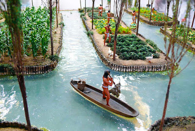
Another area of advanced agriculture was found in Mesoamerica, where the chinampa system—the so-called “floating gardens” which can be found on the shallow lake beds in the Valley of Mexico. These chinampa plots were constructed by staking out a rectangular enclosure into the marshy lake bed. The enclosure would then be fenced in by joining the stakes with wattle. After that, the fenced in area would be filled with mud and decaying vegetation. In order to prevent the roots from becoming water-logged, it was important that the fill brought the chinampa plot above the lake level, and canals surrounding the chinampa plots formed an illusion that these agricultural lands were floating on water, hence its misattribution as “floating gardens.” To further stabilize these plots of land, willows were planted around the perimeter, and over time their dense root system anchored the retaining walls of the structure and reduced the effects of erosion. In order to ensure that the chinampas produced good harvests throughout the year, it was vital that the supply of water was well managed. During the rainy season, flooding would have been a problem and a sophisticated drainage system, which included dams, sluice gates and canals, were put in place to counter this problem. These ancient Aztec agriculture and waste water treatment seen in the floating gardens of Mexico, was so advanced that there have been attempts (unsuccessfully) to implement it in modern times.
 Another interesting
advance of the ancients is that of city planning. In the
last century, numerous ancient cities have been unearthed that have astounded
scientists and urban planners alike. When archaeologists discovered the
5,000-year-old site of Mohenjo Daro in Pakistan, what they found was
unprecedented in the region--the city demonstrated an exceptional level of
civic planning and amenities. The
houses were furnished with brick-built bathrooms and many had toilets.
Wastewater from these was led into well-built brick sewers that ran along the
center of the streets, covered with bricks or stone slabs. Cisterns and wells
finely constructed of wedge-shaped bricks held public supplies of drinking
water. Back in its day, the city would have been home to around
40,000 inhabitants.
Another interesting
advance of the ancients is that of city planning. In the
last century, numerous ancient cities have been unearthed that have astounded
scientists and urban planners alike. When archaeologists discovered the
5,000-year-old site of Mohenjo Daro in Pakistan, what they found was
unprecedented in the region--the city demonstrated an exceptional level of
civic planning and amenities. The
houses were furnished with brick-built bathrooms and many had toilets.
Wastewater from these was led into well-built brick sewers that ran along the
center of the streets, covered with bricks or stone slabs. Cisterns and wells
finely constructed of wedge-shaped bricks held public supplies of drinking
water. Back in its day, the city would have been home to around
40,000 inhabitants.

In the same era, in Peru, another great city was being constructed, that of Caral, located in the Supe Valley in northern Peru. The ancient city consisted of huge monuments, including pyramids, plazas, amphitheaters, temples, and residential areas. They had extensive agriculture, ate a varied diet, developed the use of textiles, used a complex system for calculating and recording, built water supply, and developed an intricate irrigation system. Architects are currently looking to Caral for inspiration in city planning. Japanese architects intend to incorporate building designs that they implemented to protect their people from earthquakes—such as houses suspended in baskets filled with stones that dissipated earth movement and prevented collapse.
There is much evidence to support the fact that there have been many highly advanced civilizations that have been destroyed by global cataclysmic events, that show many of the ancients were advanced in their building as well as thinking far beyond what most people today would consider. To think that North American theorists regarding the Land of Promise has Lehi’s family,with a storied background of living in stone buildings in a city built entirely of stone, living in the New World in stick huts with thatched roofs instead of stone houses and paved highways as the scriptural record describes is simply unworthy of historical facts of the time and eras involved.

The early Peruvians were ambitious farmers, and to maximize agricultural production, they transformed the landscape with terracing, canals, and irrigation networks, while wetlands were often drained to make them suitable for farming. They were also fully aware of the values of regular crop rotation, and they also fertilized the land with dried llama dung, guano, or fish heads if these materials were available. Even so, the often harsh Andean climate could bring floods, droughts, and storms which, along with disease, meant that annual crop failures were not infrequent. In such cases their penchant for food storage came into its own.

On steep hillsides and mountain slopes, the sun's rays don't reach deep enough in the valley, which remain cooler in their bottoms. The mountain sides ensure more intense sunlight for longer time during the day, and in some parts there is little space in the valleys, so the usage of steps actually increases the area available for agriculture. In addition they could better control the amount of water used for the irrigation of the plants. Benefits of these stepped terraces included defense against possible landslides and floods, since rainwater does not accumulate and run down on the towns below. The rocks used for creating the steps strengthened the sides of the mountains, thus protecting what is in the valleys from possible mudslides during heavy rainfall. The early Peruvians had to cope with floods that could have destroyed their agricultural fields and homes in the valleys. Higher ground protected the plantations from disaster and floods from overflowing rivers when intense rains increased their volumes.
Another area of advanced agriculture was found in Mesoamerica, where the chinampa system—the so-called “floating gardens” which can be found on the shallow lake beds in the Valley of Mexico. These chinampa plots were constructed by staking out a rectangular enclosure into the marshy lake bed. The enclosure would then be fenced in by joining the stakes with wattle. After that, the fenced in area would be filled with mud and decaying vegetation. In order to prevent the roots from becoming water-logged, it was important that the fill brought the chinampa plot above the lake level, and canals surrounding the chinampa plots formed an illusion that these agricultural lands were floating on water, hence its misattribution as “floating gardens.” To further stabilize these plots of land, willows were planted around the perimeter, and over time their dense root system anchored the retaining walls of the structure and reduced the effects of erosion. In order to ensure that the chinampas produced good harvests throughout the year, it was vital that the supply of water was well managed. During the rainy season, flooding would have been a problem and a sophisticated drainage system, which included dams, sluice gates and canals, were put in place to counter this problem. These ancient Aztec agriculture and waste water treatment seen in the floating gardens of Mexico, was so advanced that there have been attempts (unsuccessfully) to implement it in modern times.


Top: Mohenjo Daro in Pakistan; Bottom: Caral in Peru
In the same era, in Peru, another great city was being constructed, that of Caral, located in the Supe Valley in northern Peru. The ancient city consisted of huge monuments, including pyramids, plazas, amphitheaters, temples, and residential areas. They had extensive agriculture, ate a varied diet, developed the use of textiles, used a complex system for calculating and recording, built water supply, and developed an intricate irrigation system. Architects are currently looking to Caral for inspiration in city planning. Japanese architects intend to incorporate building designs that they implemented to protect their people from earthquakes—such as houses suspended in baskets filled with stones that dissipated earth movement and prevented collapse.
There is much evidence to support the fact that there have been many highly advanced civilizations that have been destroyed by global cataclysmic events, that show many of the ancients were advanced in their building as well as thinking far beyond what most people today would consider. To think that North American theorists regarding the Land of Promise has Lehi’s family,with a storied background of living in stone buildings in a city built entirely of stone, living in the New World in stick huts with thatched roofs instead of stone houses and paved highways as the scriptural record describes is simply unworthy of historical facts of the time and eras involved.
Monday, April 24, 2017
What about Ancient Technology? – Part II
Continuing from the last post with more on the ancient technologies of the
Nephite era, despite many people believing these early cultures were incapable
of achieving modern-level accomplishments in many fields, especially in
building and developing their communities with modern-style convenience, such
as the Heartland, Great Lakes and Eastern U.S. theorists who claim the Nephites
settled in stick huts with thatched roofs.

The point
is, as discussed in the first article in this series, the Nephites had
asdvanced capability from such primitive cultures as those that settled in
North America during B.C. times. In fact, Nephi wrote about steel swords, and
building a temple like Solomon’s magnificent edifice. In addition, as pointed out,
the Nephites built “there were many highways cast up, and many roads made, which
led from city to city, and from land to land, and from place to place“ (3 Nephi
6:8).
Obviously, the technology of the ancients was far more advanced than some historians and theorists want to allow. Yet, the scriptural record is replete with their accomplishments. In fact, many sections of the ancient Peruvian road network discussed in the previous post survive today and are still used by pedestrians, especially near such sites as Machu Picchu, where large stone stairways and bridges give access to the site for modern tourists. In addition, some of the original routes have had modern roads built directly over them, illustrating the skills and vision for crossing terrain and distances possessed by the early engineers and road builders.
In addition the Romans were well known as expert road builders. About 1.7 million square miles of territory was covered by the Roman roads, which were made with gravel, dirt, and bricks made from granite and hard lava. Many of their ancient roads are still used today in much of Europe.
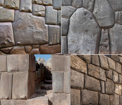
Another remarkable skill some ancient
cultures achieved was that of stone cutting, shaping and dressing. In
fact, around the world, we can find numerous examples of ancient
stone-cutting so precise that they rival creations of the modern day produced
with advanced machinery. One prime example can be found at Puma Punku, along the
Peru-Bolivia border at Lake Titicaca, where 4,500-year-old archaeological site
that contains such incredible stonework that it looks as if the stones were cut
using a diamond tool.
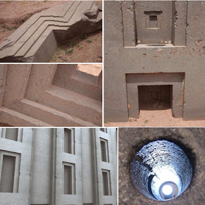
Enormous blocks weighing up to 800
tons, consist of perfectly straight edges that lock perfectly into each other
and contain no chisel marks. Also intricate patterns of very large stones cut
at odd angles that match to form earthquake-proof walls and structures that fit
so precisely together, without mortar, that not even a knife blade or sheet of
paper can be inserted in the joints. All attempts to-date to replicate the
precision of the stonework have failed.
In fact, all of Andean Peru, Ecuador and western Bolivia are well-known for their advanced masonry work, much of which can still be seen today in Machu Picchu, Sacsayhuaman and Ollantaytambo in Peru, or Tiahuanaco in Bolivia. Their large dry stone walls display huge blocks that had been carefully cut to fit together tightly without mortar and with levels of precision unmatched anywhere else in the Americas.
The stones are so closely spaced that a single piece of paper will not fit between the stones. This precision, combined with the rounded corners of the blocks, the variety of their interlocking shapes, and the way the walls lean inward (to prevent damage in the event of an earthquake) have puzzled scientists for decades. The method used to match precisely the shape of a stone with the adjacent stones is still unknown and attempts to recreate the technique have all failed.
 Still another ancient achievement
was the making of concrete. Mormon tells us that the people who went into the
north country “became exceedingly expert in the working of cement; therefore
they did build houses of cement, in the which they did dwell” (Helaman 3:7).
While we do not know exactly what type of cement these Nephites produced, the
Romans about the same time made concrete by mixing lime, volcanic rock, and
seawater for an extraordinarily durable, high-performance composite constructed
from lime and pyroclastic rocks. It is now claimed that this provides a unique
temporal window to address shortcomings in modern concrete longevity and
environmental sustainability.
Still another ancient achievement
was the making of concrete. Mormon tells us that the people who went into the
north country “became exceedingly expert in the working of cement; therefore
they did build houses of cement, in the which they did dwell” (Helaman 3:7).
While we do not know exactly what type of cement these Nephites produced, the
Romans about the same time made concrete by mixing lime, volcanic rock, and
seawater for an extraordinarily durable, high-performance composite constructed
from lime and pyroclastic rocks. It is now claimed that this provides a unique
temporal window to address shortcomings in modern concrete longevity and
environmental sustainability.
Today, scientists studying the composition of Roman concrete, which has been submerged under the Mediterranean Sea for the last 2,000 years, discovered that it was superior to modern-day concrete in terms of durability and being less environmentally damaging.
This was uncovered by an international team of researchers led by Paulo Monteiro of the U.S. Department of Energy’s Lawrence Berkeley National Laboratory (Berkeley Lab), a professor of civil and environmental engineering at the University of California, Berkeley.

The Romans made concrete by mixing
lime and volcanic rock, but underwater, the combination of lime and volcanic
ash with seawater instantly triggered a chemical reaction in which the lime
incorporated molecules into its structure and reacted with the ash to cement
the whole mixture together.
The ancient seawater concrete contains the ideal crystalline structure of Tobermorite, which has a greater strength and durability than the modern equivalent. Analysis of the concrete found that it produces a significantly different compound to modern day cement, which is an incredibly stable binder. Microscopic studies from nanoscale tomography, X-ray microdiffraction, and high-pressure X-ray diffraction synchrotron radiation applications have identified other minerals in the ancient concrete which show potential application for high-performance concretes, including the encapsulation of hazardous wastes.
As an example, conventional modern cement requires heating a mix of limestone and clay to 1,450 degrees Celsius which releases significant amounts of carbon into the atmosphere. In contrast, Roman cement used much less lime and made it from baking limestone at 900 degrees Celsius, requiring much less fuel. “It’s not that modern concrete isn’t good,” Monteiro said of this discovery, “it’s so good we use 19 billion tons of it a year, but the problem is that manufacturing Portland cement accounts for seven percent of the carbon dioxide that industry puts into the air.” He also added, “In the middle 20th century, concrete structures were designed to last 50 years, yet Roman harbor installations have survived 2,000 years of chemical attack and wave action underwater.”
The point is once again that early civilizations had technologies that, in some cases, have yet to be duplicated by modern man, yet so many historians and theorists want to place early cultures, like the Nephites, in a primitive world of non-achievement despite all sorts of testimony to the opposite. As a result, we should be very cautious of any theory that wants to show us that the Nephites and even the Jaredites, were incapable of building far beyond what they want us to believe. Because of this, we should also be very cautious of believing that a Land of Promise without solid, stone-based artifacts of construction like those found in the ancient middle east and Mesopotamia, could possibly be the Land of Promise.
(See the next post, “What about Ancient Technology? – Part III,” for more on the ancient technologies of the Nephite era and where they are found in the Americas)

Left: Adena; Right: Hopewell houses built
during the Nephite era that North American thorists claim were Nephites.
Consider the comparison between this building technique and that of the Hebrews
at Jerusalem from which Lehi came
Obviously, the technology of the ancients was far more advanced than some historians and theorists want to allow. Yet, the scriptural record is replete with their accomplishments. In fact, many sections of the ancient Peruvian road network discussed in the previous post survive today and are still used by pedestrians, especially near such sites as Machu Picchu, where large stone stairways and bridges give access to the site for modern tourists. In addition, some of the original routes have had modern roads built directly over them, illustrating the skills and vision for crossing terrain and distances possessed by the early engineers and road builders.
In addition the Romans were well known as expert road builders. About 1.7 million square miles of territory was covered by the Roman roads, which were made with gravel, dirt, and bricks made from granite and hard lava. Many of their ancient roads are still used today in much of Europe.

Over 2,000 years ago, the
Romans built aqueducts that ran for many miles

Precise cuts and angles of stone cut as though electrical power
equipment was used, but done with chisels and hammers
In fact, all of Andean Peru, Ecuador and western Bolivia are well-known for their advanced masonry work, much of which can still be seen today in Machu Picchu, Sacsayhuaman and Ollantaytambo in Peru, or Tiahuanaco in Bolivia. Their large dry stone walls display huge blocks that had been carefully cut to fit together tightly without mortar and with levels of precision unmatched anywhere else in the Americas.
The stones are so closely spaced that a single piece of paper will not fit between the stones. This precision, combined with the rounded corners of the blocks, the variety of their interlocking shapes, and the way the walls lean inward (to prevent damage in the event of an earthquake) have puzzled scientists for decades. The method used to match precisely the shape of a stone with the adjacent stones is still unknown and attempts to recreate the technique have all failed.

Today, scientists studying the composition of Roman concrete, which has been submerged under the Mediterranean Sea for the last 2,000 years, discovered that it was superior to modern-day concrete in terms of durability and being less environmentally damaging.
This was uncovered by an international team of researchers led by Paulo Monteiro of the U.S. Department of Energy’s Lawrence Berkeley National Laboratory (Berkeley Lab), a professor of civil and environmental engineering at the University of California, Berkeley.

An early Roman concrete method-- Opus incertum is
composed for various rock chunks mixed with cement. Notice that there is no
real brick facing. Opus incertum was one of the earlier concrete construction
methods, like this wall found at Pompeii
The ancient seawater concrete contains the ideal crystalline structure of Tobermorite, which has a greater strength and durability than the modern equivalent. Analysis of the concrete found that it produces a significantly different compound to modern day cement, which is an incredibly stable binder. Microscopic studies from nanoscale tomography, X-ray microdiffraction, and high-pressure X-ray diffraction synchrotron radiation applications have identified other minerals in the ancient concrete which show potential application for high-performance concretes, including the encapsulation of hazardous wastes.
As an example, conventional modern cement requires heating a mix of limestone and clay to 1,450 degrees Celsius which releases significant amounts of carbon into the atmosphere. In contrast, Roman cement used much less lime and made it from baking limestone at 900 degrees Celsius, requiring much less fuel. “It’s not that modern concrete isn’t good,” Monteiro said of this discovery, “it’s so good we use 19 billion tons of it a year, but the problem is that manufacturing Portland cement accounts for seven percent of the carbon dioxide that industry puts into the air.” He also added, “In the middle 20th century, concrete structures were designed to last 50 years, yet Roman harbor installations have survived 2,000 years of chemical attack and wave action underwater.”
The point is once again that early civilizations had technologies that, in some cases, have yet to be duplicated by modern man, yet so many historians and theorists want to place early cultures, like the Nephites, in a primitive world of non-achievement despite all sorts of testimony to the opposite. As a result, we should be very cautious of any theory that wants to show us that the Nephites and even the Jaredites, were incapable of building far beyond what they want us to believe. Because of this, we should also be very cautious of believing that a Land of Promise without solid, stone-based artifacts of construction like those found in the ancient middle east and Mesopotamia, could possibly be the Land of Promise.
(See the next post, “What about Ancient Technology? – Part III,” for more on the ancient technologies of the Nephite era and where they are found in the Americas)
Sunday, April 23, 2017
What about Ancient Technology? – Part I
It is
interesting to note that only a few decades ago, the people of ancient
civilizations were viewed as simple, primitive people. However, numerous
discoveries since then have revealed a number of surprising facts about ancient
cultures, namely that many of them
possessed advanced knowledge of metallurgy, mathematics, chemistry, astronomy,
and more.

With this knowledge they forged
steel stronger than anything else seen until the Industrial Revolution, created
a recipe for concrete so durable that
their buildings would endure for millennia longer than the constructions of
today, cut stones and assembled walls so precisely that attempts at modern-day
replications have failed. Scientists are still scratching their heads
over some of the amazing accomplishments of ancient civilizations.
It should also be noted that such ancient technology was found in and around Jerusalem and Mesopotamia about the time of Lehi, yet none ever showed up in North America in any way. Yet, such has been found in abundance in Andean South America, and to a lesser degree, in Mesoamerica.
Consider, as an example, the art of making steel, which has been criticized for its being mentioned in the Book of Mormon by so many unknowing and ill-informed critics. Over 2,500 years ago, ancient people in the Levant were forging swords made of steel so advanced that blacksmiths would not come close to creating anything of equal quality until modern times. The metal was so strong that the swords could slice straight through objects made of other metals.
The steel, known as Damascus steel, which is a steel made with a wavy surface pattern produced by hammer-welding strips of steel and iron followed by repeated heating and forging, used chiefly for knife and sword blades. While such items were often marketed in Damascus, they were not necessarily made there. According to Arnold Pacey (Technology in World Civilization: A Thousand-year History, MIT Press, 1991, p80), an Associate Lecturer at the Open University in Britain, and author of numerous books published by the MIT Press, Damascus steel was a type used for manufacturing sword blades in the Near East made with wootz steel.

Such steel is a crucible type
characterized by a pattern of bands, which are formed by sheets of micro
carbides within a tempered martensite or pearlite matrix in higher carbon
steel, or by ferrite and pearlite banding in lower carbon steels. It is the
pioneering steel alloy matrix developed in Southern India in the 6th century
B.C. and exported globally. It was also known in the ancient world by many
different names including Wootz, Ukku, Hindvi Steel, Hinduwani Steel, Teling
Steel and Seric Iron, and considered the finest steel in the world.
It was exported as cakes of steely iron
that came to be known as "Wootz, which was widely exported and traded
throughout ancient Europe and the Arab world, and became particularly famous in
the Middle East (Charlotte Speir Manning, Ancient
and Medieval India, Vol 2, Adegi Graphics , 1999).
It might be of interest to know that Dr. Oleg Sherby, Dr. Jeff Wadsworth, and Lawrence Livermore National Laboratory have all attempted to create steels with characteristics similar to Wootz, but without success. J.D Verhoeven and Al Pendray reconstructed methods of production, proved the role of impurities of ore in the pattern creation, and reproduced Wootz steel with patterns microscopically and visually identical to one of the ancient blade patterns. There are other smiths who are now consistently producing Wootz steel blades identical to the old patterns; however, it is not a correct representation of the blades that survive today or the accounts of witnessed methods from antiquity. Not all of the secrets of Wootz have been discovered, but it has essentially been recreated by Anosov, Pendray and many smiths in the 20th century, though research continues (Sharada Srinivasan, "Wootz crucible steel: a newly discovered production site in South India,” Papers from the Institute of Archaeology, University College London (5), 1994, pp49–59).
 Such swords were characterized by
distinctive patterns of banding and mottling reminiscent of flowing water. Such
blades were reputed to be tough, resistant to shattering and capable of being
honed to a sharp, resilient edge, and were produced out of a raw material, imported
from Asia. Other materials were added during the steel's production to create
chemical reactions at the quantum level. It was first used around 600 B.C., but
was produced en masse in the Middle East between 1100 and 1700 AD. The secret
of making modern Damascus steel, has only re-emerged under the inspection of
scanning electron microscopes in modern laboratories.
Such swords were characterized by
distinctive patterns of banding and mottling reminiscent of flowing water. Such
blades were reputed to be tough, resistant to shattering and capable of being
honed to a sharp, resilient edge, and were produced out of a raw material, imported
from Asia. Other materials were added during the steel's production to create
chemical reactions at the quantum level. It was first used around 600 B.C., but
was produced en masse in the Middle East between 1100 and 1700 AD. The secret
of making modern Damascus steel, has only re-emerged under the inspection of
scanning electron microscopes in modern laboratories.
Secondly, consider aqueducts and hydro technology of the ancients, particuarly in Andean South America, where in recent years Peru has been facing a severe water crisis as chronic problems, such as polluted water supplies, and environmental change combine to undermine the water security of the entire country. However, a new plan has been put forward by Lima's water utility company, Sedapal, to “revive an ancient network of stone canals that were built by the very early Peruvian culture in order to supply the population with clean, unpolluted water.”
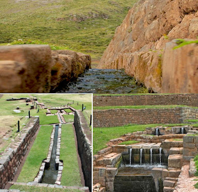 These early Peruvians built an advanced water conservation system
that captured mountain water during the rainy season in canals, which then transported
the water to places where it could feed into springs further down the mountain,
in order to maintain the flow of the rivers during the dry season. Of course, many
ancient civilizations are known for their advanced construction of cisterns,
canals, aqueducts, and water channeling technology, including the Persians,
Nabataeans, Romans, Greeks, Harrapans and many more.
These early Peruvians built an advanced water conservation system
that captured mountain water during the rainy season in canals, which then transported
the water to places where it could feed into springs further down the mountain,
in order to maintain the flow of the rivers during the dry season. Of course, many
ancient civilizations are known for their advanced construction of cisterns,
canals, aqueducts, and water channeling technology, including the Persians,
Nabataeans, Romans, Greeks, Harrapans and many more.
Still another ancient skill that was not re-invented until modern times was the technique of ancient road-building first achieved by the ancient Peruvians as well as the Romans, independently of one another.
Qhapaq Nan, otherwise known as the Main Andean Road in Peru, is a huge network of highways and roads once used by early Andean cultures in Peru long before the Inca came to power, who themselves later used these roads to quickly conquer much of the known western South American peoples. Extending over 25,000 miles, it was the backbone of the Inca Empire's political and economic power, moving their conquering armies quickly into battle across a wide-spread area. Earlier, the roads connected production, administrative, and ceremonial centers of early Peruvian civilization. Extending across what is now Argentina, Bolivia, Chile, Colombia, Ecuador and Peru, these roads had two north-south highways with over 20 other secondary roads, and numerous small branches.
Crossing plains, deserts, and mountains, these well-build roads included bridges, causeways, stairways, and also had small stations and sometimes larger, more luxurious complexes dotted along every twelve miles where travelers could spend the night. Undaunted by geographical difficulties, these early Peruvian engineers built roads across ravines, rivers canyons, sand deserts, high mountain passes, along cliff facings, and mountain edges.

The width of most roads varies from three-and-a-half
to ten feet, although some could be much bigger, such as the fifty feet wide
highway in the Huanuco Pampa province. Sometimes there are also two or three
roads constructed in parallel, especially near the larger urban centers.
Flattened road beds, often raised, were usually made using packed earth, sand,
or grass. The more important roads were finished with precisely arranged paving
stones or cobbles. Roads were typically edged and protected with small stone
walls, stone markers, wooden or cane posts, or piles of stones. Drainage was
provided by frequent drains and culverts, which drew off rainwater from the
road surface, channeling it either along or under the road. When crossing
wetlands, roads were often supported by buttress walls or built on causeways.
Bridges of stone or reeds were also constructed to cover distances in a more
direct route as were large, stone, llama-friendly staircases in mountainous
terrain.
Generally, and despite their reputation for Roman-like long straight roads, these Peruvian roads tended to follow natural contours as the straight stretches of road are rarely more than a mile or two long. It is also noteworthy that Inca roads are very often more elaborate and well-constructed than was actually necessary.
 One of the most impressive fetes and
showcases for ancient Peruvian engineering must have been the many rope
suspension bridges which crossed perilous ravines. These were built using
braids of reed or grass rope with wooden and fiber flooring. Perhaps the most
famous crossed the Apurimac River near Cuzco and measured 150 feet in length.
Suspension bridges were often built in pairs perhaps with one bridge for
commoners and one for nobles. An alternative to such bridges was the oroya,
a suspended basket which transported two or three people at a time over a
greater distance than could be reached with a rope bridge.
One of the most impressive fetes and
showcases for ancient Peruvian engineering must have been the many rope
suspension bridges which crossed perilous ravines. These were built using
braids of reed or grass rope with wooden and fiber flooring. Perhaps the most
famous crossed the Apurimac River near Cuzco and measured 150 feet in length.
Suspension bridges were often built in pairs perhaps with one bridge for
commoners and one for nobles. An alternative to such bridges was the oroya,
a suspended basket which transported two or three people at a time over a
greater distance than could be reached with a rope bridge.
(See the next post, “What about Ancient Technology? – Part II,” for more on the ancient technologies of the Nephite era and where they are found in the Americas)

An ancient Damascus Steel sword
It should also be noted that such ancient technology was found in and around Jerusalem and Mesopotamia about the time of Lehi, yet none ever showed up in North America in any way. Yet, such has been found in abundance in Andean South America, and to a lesser degree, in Mesoamerica.
Consider, as an example, the art of making steel, which has been criticized for its being mentioned in the Book of Mormon by so many unknowing and ill-informed critics. Over 2,500 years ago, ancient people in the Levant were forging swords made of steel so advanced that blacksmiths would not come close to creating anything of equal quality until modern times. The metal was so strong that the swords could slice straight through objects made of other metals.
The steel, known as Damascus steel, which is a steel made with a wavy surface pattern produced by hammer-welding strips of steel and iron followed by repeated heating and forging, used chiefly for knife and sword blades. While such items were often marketed in Damascus, they were not necessarily made there. According to Arnold Pacey (Technology in World Civilization: A Thousand-year History, MIT Press, 1991, p80), an Associate Lecturer at the Open University in Britain, and author of numerous books published by the MIT Press, Damascus steel was a type used for manufacturing sword blades in the Near East made with wootz steel.

An ancient legendary Uifberht blade made from crucible Wootz steel
It might be of interest to know that Dr. Oleg Sherby, Dr. Jeff Wadsworth, and Lawrence Livermore National Laboratory have all attempted to create steels with characteristics similar to Wootz, but without success. J.D Verhoeven and Al Pendray reconstructed methods of production, proved the role of impurities of ore in the pattern creation, and reproduced Wootz steel with patterns microscopically and visually identical to one of the ancient blade patterns. There are other smiths who are now consistently producing Wootz steel blades identical to the old patterns; however, it is not a correct representation of the blades that survive today or the accounts of witnessed methods from antiquity. Not all of the secrets of Wootz have been discovered, but it has essentially been recreated by Anosov, Pendray and many smiths in the 20th century, though research continues (Sharada Srinivasan, "Wootz crucible steel: a newly discovered production site in South India,” Papers from the Institute of Archaeology, University College London (5), 1994, pp49–59).

An
ancient Damascus steel short sword with an unusual distinctive bone handle
(made for an ancient Middle East sheik)
Secondly, consider aqueducts and hydro technology of the ancients, particuarly in Andean South America, where in recent years Peru has been facing a severe water crisis as chronic problems, such as polluted water supplies, and environmental change combine to undermine the water security of the entire country. However, a new plan has been put forward by Lima's water utility company, Sedapal, to “revive an ancient network of stone canals that were built by the very early Peruvian culture in order to supply the population with clean, unpolluted water.”

Still another ancient skill that was not re-invented until modern times was the technique of ancient road-building first achieved by the ancient Peruvians as well as the Romans, independently of one another.
Qhapaq Nan, otherwise known as the Main Andean Road in Peru, is a huge network of highways and roads once used by early Andean cultures in Peru long before the Inca came to power, who themselves later used these roads to quickly conquer much of the known western South American peoples. Extending over 25,000 miles, it was the backbone of the Inca Empire's political and economic power, moving their conquering armies quickly into battle across a wide-spread area. Earlier, the roads connected production, administrative, and ceremonial centers of early Peruvian civilization. Extending across what is now Argentina, Bolivia, Chile, Colombia, Ecuador and Peru, these roads had two north-south highways with over 20 other secondary roads, and numerous small branches.
Crossing plains, deserts, and mountains, these well-build roads included bridges, causeways, stairways, and also had small stations and sometimes larger, more luxurious complexes dotted along every twelve miles where travelers could spend the night. Undaunted by geographical difficulties, these early Peruvian engineers built roads across ravines, rivers canyons, sand deserts, high mountain passes, along cliff facings, and mountain edges.

A road built along a high cliff face. In the middle (center arrow) the
road had removable wooden planks that could be pulled aside in order to keep an
invading army or force from advancing along the cliff road
Generally, and despite their reputation for Roman-like long straight roads, these Peruvian roads tended to follow natural contours as the straight stretches of road are rarely more than a mile or two long. It is also noteworthy that Inca roads are very often more elaborate and well-constructed than was actually necessary.

(See the next post, “What about Ancient Technology? – Part II,” for more on the ancient technologies of the Nephite era and where they are found in the Americas)
Subscribe to:
Posts (Atom)


