Wednesday, August 31, 2016

Textual Changes in the Book of Mormon – Part I


So much has been said and written by both adherents and critics to the Book of Mormon, including several articles we, ourselves, have added, that perhaps another article on the subject is a bit redundant; however, the subject keeps circulating, especially among the critics and the uninformed, that cause some difficulty for trusting members regarding the accuracy of the Book of Mormon.
    First of all, there were two manuscripts. The first was the original manuscript—the text written down by scribes as Joseph Smith translated the Book of Mormon. Most of this manuscript has been destroyed over time by mold and water seepage. Only 28 percent of the original is extant. The printer's manuscript—the handwritten copy that was made to take to the printer for typesetting.
The printer’s manuscript of the Book of Mormon, like the original, was written without punctuation 

    Most every member knows that Joseph Smith, of course, translated the scriptural record, but not everyone knows that the spelling in the first edition was that of Oliver Cowdery, and the punctuation was that of the chief compositor, John H. Gilbert, the non-Mormon typesetter who worked for E. B. Grandin, publisher of that edition. When the text was first delivered for printing, it was “found that the manuscript was closely written and legible, but not a punctuation mark from beginning to end,” Gilbert later wrote.
 Façade of the Grandin print shop on Main Street in Palmyra, New York, after being restored by the Church. The Book of Mormon was first published here in 1830 

    It might be of interest to know that five-sixths of the 1830 Book of Mormon was set from the specially prepared copy of the original manuscript, called the printer’s manuscript, which was standard practice of the day, however, one-sixth (from Helaman 13:17 to the end of Mormon) was set from the original (dictated) manuscript—the copy prepared specifically for the 1830 typesetter to use as his copytext. The reason for the switch was the need to take the printer’s manuscript to Canada in February 1830 in order to secure the copyright of the Book of Mormon within the British empire. During the time that Oliver Cowdery and others were on their trip to nearby Canada with the printer’s manuscript, the 1830 typesetter used the original manuscript to set the type, although he himself was unaware that there had been a temporary switch in the manuscripts (According to Stephen Ehat’s discussion of Joseph Smiths efforts in early 1830 to get the copyright of the Book of Mormon secured in Canada; BYU Studies, volume 50, number 2, pages 4-70).
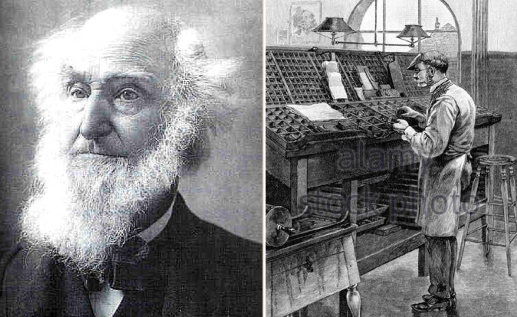
(Left:) John H. Gilbert, Jr., in 1890, stating in recollection: “I punctuated it to make it read as I supposed the Author intended, and but very little punctuation was altered in proofreading; (Right) The work of a compositor or typesetter in the early days of printing 

    “According to Gilbert, it was Hyrum Smith who brought the first twenty-four pages of the handwritten printer’s manuscript to the publisher. As the compositor said:
    “He had it under his vest, and vest and coat closely buttoned over it. At night [Hyrum] came and got the manuscript, and with the same precaution carried it away. The next morning with the same watchfulness, he brought it again, and at night took it away. On the second day—[Martin Harris] and [Hyrum] being in the office—I called their attention to a grammatical error, and asked whether I should correct it? Harris consulted with [Hyrum] a short time, and turned to me and said: ‘The Old Testament is ungrammatical, set it as it is written.”
    After working in that manner a few days, Gilbert suggested to Hyrum when being given the manuscript for the day’s work: “Mr. Smith, if you would leave this manuscript with me, I would take it home with me at night and read and punctuate it.” Hyrum replied to this: “We are commanded not to leave it.” A few mornings after this, when [Hyrum] handed me the manuscript, he said to me: ‘if you will give your word that this manuscript shall be returned to us when you get through with it, I will leave it with you.’”
    For two or three nights Gilbert took it home and punctuated it with a lead pencil” resulting in Gilbert’s effort of somewhere between 30,000–35,000 additional punctuation marks (Wilford C. Wood, Joseph Smith Begins His Work, vol. 1, Salt Lake City: Wilford C. Wood, 1959).
    Typesetting from the Oliver Cowdery’s handwritten (copy) printer’s manuscript commenced in August of 1829 and by March of the following year was completed—a little over six-and-a-half months. During this time, Joseph Smith had had little to do with the supervision of the printing for the first edition, being in Grandin’s printshop only once for about fifteen minutes during that time.
The time-line for the 1829-30 edition of the Book of Mormon—as Oliver Cowdery described these early days: “Days never to be forgotten—to sit under the sound of a voice dictated by the inspiration of heaven, awakened the utmost gratitude in this bosom! Day after day I continued, uninterrupted, to write from his mouth, as he translated with the urim and thummim”

    As soon as the first edition was out, readers began finding typographical, spelling, and grammatical errors. On 25 June 1833, Joseph wrote to printer W. W. Phelps, “As soon as we can get time, we will review the manuscripts of the Book of Mormon, after which they will be forwarded to you.” (HC, 1:363.)
    With the help of Oliver Cowdery, the Prophet prepared the second (1837) edition. At this point, they made over one thousand corrections—most of them grammatical and added some minor clarifications. By this time, the Prophet, who had limited formal schooling, was learning the rudiments of Hebrew, and English grammar. (HC, 2:390, 474; 3:26.)
    Both the 1840 and 1842 editions were carefully revised by Joseph Smith. By now, however, Oliver Cowdery had left the Church, taking the printer’s manuscript with him.
    As late as 15 January 1842 Joseph Smith was still making corrections himself. He recorded: “I commenced reading the Book of Mormon, at page 54, … (the previous pages having been corrected), for the purpose of correcting the stereotype plates of some errors which escaped notice in the first edition” (HC, 4:494.)
    Because the first European edition in English followed the 1837 edition, it did not contain some of these changes made by Joseph Smith. So later American editions, which were taken from the first European edition, perpetuated these omissions.
The printing press on the third floor of the E.B. Grandin Building on Main Street in Palmyra, New York, where the Book of Mormon was first published in 1830

    John Taylor assigned Orson Pratt to prepare a new edition of the book in 1879. Elder Pratt redivided the chapters (increasing them from 114 to 239)—and added verse numbers and references. After the turn of the century, President Heber J. Grant called James E. Talmage to prepare a new edition. The 1920 edition included double-column pages, revised references, a pronouncing vocabulary, an index, and many grammatical improvements. And, most recently, the 1981 edition was prepared under the supervision of the Scriptures Publication Committee, under direction of the First Presidency.
(See the next post,” Textual Changes in the Book of Mormon – Part II,”for more on the early editions of the Book of Mormon).

Tuesday, August 30, 2016

More Comments from Readers – Part V


Here are more comments that we have received from readers of this website blog: 
    Comment #1: “Who or what was the Sapa Inca?” Bill S.
    Response: The ultimate head of all Inca rule was the Sapa Inca. Sapa means “only” or the “Only Inca.” During the golden years of the empire, 1438 to 1533, there were only three Great Sapa Incas: Pachacutec (also called Pachacuti), who ruled from 1438 to 1471; Tupac Inca Yupanqui, who ruled from 1471 to 1493; and Huayna Capac (pronounced WHY-nuh CA-poc), who ruled from 1493 to 1525. The warring half-brothers Huáscar and Atahuallpa (pronounced AH-tah-WAHL-pah) were also Sapa Incas who ruled, though briefly during a Civil War, before the Spanish conquest in 1533. 
    The Sapa Inca was considered a descendant of Inti, the sun god, and therefore was regarded as a semi-divine (godlike) being. He held authority over all things. Upon taking power, the Sapa Inca married one of his sisters to keep the royal bloodline purely Inca. The Sapa Inca's sister/wife, also known as his principal wife, was called the coya, or queen. Sapa Incas had many other wives as well, and sometimes Sapa Incas had hundreds of children. However, only the sons of the principal wife were eligible to inherit the Sapa Inca's position. The Sapa Inca considered the worthiness of each of these sons before choosing a successor; succession to the throne was not a matter of birth order.
During the years of Inca dominance, the position of Sapa Inca was surrounded by symbols and rituals. The Sapa Inca wore a braided headband with red tassels wrapped several times around his brow and carried a special gold club. When he traveled, he was carried upon an immense litter (an enclosed platform, usually borne on the shoulders of servants), accompanied by a multitude of servants and attendants. Also in this large traveling group were the many wives of the Sapa Inca and some of their children. The wives walked closest to the Sapa Inca and provided a buffer between him and all the other people.
    Everyone treated the Sapa Inca with extreme ceremonial reverence. When people needed to speak to the Sapa Inca, they would approach him barefoot and with a heavy load on their back as a sign of humility. They were required to look at their feet—never into his eyes—and often one of his wives would hold a cloth screen across his face so that it was impossible for anyone to look upon the Sapa Inca directly. No one except his wives was allowed to touch any clothing he had worn, and his wives periodically burned his used clothing to ensure this. The leftovers of the Sapa Inca's meals were also burned. If the Sapa Inca wished to spit, one of his wives would hold out her hand so he could spit into it. If a hair fell from his head, a wife would quickly eat it so that no one would ever be able to touch it. The Incas feared that if others had access to articles that had been close to, or part of, the Sapa Inca, such items could be used to put an evil spell on him.
    The divine role of the Sapa Inca continued after his death, and so did his reverential treatment. His relatives had the body mummified, and then all of them except for the successor to the throne continued to live in the Sapa Inca's palace, using his vast stores of wealth; the household of the dead Sapa Inca was called the panaca. Meanwhile, the Sapa Inca's successor had to go out and build a new palace and find new sources of food and goods to supply it. Even after the new Sapa Inca ascended the throne in his own palace, the deceased Sapa Inca was treated as if he were still alive and ruling the empire. During festivals and ceremonies the various panacas of all the deceased Sapa Incas brought out the sacred mummies and sat them together on a platform. They even fed the mummies and gave them chicha (beer made from maize) to drink.
Further, in the Inca homeland, the people next in line to the Sapa Inca were the other Incas, who had the top privileges of the kingdom. They were entitled to live in the center of Cuzco with their servants, and they sent their children to special schools. Incas were later called orejones, meaning "big ears" in Spanish, because only Incas were entitled to wear prestigious earplugs, large, ornamental tube-shaped studs that were fitted into a hole in their earlobes.
    In addition, there was a distinct hierarchy (or ranking) among the Incas. The most powerful people were those closely related to the Sapa Inca. Next in line were the Incas who were not closely related to the Sapa Inca. (Though it was believed that all Inca nobility stemmed from the same families, though over the years some of the blood relations had become distant). As the Incas acquired more territory, they found it necessary to give noble ranking to a third group of non-Inca people. These were known as Incas-by-privilege, and though they were not Incas by birth, they were Quechua-speaking people who had lived in the Cuzco area for a long time. The Incas added this group to their elite because even though an Inca man could have many wives, the Incas could not produce enough offspring (Incas by blood) to manage the entire empire by themselves.
    Comment #2: “One would think that if Pachacamac was actually Zarahemla, that there would be a lot of evidence of the type of living there found in the record, one of those that come to mind is when it talks about Zarahemla with their fine silks, and their fine-twined linen. Is there any evidence of this in Pachacamac?” Lindsey P.
    Response: It is interesting that you should ask since weaving, twining, embroidery and other textile remnants have been found along the south coast where the greatest amount of material is available for study of textile art and development. In this almost perfect arid region the site of preservation of the fabrics is remarkable and the known quantity is very great and most importantly, “the technical and artistic quality extraordinary.”
In fact, “while twining and weaving were contemporary throughout the pre-ceramic period, it is curious that weaving remained subordinate to twining for so long.” The earliest known weavers of the southern coast, those of the Paracas period (800 B.C. to 100 B.C.) as well as those of the later Nazca Valley (100 B.C. to 450 A.D.), practiced every important fundamental technique known in the latest periods, especially “for their technically complex textiles” (Helaine Silverman and Donald A. Proulx, The Nasca, Blackwell Publishers, Malden, 2002). According to Mary Frame's extensive analysis of textiles has revealed more about the women, that “although they are rarely recognized in the archaeological record, they had ready access to high-status materials and the right to wear potent imagery on their garments, which gave an indication of their status” ("What the Women Were Wearing,” Textile Museum Journal, Vol 42-43, 2003/04,13–53). 
    Comment #3:  “I love your explanation of the scriptures. You make them come alive with sound, reasonable, and very supportable views. Thank you” Carma C.
    Response: Thank you. 
    Comment #4: “Do we know the size of the Temple in Zarahemla?” Regina Y.
    Response: Pachacamac covered about 12 acres in area, and rose to about 75-feet. It was isolated from the rest of the city complex and sat atop a hill overlooking the Pacific coast. Later temples and complexes were built more within the city site itself, for these early temples, such as Cuzco (City of Nephi) and Pachacamac (Zarahemla) were more isolated. The overall city complex covers about 210 acres (85 hectares).

Monday, August 29, 2016

More Comments from Readers – Part IV


Here are more comments that we have received from readers of this website blog: 
    Comment #1: “To wonderboy's point, "both" is commonly used to list three or more things (both men, women and children). One example is Ether 10:12 "...and the people became exceedingly rich under his reign, both in buildings, and in gold and silver, and in raising grain, and in flocks, and herds, and such things which had been restored unto them." Just an observation” Tyrus. 
    Response: We have dealt with this several times before, so let's try it from this angle: First: “both gold, silver and copper” is correct only because it separates “gold and silver” as one type of item (precious metals) and “copper” as a second type of item (non precious metal); the same is true of “both men, women and children, i.e., “men and women” as adults, and “children” as non-adults. In both cases, the term both is used correctly. On the other hand, to say “In my salad they put both Cucumbers, Avocado and Sweet Peppers,” is incorrect since all three are fruits and is the misuse of the word “both,” while “In my salad they had both tomatoes, eggplant and lettuce” would be correct, since tomatoes and eggplant are fruits, and lettuce is a leaf vegetable.
    As for Ether 10:12, this is not a list as the others are, i.e., of gold and of silver and of copper (of men and of women and of children), but a sentence structure that lists "the people became exceedingly rich under his reign, [both in buildings and in gold and silver], the rest follow under his reign: and (also) in raising grain, and in flocks, and herds, and such things which had been restored unto them. One is a determiner and the other is a predeterminer. Of course you could also make the case that buildings, gold and silver are physical, non living items, while grain, flocks and herds are living and eatable items.
    I also beg to differ with you in "both is commonly used to list three or more things," actually, the opposite is true. In American English both is used to mean as an adjective: “One and the other; relating to or being two in conjunction” also as a Pronoun: “Both indicates that the action or state denoted by the verb applies individually to each of two entities” also as a conjunction: “Used with and to indicate that each of two things in a coordinated phrase or clause is included.” 
Which image would you not use the word “both” with? 

    As stated in various English grammar rules: “Both refers to one and the other; two together; the one as well as the other; the two; two considered together. “if you want to emphasize that what you are saying is true of two things or people, you put both in front of the first of two noun phrases.” Or “you can put both in front of the first of two adjectives, verb phrases, or adverbials.” “The phrase after both should be of the same type as the phrase after and.” “You can put both immediately in front of a single noun phrase when it refers to two people or things.” Under Adjective; “both (used with count nouns) two considered together, the two: as in “both girls are pretty.” 
    Under “Caution: Don't use 'both' to talk about more than two things or people. Instead you use all.” 
    Since both is defined ancient and today as meaning "two" and is never followed by three or more items in correct English, though it may be found in some cases, it is not proper English. Both means two. In Hebrew, the word for both is “yachad” (pronounced “Yakh’-ad”), שני (Shin Nun Yod), which means “a unit together, both” and used as we use “both,” also means “two united, each other, and used to combine two items, though one may be greater than the other,” as in “God and man (we) together” used in scripture for “they perished together” “in place and time at once” “all together” “the clean and the unclean” “the ox and the donkey” “the gazelle and the deer” “dwell together as one” “a man and his countryman” “alike, the one as well as the other”
    Comment #2: “You seem to be able to answer any question, and I have always wondered what it means when Moses told the Lord he was “slow of tongue” Jaylynn O.
    Response: Actually, Moses said he was “slow of speech, and of a slow tongue” (Exodus 4:10), which has a meaning probably not what most people think. First of all, “slow of speech” literally means “heavy of mouth” which in turn defines someone who is not comfortable or confident in speaking; while “of a slow tongue” literally means having a “heavy tongue” which, in turn means having difficulty with a foreign language or with language all together.
    When the Lord wanted Eziekel to go preach to the House of Israel, the prophet was reluctant, not feeling up to the task and the Lord said to him: “For thou art not sent to a people of a strange speech and of an hard language, but to the house of Israel. Not to many people of a strange speech and of an hard language, whose words thou canst not understand. Surely, had I sent thee to them, they would have hearkened unto thee” (Ezekiel 3:5-6). When the Lord was telling Moses to return to Egypt, Moses was not concerned about any problem with any defective articulation, but in his inability to take command his Hebrew and former Egyptian languages.
Moses had commanded the Egyptians and was mighty in words and deeds 

    To more fully appreciate this exchange between the Lord and Moses, we have to keep in mind that 40 years earlier Moses was not slow of speech and fully confident in his abilities: as stated in Acts, Moses was learned in all the wisdom of the Egyptians, and was mighty in words and deeds” (Acts 7:22). But for the 40 years in Midian, Moses had been speaking mostly to sheep as a herdsman. No longer was he addressing with eloquence the throngs of Egyptians in their mighty courts and halls and no doubt had lost much of his earlier speaking ability—at least the confidence of such in his own mind. 
    The fact that Moses thought himself not eloquent was probably a prideful thought based on the fact that he had once commanded great attention with his speech. It can be deflating to have once been the focal point of command of language and then fall to a point where one loses confidence in that command and asked to go before people who had once known his eloquence. Even though the Lord was not sending Moses, anymore then he was Eziekiel, to a foreign land where they spoke a foreign language, but to the House of Israel. It seems, at least in this early stage of his calling, Moses was more reluctant than fearful—after all, he had once felt far superior to the Israelite slaves, and Master to a certain degree as the son of the Pharaoh to their overseers.
The Lord gave Moses his brother Aaron to speak for him when they were before the Pharoah of Egypt 

    The point is, Moses was unwilling, not unable, which is probably true with many good people who the Lord calls or wants to call to his service. Rather, he would have us willing and unable, since he can add to our abilities to any degree he needs and chooses. A lesson to learn from this might be that when we are unwilling, the alternate choice of the Lord might not be in our own best interest—take Moses, who was given Aaron to speak for him, yet later on created the Golden Calf which altered the course of Israelite history.

Sunday, August 28, 2016

More Comments from Readers – Part III


Here are more comments that we have received from readers of this website blog:
    Comment #1: “Where did the name Mulek come from? I thought MLK “Mulek” just meant “king” Wesley G.
When Mulek was spirited away from the palace and Jerusalem, he likely would have been a small child or even baby in the care of servants and the palace retinue 

    Response: An excellent question. We use Mulek for convenience sake, however, it is really not a name but a station designation—“king.” Or, more accurately, as a diminutive term of endearment meaning  “Little King,” since the actual name “Mulek” is a nickname derived from Melek. Its longer form occurs in the Bible as Malkiyahu (English: Malchiah), meaning “Jehovah is king,” who was the son of Hammelech (Jeremiah 38:6); however, in reality, this must have been a mistranslation, since ben-hamnmelek means “son of the king,” and is not a proper name (Septuagint LXX Jer. 45:6). 
    According to Aharon, p22), Zedekiah had a son named Malkiyahu and that the familial forms of yahu-names were shorter than their full forms. As an example, the seal of the scribe of Jeremiah showed his full name as Berechiah (English: Berechiah), although the biblical text uses only the shorter Baruch. This is consistent with viewing the hypocoristic Mulek as the diminutive of Malkiyahu, since a is often assimilated to o or u in the vocalic structure of most Semitic languages. It is therefore possible that the Mulek of the Book of Mormon is "Malchiah, son of the king" mentioned in Jeremiah 38:6).
    This leads to two possible answers in regard to the actual name: 1) Mulek in the scriptural record, as the surviving son, may have taken on the name Mulek (king), a title which was his by inheritance; or 2) The name simply was used in its diminutive form of endearment since Mulek would have been very young when leaving Jerusalem and might have been called “Little king” by those who spirited him out of the palace and out of Jerusalem—and the name stuck. A third possibility is that the Zarahemlanites (Mulekites) may simply have evolved that name down over time from its proper name of Malkiyahu or Malchiah. It is one of those questions to which we likely will never know the correct answer.
    Comment #2: “I have read a lot of different views of the land of promise and I must tell you that yours is the only one that truly makes any sense. It is well written, well thought out, very informative, and extremely well supported” Joseph C.
    Response: Thank you for your kind words.
    Comment #3: “It’s too bad we don’t know very much about the Nephites after Nephi and Jacob died until Mosiah led the Nephites out of the city of Nephi to discover Zarahemla. In all your studies have you discovered anything of interest?” Jayson M.
Enos, the son of Jacob, and father of Jarom, was a righteous man 

    Response: While Jarom, Jacob’s grandson through Enos, wrote very little, he had a lot to say which is often skipped over by the casual reader of the scriptural record. Around 400 B.C., after being in the Land of Promise and separated from the Lamanites for about 180 years or so, the Nephites had developed a sizable population (Jarom 1:5). Jacob began recording his record in 545 B.C., the year before Nephi dies. And it is likely being at least 25 years younger than Nephi, that he died somewhere around 490 B.C.
    Jacob’s son, Enos, was aging by 421 B.C. and near the end of his life (Enos 1:25). During his life the wars with the Lamanites seem to have intensified for there were a great many contentions and wars and destruction in the time of Enos (Enos 1:23), and by the time of Jarom, Enos’s son and Jacob’s grandson (great grandson of Lehi), the Nephites had become a stiffnecked people leading him to write: “it is expedient that much should be done among this people, because of the hardness of their hearts, and the deafness of their ears, and the blindness of their minds, and the stiffness of their necks; nevertheless, God is exceedingly merciful unto them, and has not as yet swept them off from the face of the land (Jarom 1:3), yet there were still a certain number of righteous Nephites that received revelations, had faith and communion with the Holy Spirit (Jarom 1:4), it might even be that the Nephites were experiencing a renaissance or rebirth of the Spirit, for by 400 B.C., the Nephites were living the Law of Moses, keeping the Sabbath day holy, profaned not and neither did they blaspheme, and they were keeping the laws of the land which were exceedingly strict (Jarom 1:5).
    While the Nephites were increasing in number and scattered upon much of the face of the land, as were the Lamanites, the Lamanites far exceeded the number of Nephites (Jarom 1:6). This led to an increase in wars--showing the intenwity to which the Lamanites hated the Nephites over the false assumption and lies that Nephi had stolen the birthright and though at this period of time it mattered little, the Lamanites were very willing to accept it as a reason to wipe out the Nephites (it is not unlike the Arab's attitude toward the Jews of Israel today). 
    During this time,  the Nephites were blessed with strong and mighty leaders and kings in the faith of the Lord, leading the Nephites to victories and driving out the Lamanites (Jarom 1:7), which led to the Nerphites fortifying their cities throughout the land of their inheritance (Jarom 1:7). And they “multiplied exceedingly, and spread upon the face of the land, and became exceedingly rich in gold, and in silver, and in precious things, and in fine workmanship of wood, in buildings, and in machinery, and also in iron and copper, and brass and steel, making all manner of tools of every kind to till the ground, and weapons of war” (Jarom 1:8).
    Evidently, at this time as the third century B.C. began, the Nephites were living the commandments and the Lord was prospering them in the land (Jarom 1:9), as Church leaders labored diligently, exhorting with all long-suffering the people to diligence, teaching the law of Moses and the intent for which it was given, persuading them to look forward unto the Messiah and believe in him to come as he though he already had (Jarom 1:11). By 238 years from the time Lehi left Jerusalem (362 B.C.), which is about the time that he handed the plates over to his son, Omni (Jarom 1:15).
    In all of this we find a people living the commandments and striving to do right and the Lord blessing them in their endeavors, both temporally and spiritually. It is also at this time that we can assume that the Nephites expanded their holdings, building new cities, roads, and spreading furhter over the land. In fact, within another 38 years, “the more wicked part of the Nephites were destroyed” (Omni 1:5); however, the Lamanites evidently stepped up their attacks (Omni 1:10), at which time the Lord warned Mosiah to leave the city of Nephi, which was somewhere around 205 B.C.
During all those years, it is obvious that the Nephites built many cities, even roads within their general area (yellow area on map known as the Land of Nephi—Alma 22:28) of the original Land of Nephi, a much smaller area than it later became (white area known as the Land of Lehi—Helaman 6:10) after Mosiah resettled the Nephites in Zarahemla. The yellow area, which covers the land from just south of Lake Titicaca (including Tiahuanaco and Puma Punku) to the area of Cuzco (city of Nephi), with Pachacamac, just south of Lima (city of Zarahemla).
    Comment #4: “Why do you insist that Ripliancum was the Sea north. No one else thinks that—they think it was a lake, or a river” Rita G.
    Response: Ripliancum, which interpreted means “large, to exceed all,” seems like an odd name to give a river or a lake. What would “exceed all” mean? We are dealing with the term “waters” here—the Waters of Riplianum, meaning “the Waters that Exceed all.” All what? Normally, when an abridger gives us an explanation of an unknown word, there is a reason behind it—such as Nephi’s “Irreantum” meaning “many waters. In the northern lands of the Jaredites, Mormon elsewhere uses the term “Land of Many Waters, rivers and fountains,” to suggest the kind of land in which the final battle took place. Here Moroni tells us that the Jaredites were battling in the land far to the north, around an area of exceedingly large waters, so large, their name means “to exceed all.” Sounds like more than a river or lake to me. More like an ocean—i.e., the Sea North. This is especially valid since it occurred long before the destruction mentioned in 3 Nephi and that, according to Jacob and Nephi, they were on an island, what other water to exceed all would there be except the Sea to the North?

Saturday, August 27, 2016

More Comments From Readers – Part II


Here are ore comments from readers of our blog:
    Comment #1: “I read somewhere that the waters of Sebus in the Land of Nephi were probably Lake Titicaca” Pen F.
    Response: This is highly unlikely. The Waters of Sebus would have been a fresh water lake or pond of some type, but certainly not the salt water of Lake Titicaca, which once rested at sea level and was part of the inland ocean (Sea East) before the full continent rose. Today, Titicaca is considered a fresh water lake, but that is because the high content of the original lake has drained to the south, forming the ancient Lake Poopo, which in turn formed part of the many salt flats beyond, the major one called Satlar de Uyuni, which is the world’s largest salt flat.  The legacy of this prehistoric area is legend when the trapped lakes rose up from sea level within the land of the continent as it rose forming the Andes and the Amazon Basin.
When this area went dry, it left behind a desert-like, 6835-square-mile landscape of bright-white salt, rock formations and cacti-studded islands. Its otherworldly expanse can be observed from central Incahuasi Island. Though wildlife is rare in this unique ecosystem, it does harbor many pink flamingos. Poopo lake itself once received its water from Titicaca via the Desaguadero River, but it was never deep (about 10-feet) and eventually much of it dried up, sending its saline content out over the desert floor creating many salt deposit flat areas. This is easily seen from an aerial view of Titicaca which shows its various drainage arms once fed the Altiplano to the south and various small lakes where Poopo is now located and are now part of the salt flats.
    Even today, Titicaca has a high salt content that is above normal for a fresh water lake. In the time of the sons of Mosiah, about 91 to 77 B.C., Titicaca had not yet risen up to its present height as a result of the earthquakes and destruction and rise of the mountains “whose height is great” (Helaman 14:23). Consequenty, it would not be possible for Lake Titicaca to be the Waters of Sebus.
Comment #2: “I know you have addressed this a few times, but I find it hard to believe you can think that something written down by Frederick G. Williams on a scrap of paper was a prophecy” Candice F.
    Response: First of all, it was not a scrap of paper as Mesoamericanists like to so glibly claim, but a sheet of paper on which at least one other prophecy had been written, plus some other matters dealing with his position as 2nd Counselor in the First Presidency and personal scribe to Joseph Smith. Secondly, I have no idea if it was a revelation or not, and to me that is not the issue. If it was a revelation, great. But the fact that it was not published suggests it was not a prophecy—or at least was not meant to be announced to the Church as one. Actually, the note’s main value is in the fact that it mentions a sailing course that matches the winds and currents southward from the south coast of the Arabian Peninsula, all the way to the claimed landing site of Lehi at 30º south latitude on the west coast of Chile in South America. It is amazing to me that Williams, and whether Joseph Smith and Sidney Rigdon discussed it or not, though one might think it was a topic of conversation being written on the sheet of paper that was part of a Presidency Meeting on the other points written upon it, the position at 30º south latitude, where the Bay of Coquimbo is located and La Serena, is a very remarkable place to choose as the landing site.
In 1830, the U.S. had only 24 states, Mexico controlled Most of the west the Louisiana Purchase area was open territory, Spain controlled Florida, Michigan Territory, Arkansas Territory, and the Oregon Territories were owned by the U.S., and Russia owned Alaska—the United States had no access to the Pacific Ocean 

    This is partially because if anyone knew anything about South America at the time in the 1830s-1840s in the backwoods of western New York, it would have been further south around Santiago where the bay there would have been much better known. However, Williams wrote down the site that is Coquimbo Bay, relatively unknown to the American navy until much later in the 1800s, and not known for some other very important information until the 20th century, namely:
Coming up from the south, Nephi’s ship would have been slowed by the winds and currents which die down at 30º and allow him to steer out of the current and into the bayh—he would have landed somewhere within the yellow box 

1. The Mediterranean Climate, only one of five outside the Mediterranean Sea boundary, only one of two in the Western Hemisphere, and the only place in the world where in 600 B.C. seeds from Jerusalem would have grown outside the location where they were first grown—and they grew exceedingly and provided an abundant crop;
2. An immediately place to pitch tents where a fresh water river flowed, the bay protected the climate, where seeds could be planted and where Lehi could live out his remaining days without having to travel inland in search for a place to settle down;
3. A vast forest nearby (actually very close, bordering upon La Serena) where wild and domestic beasts and animals could exist after hundreds of years in proximity;
4. Where gold, silver and copper was found along the surface and in great abundance.
    All of this is found in 1 Nephi 18:23-25.
    Commodore Oliver Hazard Perry around Lake Erie in 1813 during the War of 1812 and the Battle of Put-in-Bay off the coast of Ohio. Williams’ profession was as a doctor, having grown up since the age of 12 in a frontier house in Cleveland, Ohio, and his father owned and operated a flour mill and a saw mill. As the eldest child, much was expected of Frederick. He worked on his father's farm and mills, helped construct their new home on a bluff overlooking the bay, and took over the care of the younger children and other household duties as his mother gradually lost her eyesight.
    During the War of 1812, Cleveland became an important military station.
Commodore Oliver Hazard Perry defeated the British in the Battle of Lake Eire. A Captain at the time, Perry’s defeat of the british was the first unqualified defeat of a British naval squadron in history. Perry, age 28, led a U.S. fleet of nine American ships to victory over a squadron of six British warships at the Battle of Lake Erie in 1813 during the War of 1812 
    Commodore Perry came in 1813 to build the ships which regained control of the Upper Lakes Region from Barclay's English fleet. Frederick, twenty-six, joined Perry as a pilot, directing him around the Lake region. After Perry's victory on Lake Erie and General Harrison's victory on land, the war came to an end so far as the Cleveland area was concerned. Frederick began teaching school and continued to work as a pilot on Lake Erie, transporting goods and passengers between Buffalo and Detroit. He married, worked as a doctor, and was converted to the Church  by missionaries Oliver Cowdery Parley P. Pratt, Ziba Peterson, and Peter Whitmer, Jr. 
    There is nothing in Williams’ experiences and background to suggest he knew anything about the deep ocean, South America, or winds and currents of the sea other than Lake Erie. Yet, out of the blue, Williams picked a location to land which was one of a handful of places along a 2500 mile coastline where landing would have been possible, the only one where Lehi’s Jerusalem seeds would have grown, and that matched perfectly Nephi’s description of their landing on the promised land. The chance of that occurring have to be several million to one. It would be like you naming a location for a moon landing back in 1960, before the space program even began when President Kennedy said they were going to put a man on the moon. 
First Presidency Meeting: LtoR Sidney Rigdon, 1st Counselor; Joseph Smith (standing); and Frederick G. Williams (2nd Counselor 
    Yet the importance of this has been lost on the numerous Theorists who argue over whether it was a prophecy or not, lose sight of the real importance of this written sentence and the environment in which it was involved, with Rigdon and the Prophet, Joseph Smith.

Friday, August 26, 2016

More Comments From Readers – Part I


Here are more comments and questions from our readers of this blog:
    Comment #1: “You seem to have settled on the idea that the Gulf of Guayaquil is the area that separated the Land Northward from the Land Southward creating a narrow neck of land in between. Is there no other area where this neck could be? Potter thinks he found an area much further south in the Lurin Valley. What do you think of his location?” Link O.
    Response: Potter’s area is not a location that actually separates one land from the other—it is a pass through mountains, one of many in Peru, but it does not create a “neck of land” which is interpreted to mean “an isthmus” an isthmus that can be crossed in a day and a half. Nor does he then have an area where the “sea divides the land.”
Based on the Andean area once being an island, with the Amazon Basin and much of South America setting beneath the surface, a narrow neck or “isthmus” formed east of the Gulf of Guayaquil—when the Andes rose to mountains “whose height was great” this corridor or narrow neck still existed between the Gulf and the cliffs of the high Andes 

    When we use the scriptural record as a guide we find in Ether the narrow neck was by the place where the sea divides the land (Ether 10:20). Likely, this was because the sea cut into the land sufficiently, creating an inlet, bay or gulf. With the word “neck” used by Mormon, we can also suggest that the gulf was elongated sufficiently to form a shoreline along the isthmus.
    As Venice Priddis so aptly put it, “Since the Nephite landing took place on the west coast of South America and since the narrow neck is referred to long before the mention of ships (Alma 63:5-8), which might have overcome the “isolation” caused by the submerged Darien Gap, we would expect to look for the elongated gulf on the Pacific coast of South America. The only such geographical location along that entire coast is the Gulf of Guayaquil in southern Ecuador.” This gulf at the isthmus is about 80 to 100 miles long and cuts inland about 100 miles, forming a noticeable sea that divides the land.
    Comment #2: “Why did Lehi not take any animals to the Land of Promise with him?” Michelle T.
    Response: We assume they did not take any with them because none are mentioned. And, evidently, none were needed because of the animals the Jaredites took that escaped into the Land Southward (Ether 9:31,33) during the time of the poisonous serpents and made their way far to the south by the time Lehi landed, thus Nephi writes of finding animals of all kind in the forest near where they landed (1 Nephi 18:25).
    Comment #3: “Why would the Lamanite king accept Mormon’s offer to do battle at the hill Cumorah? Why would he even have known where Cumorah was located? Would he have even known the name of the hill?” Karen S.
Response: After reading Mormon’s epistle, the Lamanite king (left) agreed to his location and terms. First of all, the Lamanites had been victorious over the Nephites in the last several battles, but could never quite box them in anywhere and were constantly chasing after them. This offer gave the Lamanites a chance to confront the Nephites in a straight on battle, one that would highly favor the vastly larger Lamanite army. No doubt the king correctly thought that they could finally put an end to the Nephite nation once and for all. As for knowing where it was located, we have written about that before showing that this hill Cumorah would have to have been a significant landmark that could be seen for some distance to which the king had either seen before or was described in such a way that he felt he could easily locate it. This of course let’s out the hill Cumorah in New York which is not significantly observable from any distance at all, nor around any other landmarks that would have made it noticeable from any distance.
    This is why we discuss the Cerro Imbabura, or Hill Imbabura in northern Ecuador as the Hill Cumorah in the Land of Promise. It can be seen from some distance and stands out singularly from all other topography. It would be impossible not to notice from a very far distance.
    Comment #4: “Exactly when do you think that the Nephites built the roads that you say are the ones that are now called the Inca Roads in South America?” George C.
    Response: It appears the roads were first built in Cuzco in B.C. times, that would have been the City of Nephi. Those roads would have spread, first through the Cuzco Valley into the areas known as Shemlon and Shilom, then southward toward Tiahuanaco and northward into what is now called the Sacred Valley. No doubt the first roads outside the valley were the ones to the south—these ancient roads going to Tiahuanaco were fifteen feet wide.
The road building during that 330 years or so that the Nephites occupied the Land of Nephi would have included roads through the upper passes and also down to the coast. Once the Nephites reached Zarahemla, and then started to spread along the coast northward and up into the central valleys, the roads would have extended from Zarahemla northward, but not southward into Lamanite-controlled lands. Eventually, those roads reached Bountiful, both along the coastal area and the upper valleys, when “and there were many highways cast up, and many roads made, which led from city to city, and from land to land, and from place to place” (3 Nephi 6:8).   
    Another major rebuilding time would have been after the destruction that destroyed much of the land at the time of the crucifixion when many of the roads and highways were destroyed. During the 200-year Gold Age of the Nephites that followed, they rebuilt damaged roads and built others, until the entire land of Promise from the Sea South to the Sea North and from the Sea West to the lofty Andes mountains were interwoven with roads. It was over these roads later that the Inca moved their armies to conquer a land larger than any other kingdom of its time--had those roads not already existed, it would have been impossible for the Inca to conquer that much land in such a short period of time.
    Comment #5: “Why did Mosiah leave he Land of Nephi and the many cities they had built? It seemed like such an ideal place that soon afterward, Zeniff and his group of people returned there to live once again” Carlyle C.
    Response: The main reason, of course, is that the Lord told him to do so. Obviously, the Lord knowing the evilness of the Nephites in the Land of Nephi at the time would soon sap the strength of the righteous until there were no more people to serve the Lord, so he told Mosiah to leave. While some, no doubt would have preferred to stay for the very reasons you point out, they did not and followed Mosiah and the word of the Lord (Omni 1:13).
    We understand that the people had become quite wicked in the area by this time and soon after departing, the Lamanites must have overwhelmed the remaining Nephites in the City of Nephi and elsewhere for not long after these events, the Lamanites were hot on the trail of Mosiah and discovered the Nephites now living in Zarahemla and “a serious war and much bloodshed broke out between the Nephites and the Lamanites. But behold, the Nephites did obtain much advantage over them; yea, insomuch that king Benjamin did drive them out of the land of Zarahemla” (Omni 1:24).
King Benjamin's talk to the combined Nephites and Mulekites that united them into one people and strengthened their righteousness that lasted well into the next generation

    In this way, the Lord preserves the more righteous of his people and punishes the evil ones, or allows evil people to punish the evil ones. Also, the Mulekites were blessed by receiving the word, the brass plates, and the knowledge of who they were, which opened up a righteous avenue for them that lasted through to around 300 A.D.
    Comment #6: “Why did the Inca claim that Tiahuanaco was built by the Gods and not their own people?” Marilyn Y.
    Response: Tiahuanaco was both very ancient and what existed when the Spanish arrived showed an expertise beyond the ability to even the bragging tongues of the Inca. Besides, since God created the Inca according to them, thus, with the Gods creating Tiahuanaco the Inca could still claim their promoted birthright as the oldest civilization in the land. So that lie or story served a dual purpose.

Thursday, August 25, 2016

The Sea East and the East Wilderness – Part VI


Continuing with our discussion of the land setup that Mormon outlined in Alma 22:27, including the Land of Nephi, the Land of Zarahemla, and the Narrow Strip of Wilderness along with the East and West Wildernesses., as well as several cities and their distances from one another.
    The interesting thing of this next part is that almost no sooner had Mormon reached the Land Southward with his father than a war broke out between the Nephites and Lamanites. And this war began at the Waters of Sidon” (Mormon 1:10).
This phrase “waters” is used several times:
1. “throwing the bodies of the Lamanites who had been slain into the waters of Sidon, that thereby his people might have room to cross and contend with the Lamanites and the Amlicites on the west side of the river Sidon” (Alma 2:34). Since both “waters” and “river” are used to address Sidon, it is possible that “waters” was used to avoid the repetition of the word “river.” Otherwise, it would appear the same exact water is being described, for the bodies were blocking the progress of the Nephites crossing the river, which may have been a bridge, for if it was the water itself they were in, the bodies would alredy have been in the river and being pulled downstream.
2. “And now as many of the Lamanites and the Amlicites who had been slain upon the bank of the river Sidon were cast into the waters of Sidon; and behold their bones are in the depths of the sea, and they are many” (Mormon 3:3). Being only six verses apart and within an extended description of a battle, is obviously the same event as described above.
3. “and many were baptized in the waters of Sidon and were joined to the church of God” (Mormon 4:4). This following period is a time of peach following the war mentioned in the two examples above. While one can be baptized in a river (Christ was baptized in the River Jordan), it is easier to find a side pool of water from the river to do so; however, either way this is evidently discussing the River Sidon, even if not directly in the flowing stream.
4. “And they were pursued by Lehi and his men; and they were driven by Lehi into the waters of Sidon, and they crossed the waters of Sidon. And Lehi retained his armies upon the bank of the river Sidon that they should not cross” (Mormon 43:40). Again, there is a multiple use of the name or term, therefore, possibly just a break from repetition, on the other hand, it is also possible that there was a body of water, a lake or large pond, etc., adjacent to the river where the fleeing Lamanites crossed, but earlier (verse 35), it says they were crossing the River Sidon. And following (verse 50), it says “And they began to stand against the Lamanites with power; and in that selfsame hour that they cried unto the Lord for their freedom, the Lamanites began to flee before them; and they fled even to the waters of Sidon,” though in the next (verse 51) the label “River Sidon” is again used. So evidently, Mormon is using the terms to mean the same thing.  
    It is interesting that this is one of only two times when the term “waters of Sidon” is used without the word “River” also used in connection with it. Did Mormon mean anything by that? We simply do not know.
In Hebrew, the word for “stream,” or “river,” is “nahar,” (נָהָר), which can also be used for “canal,” “current,” and “flood.” On the other hand, the Hebrew word for “waters” is “mayim” (מָ֫יִם), which can also be used for “pool,” ‘watering,” “waterless,” and “flood.” Since (מוֺ) is singular “water,” (נָהָר) is plural “waters.” This is not to be confused with “the water of a spring or well,” thus, these two words are not interchangeable and mean something different: nahar=river, mayim=waters, yam=sea, etc. Thus, the word “waters” in this sense, as the Waters of Sidon, mean a large body of water and is usually connected to such things as the Flood, where these waters were divided. River,on the other hand, typically refers to a cut channel where a river flows, though it could be strong in the winter, but just a wadi (dry desert) in the summer and its connection to flood has more to do with a “flash flood” or summer torrent than a flood of water over a large area.
    Thus, “nahar” means a "river" continuous and full, a perennial stream, as the Jordan, the Euphrates (Genesis 2:10); 15:18); Deuteronomy 1:7; Psalms 66:6; Ezekiel 10:15).
    This leads to the curious question, why is the Sidon River sometimes referred to as the River Sidon, and sometimes as the Waters of Sideon—the two words do not belong together
If some of the river flowed off into a side area, a settling pond or even a small lake, the river could be called the River of Sidon and the side waters called the Waters of Sidon 

    The only way that they would is if the River Sidon, at least in places, was connected to large bodies of water that flowed over or filled large expanses of land like a good sized lake or inland sea.
    The point is, there is so much in the scriptural record we cannot determine simply from reading it since we have no idea all of the facts involved. In fact, using “waters” and “river” in the same sentence or serie3s of sentences involving one river, the “Sidon,” does not make a lit of sense unless one has access to the original writing—and in this case it was not in Hebrew at all, but in Reformed Egyptian, so this is simply an issue (non-issue) that cannot be solved.
    It should, however, point out to all of us that when we arrogantly start making this and that fact as though there is no alternative in cases where words and not specific, such as in the River Sidon and the Waters of Sidon, we are simply wasting our time. And to approach any part of the scriptural record with a mind already made up as most Theorists do, is both unscholarly and impractical for it eliminates learning.
    We also might want to point out at this time that the Sea East ran all the way up the East coast of the Land Northward, for Helaman, talking about Nephites moving into the Land Northward around 46 B.C., describes how they filled up the land from the Sea East to the Sea West and the Sea North to the Sea South, suggesting not only Jacob’s island mentioned 500 years earlier, but also mirroring Mormon’s comments about the land being nearly surrounded by water except for a narrow neck of land between the Land Southward and the Land Northward. While Theorists who reject Jacob’s very clear statement they were on an island in the midst of the sea, all of this works together to pain a clear picture and completely verify Jacob’s statement and Nephi’s writing down of that statement. The problem is, when one has his mind made up, he rarely wants to be bothered with the truth if it disagrees with his stated position. The result is several people with divergent theorist that are incompatible with one another when Mormon made his one position quite clear. As an example:
John L. Sorenson’s map of his Land of Promise with current and ancient labels added according to his locations (An Ancient American Setting for the Book of Mormon, Deseret Book,1985, Map 5 Page 37) 

1. Mesoamericanist Theoriests cling to their position that Mormon used a different compass than everyone else uses, claiming his outline of a north-south Land of Promise was really skewed nearly 90º off so that their Land of Promise is oriented east-west. The fact that intelligent men and women, some with letters after their names, and most with very strong feelings, willing to write article after article saying, in effect, that Joseph Smith’s translationis wrong and the Spirit either did not know of the error in directions or let it pass is both untenable and certainly irrational and obviously unscholarly!
2. Great Lakes Theorists cling to the belief that there is only one Hill Cumorah and it is in New York, and the Land of Promise is isolated to just North America and more specifically to the United States despite the fact that several President sof the Church and many General Authorties are on record in General and regional Conferences saying that all of the Western Hemisphere, both North and South America, is the Land of Promise. This despite their map violates several of the specific outlines of land locations that Mormon left us, and the manyh other inconsistencies with the descriptions of the Land of Promise. This also holds true for the Heartland and other Eastern U.S. Theorists.
    What is most disturbing in all of this is the disservice we have done to these ancient prophets, especially to Nephi, Jacob, Mormon and Moroni, in coming ujp with untenable theories and claiming it is what the scriptural record says. If there are two theories that make no sensible connectiions to the scriptujrla record, to Mormon’s various descriptions, etc., is is the Mesoamerican and Great Lakes (Heartland) theories. One has to play foot-loose-and-fancy-free with the scriptures in order to do that. Imagine, Mormon, knowing he would be writing to a future reader, using compass directions that were unique to him and the Spirit not thinking it mattered enough to correct Joseph Smith’s translations of those directions.
Consider that Mormon tells us over and over again that the directions in the scriptural record of the Land of Promise are located north and south; meanwhile, Sorenson comes along with his rationale to try and convince us that Mormon is wrong and uses an entirely different cardinal direction system and that only he, Sorenson, knows about it and therefore changes the entire Land of Promise from north to south to a different map that is east to west. You choose whom you believe—Mormon or Sorenson 

    And consider all the BYU and other intelligent people who so doggedly support and promote that belief—a north-south Land of Promise that so mysteriously changes to east-west, because the word for west is also the word for hinder and because of all of this, in the Land of Promise, a people who were oriented to things of the East being those of God, did not know where East was and promotes it even to this day as South in the Mesoamerican Theory.
    Personally, I think Mormon would turn over in his grave if he was aware of that!

Wednesday, August 24, 2016

The Sea East and the East Wilderness – Part V


Continuing with our discussion of the land setup that Mormon outlined in Alma 22:27, including the Land of Nephi, the Land of Zarahemla, and the Narrow Strip of Wilderness along with the East and West Wildernesses.
    So in effect, Mormon is both describing this south wilderness and naming it for us. Its name, of course, is the South Wilderness, like East Sea, North Sea, West Sea and South Sea. Its description is a narrow strip of wilderness that ran from sea to sea, dividing the Lamanite and Nephite lands.
    Once we understand the nature of the Nephites and their naming places, much like the Hebrews before them, of whom they are descended, it becomes less confusing to know what this or that action or name means and why it is so labeled.
Today, because of the duplicity of lands in the region, it can be confusing why the West Bank in Jerusalem is really to the East of Jerusalem, but that is merely because one may not understand that the West Bank is the west bank of the Jordan River, even though the Jordan River is to the east of Jerusalem (in fact, it included 371,000 Israelite settlers on the West Bank and another 212,000 Jewish Israelis in East Jerusalem). Therefore, placing the West Bank in the east of the land of Jerusalem. 
    It stems from a translation of the Arabic term ad-Diffah I-Garbiyyah, given to the territory west of the Jordan River that fell, in 1948, under occupation and administration by Jordan, which claimed subsequently to have annexed it in 1950. This annexation (International Law of Occupation, Oxford University Press, 2012, p204) was recognized only by Britain, Iraq and Pakistan. The term was chosen to differentiate the “west bank” of the River Jordan from the “east bank” of this river.
Another problem is the consider that Nephihah was build further inland for Amalikiah did not want to attack it, but keep his army down by the seashore. As Mormon states it: “But it came to pass that Amalickiah would not suffer the Lamanites to go against the city of Nephihah to battle, but kept them down by the seashore, leaving men in every city to maintain and defend it” (Alma 51:25). On the other hand, this city could have been much closer to the coast than some theorists place it, but up on a mountain top, cliff face, etc., making its attack by the Lamanites an unsure bet, so they kept their troops down by the seashore, meaning at a lower elevation.
One of the type of mountain top fortresses found throughout Peru and the Andes 

    We have to be careful how we read scripture and not just place our own meaning on words, phrases and ideas merely because it sounds right to us. Moroni ran into this type of problem when angry with the Nephite government for not sending fresh supplies and troops to help him keep the peace in the east, especially after Nephihah and other cities fell to the Lamanites—but he had misjudged the situation not knowing the chief governor, Pahoran, had been exiled from Zarahemla and wicked men sat on the judgement seats  in his place (Alma 60:1. 61:4).
    We can add to this placement of Nephihah that later, when Nephites were driven out of various eastern coastal cities of Morianton, Lehi, and Moroni, they made their way to Nephihah for safety (Alma 59:5).
    Evidently these four cities were fairly close together since Helaman’s strategy was to lure the entrenched Lamanits within these cities out into the open to do battle, and he marched his men past the cities hoping to draw the enemy out where the Nephites would have a chance to defeat them.
    It just could be that Nephihah was a strong fortress so positioned to make an attack of it a very difficult; however, this is just what the Lamanites did as they gathered an army so numerous the people of Nephihah could not withstand them (Alma 59:8) and fled and came over and joined the army of Moroni.
    We also find that the city Manti was nearby, for those driven out by the Lamanites fled to Nephihah, as did the coastal cities of Lehi, Morianton and Moroni (Moroni being just north of the narrow strip of wilderness along the east coast seashore), evidently placing Nephihah between these two areas, and probably closer to the coast than some might think. In fact, it is likely that Nephiah was geographically close enough to the sea to be included in these three cities that occupied the former East Wilderness. As suggested, it may have occupied a cliff or mountain top, been separated from the coastal side by a canyon,  making the cities of Morianton and Lehi easier to attack since they were evidently in the lowlands along the coastal beaches. 
    Evidently on the one side of Nephihah was a large plain area, flat ground, or open region for we are told that Moroni and Pahoran with their army pitched their tents on the Plains of Nephihah (Alma 62:18). Further north, of course, were the cities of Omner, Gid, and Mulek, which all occupied areas along the seashore, for that was where Amalikiah attacked (Alma 51:25-26). However, these three cities were evidently not as close to Nephihah as was the southern cities, for when Omner, Gid and Mulek were attacked, their people did not flee to Nephihah as did the southern cities. On the other hand, it might not have been distance at all, merely that the Lamanites would have been between these cities and Nephihah, having come from the south and attacking from that quarter. Still, when Moroni recaptured the Lamanite-held city of Gid, he did not take his prisoners to Nephihah but instead marched them to ther city of Bountiful (Alma 55:26), yet that might have been, again, that there were Lamanites to the south, or that the particular passes and mountain roads were easier to reach Bountiful from that point than Nephihah.
    This is why it is so difficult to determine distances, since there is simply no criteria that can singularly be applied. For those who want to limit the distances, such as Mesoamerican Theorists, they cite those factors that support their ideas, as do those who want a larger Land of Promise, such as the Heartland Theorists. The facts are, we simply do not know. And citing statistics that can so easily be countered by another set of statistics is not helpful
It is difficult to attack uphill, especially steep hills, against a fortress, no matter how large your numbers since the entrenched force inside the fortress has all the advantages 

    Much later, during the destruction that befell the Land of Promise during the crucifixion, the city of Moroni, which was located along the coast of the Sea East close to the narrow strip of wilderness, sank into the depths of the sea and the inhabitants thereof were drowned” (3 Nephi 8:9); however, what destruction, if any, that might have befell the cities of Lehi, Morianton and Nephihah, we are not told, so whatever the configuration of the city of Moroni, situated on a cliff overlooking the coast, or along the shoreline  of a beach, that ground disappeared beneath it and Moroni sank into the depths of the sea. As for the other nearby cities, Morianton, Lehi and Nephihah are not mentioned again in the scriptural record, nor for that matter, is Manti.
    It is interesting that while Mormon is abridging the record from Helaman through 4 Nephi, which covers all of the events listed here, he begins his own book or story (Mormon) by telling us of Ammaron’s hidden records, and Mormon being brought into the Land of Zarahemla from the Land Northward by his father (Mormon 1:6). Evidently, in his travels southward, Mormon was so impressed with the number of buildings and unending occupation of the land by the Nephnites, that he remembered it and wrote about it some 60 years later (Mormon 1:7).
(See the next post, “The Sea East and the East Wilderness – Part VI,” for a further discussion of these wildernesses and seas that Mormon describes)