skip to main |
skip to sidebar
Using strictly the scriptures, I
would like to ask the following questions in this three-part series of Hugh B.
Nibley (far left) and John L. Sorenson (left), both of which have written
extensively about other people in the Land of Promise along with those main
lines mentioned in the scriptural record.
The question to ask
is quite simple and strictly scripturally based:
20. “Where did the other people come from and why is there
absolutely no mention, suggestion or even hint of them in the scriptural record
you claim co-existed in the Land of Promise along with the Jaredites, Nephites,
Mulekites and Lamanites?”
First, Nibley and
Sorenson, as well as John Clark and numerous other Mesoamerican Theorists have
for several years been claiming that other people occupied the Land of Promise,
despite the fact that none are mentioned at any time over a 2500 year period
from the Jaredites to the Lamanites.
Second, without a
single mention or any scriptural evidence whatever, these theorists are rock
solid in their belief and promotion of other peoples in the Land of Promise
other than the Jaredites, Nephites, Mulekites and Lamanites.
The Flood of Noah as recorded in Genesis and
the Book of Moses in the Pearl of Great Price. Both records bear witness that
the Flood occurred and date it to 2344 B.C.
Third, who these
"other" people were is not known, other than through sketchy and questionable Mesoamerican
history and archaeological claims, many stretching back before the Flood as
though the Flood never occurred.
Fourth, yet, despite
all this effort to convince us that others existed, Mormon, who had all the
records of the Nephites, as evidenced by his comment: “And now, I speak
somewhat concerning that which I have written; for after I had made an
abridgment from the plates of Nephi, down to the reign of this king Benjamin,
of whom Amaleki spake, I searched among the records which had been delivered
into my hands, and I found these plates, which contained this small account
of the prophets, from Jacob down to the reign of this king Benjamin, and also
many of the words of Nephi” (Words of Mormon 1:3, emphasis mine), not one word
is written or implied that there were any other people in the Land of Promise.
Fifth, the Nephites
spread through the entire land of promise, from the sea south to the sea north,
from the sea east to the sea west (Helaman 3:8), yet not one word of
encountering any other people in the entire Land of Promise, which they filled
from sea to sea.
Sixth, in addition,
the Nephites were involved in building of ships and in shipping (Helaman 3:14),
obviously they would have been involved in such areas as trade and shipping of
goods (Helaman 3:10), and would have encountered anyone else in the land. Yet,
not one word is mentioned in any way to even hint at such a possibility.
Seventh, there is
simply no way for anyone to claim such a monumental event as having untold
numbers of other people in the land and around the Nephites that went
unmentioned.
Eighth, the Jaredites
were driven back and forth upon the entire Land Northward, fighting battles of
extermination, leaving bodies of men, women and children strewn across the
entire land (Ether 14:22), yet not a word is mentioned about any other people
in their land northward.
Ninth, Mormon,
himself, was involved in fighting battles and gathering everyone into his army
from the Land of Zarahemla to the Land of Many Waters in the far north, yet not
one word about any other people.
Tenth, Sorenson, in
his book An American Setting for the Book
of Mormon, and subsequent writings, disparages the Nephite prophets,
calling them scribes and record keepers, and claiming they had no interest in
anyone else other than their Nephite nation, and ignored all the other people
in the land, etc.; however, in speaking of the prophets of the Nephite period,
the Lord said: “Yes, and this was their faith—that my gospel, which I gave unto
them that they might preach in their days, might come unto their brethren the Lamanites,
and also all that had become Lamanites because of their dissensions. Now this
is not all—their faith in their prayers was that this gospel should be made
known also, if it were possible that other nations should possesses this land;
and thus they did leave a blessing upon this land in their prayers, that
whosoever should believe in this gospel in this land might have eternal life;
yea, that it might be free unto all of whatsoever nation, kindred, tongue, or
people they may be” (D&C 10:48-51). Prophets, after all, are called of God, are inspired in their
writing, sometimes constrained from writing more than the Lord wants, and have
been remarkable and spiritual men down through the ages. To think that they would ignore any other people in the land is without merit.

Eleventh, these Nephite prophets did not
mention any other people living in the Land of Promise during their period,
and, in fact, the Lord makes it clear that they prayed that, “if it were
possible that other nations should possesses this land…” obviously, not knowing
if other people would be involved in this land and if they would be a nation, a
people, a kindred, or a tongue, for the Lord said “of whatsoever nation,
kindred, tongue, or people they may be…” and that the concern of these prophets
was for their enemies, the Lamanites, and surely, if they prayed for God to
bless their enemies who wanted to kill and annihilate them, would they not also
have extended their request to the Lord to bless all those Nibley and Sorenson
claimed were upon the land that were not Nephites or Lamanites?
So the questions is
asked again, “Where did the other people
come from and why is there absolutely no mention, suggestion or even hint of
them in the scriptural record you claim co-existed in the Land of Promise along
with the Jaredites, Nephites, Mulekites and Lamanites?”
(See the next post, Questions I Would Like to Ask –
Part XX-B, for more on this question)
Using strictly the scriptures, I
would like to ask the following questions of those many Theorists who claim their pet theories about the
location of the Land of Promise are consistent with the scriptural record.
This nineteenth question is a
follow-up question to #18, which is found in the last post, and is also
directed to Phyllis Carol Olive and her Great Lakes Theory as well as Rod L.
Meldrum and his Heartland Theory.
The question to ask
is quite simple and strictly scripturally based:
19. “Where are the volcanoes throughout the Land
Southward and the Land Northward that erupted during the crucifixion of the
Savior in the Land of Promise and spewed out smoke, vapor, gasses, and dust
that caused a thick darkness upon all the face of the land, insomuch that the
inhabitants thereof who had not fallen could feel the vapor of darkness” (3
Nephi 8:20).
In South America, from Colombia to Chile,
there are at least 137 volcanoes in the Andean Volcanic Belt; 19 in Colombia,
55 in Ecuador, 62 in Peru and Chile. There
are no recent volcanic structures in the U.S. east of the Mississippi, but
there were several ancient volcanic structures in the eastern U.S. dating back
millions of years, especially in Virginia, the White Mountains of New
Hampshire, and in eastern Vermont and Maine.
First, as for
volcanoes, the eastern United States is relatively free from such geology, with
a few exceptions. Mole Hill in Virginia’s east coast where some volcanic rock
and magma has been found dating to a much earlier date than 200 million years
ago when geologists claim Pangaea slowly pulled apart into North America,
Africa and South America. However, Virginia is a long way from western New York
and the Heartland.
Second, in the Land
of Promise, after the quaking, there descended “a thick darkness upon all the
face of the land and the people could feel the vapor of darkness (3 Nephi
8:20), which is called ”astonishingly thick air” by Spinden and Sieberg, and
Knop claims “reduces visibility to a few feet and makes breathing a nightmare.”
Third, this vapor is
described and interpreted as being the smoke and gasses consistent with
volcanoes erupting, and according to John Lear (Saturday Review Nov 5 1966,)
was responsible for quenching all lamps during the 1400 B.C. destruction of the
Greek Island Thera (now called Santorini).
A progression of pictures showing (top)
Mount St. Helen’s eruption May 18, 1980. Note the top picture with its cloud,
debris and ash covering everything but the top after everything settled. Also,
the middle pics show a distance shot with the smoke and debris covering the
miles in between, so thick that buildings could hardly be seen from across the
street. Bottom also shows the effect of the smoke, debris and white ash almost impenetrable on the streets of nearby Yakima (50 miles away), which was dark at 3:00 pm
Fourth, the explosion
and eruption of Mt. St. Helen’s in 1980 points out the effect of a single volcano eruption, which sent clouds
of black smoke and ash 80,000 feet into the atmosphere that lasted about ten
hours (with lateral force at 300 mph), and the explosion of steam, ash and
rock debris heard hundreds of miles away, which deposited fallout all across
eastern Washington and ten other states. Dark skies, black clouds, ash, dust,
stream and hot gasses (mostly sulfureted hydrogen gas) covered the area.
The grey area shows the spread of the
fallout from Mt. St. Helen’s eruption covering eleven states
Fifth, a recorded
eruption of the Conseguina volcano in Nicaragua in 1835 gives us some insight
into the terror and destruction that resulted from the powerful disaster at the
time of Christ’s crucifixion, when a dense cloud first rose above the mountain
cone, and within a couple of hours “it enveloped everything in the greatest
darkness, so that the nearest objects were imperceptible.” Unable to see, wild
animals plunged into settlements, quakes described as a “perpetual undulation”
followed, and then volcanic ash began to fall, like “fine powdered flour.” All
the while thunder and lightening continued the entire night and following day.
The period of darkness and tremors lasted for a reported forty-three hours.
Sixth, another
example, this one from the snow-covered symmetrical stratovolcano called Cotopaxi,
in Ecuador, where 86 known eruptions in historical times makes this one of
Ecuador’s most active volcanoes. The first recorded eruption was in 1534,
several in the 18th century, and during the 19th century
the town of Latacunga was leveled twice. Its eruptions often produce
pyroclastic flows and destructive mud flows (lahars), some of which have
travelled more than 62 miles and reached the Pacific to the west and the Amazon
Basin to the east. One of the largest eruptions of Cotopaxi in historic times was
on July 3, 1880, in which it was reported “an inky black dust cloud of ash rose
from the crater straight up to a height of 20,000 feet in less than a minute,
and then spread out with the wind.”

The column continued
to rise for more than an hour, and the dust, estimated at no less than two million tons, was distributed over hundreds of
square miles. The British explorer
Edward Whymper was climbing Chimborazo at the time of the eruption and was at
15,800 feet when he reported extremely vivid and strange light and color
effects when the large ash plume drifted over him: "... several hours
passed before the ash commenced to intervene between the sun and ourselves; and,
when it did so, we witnessed effects which simply amazed us. We saw a green
sun…no words can convey the faintest idea of the impressive appearance of these
strange colors in the sky, seen one minute and gone the next, resembling
nothing to which they can be properly compared, and surpassing in vivid
intensity the wildest effects of the most gorgeous sunsets."
Seventh, history has
borne out the fact that the descriptions given by Nephi of the terrible
destruction and events at the time of the Savior’s crucifixion were very real
and with obvious precedent. Inky black darkness filled the sky, thick, heavy
air snuffed out all light and fire, and lightening and thunder continued for
days as a result of volcanic eruptions.
So we ask again, “Where are the volcanoes throughout the Land
Southward and the Land Northward that erupted during the crucifixion of the
Savior in the Land of Promise and spewed out smoke, vapor, gasses, and dust
that caused a thick darkness upon all the face of the land, insomuch that the
inhabitants thereof who had not fallen could feel the vapor of darkness” (3
Nephi 8:20).
Using strictly the scriptures, I
would like to ask the following questions of those many Theorists who claim their pet theories about the
location of the Land of Promise are consistent with the scriptural record.
This eighteenth question is
directed to Phyllis Carol Olive and her Great Lakes Theory as well as Rod L.
Meldrum and his Heartland Theory.
The question to ask
is quite simple and strictly scripturally based:
18. “Where are the fault lines and mega earthquake activity
in the Great Lakes or Heartland area lands of promise of the type that have been estimated at around 9.0 to 11.0 in magnitude that
led to a “great quaking of the whole earth” as described by Nephi?” (3 Nephi
8:12).
First, this was not
just a local event for there was “great and terrible destruction in the land
southward” (3 Nephi 8:11), and even “more great and terrible destruction in the
land northward as the whole face of the land was changed” (3 Nephi 8:12).
Second, mountains
fell to become valleys, and valleys rose to become mountains, whose height is
great (Helaman 14:23)
Black dots represent seismic activity across
the United States. Note the lack of any activity southeast of Lake Erie and
Lake Ontario (red arrow) and the very small amount in the Ohio and Heartland
area
Third, earthquakes
east of the Rocky Mountains are too small to be felt or to cause damage, and
most earthquakes large enough to be felt are still too small to cause damage.
Damaging earthquakes east of the Rockies are rare, and of those few that do
damage buildings or other man-made structures, most cause only slight,
localized damage with few injuries.
Fourth, in the last
200 years that earthquake info has been kept, only six earthquakes have been
recorded anywhere in New York state, and none around Lake Erie, and all so
moderate that the worst damage was old, brick chimneys knocked over.
Red Arrow is the location of Olive’s Land of
Promise in western New York and into Pennsylvania; Linden Fault Line is to the
east where Olive places her Sea East, and the Adirondack Mountains far to the
northeast
Fifth, the only major
fault line in all of western New York, the Linden Fault, just east of Batavia,
and extends through Orleans, Genesee, Wyoming and Alleghany counties (to the
east of Olive’s East Sea). There are also numerous minor fault lines in the
Adirondack Mountains of upstate New York, an area north of Albany between the
St. Lawrence River and Vermont border—placing it nearly 200 miles from Lake
Erie and far to the northeast of Olive’s Land of Promise.
Sixth, while some
moderate earthquakes have been felt in New York state, these were not around
the Great Lakes in western or upstate New York. One earthquake of low intensity
was felt around Lake Erie in 1857, in which a man was reportedly knocked off
his chair, with rumbling noises heard for a full minute.
Seventh, there was a
magnitude 5.5 earthquake felt along the Atlantic Coast from southern Maine to
central Virginia and westward to Cleveland, Ohio, in 1884, in which some
chimneys were knocked down and walls cracked.
Eighth, in 1925 a
magnitude 7.0 earthquake was felt in eastern Canada, with its epicenter in
Quebec, Canada, with New York state experiencing some intensity IV effects, and
in 1929, Attitica New York experienced some chimneys knocked over and cemetery
monuments fell or were twisted. And in 1931, an earthquake in Lake George
knocked over chimneys, twisted a church spire, and caused a small landslide on
McCarthy Mountain. In 1944, another earthquake knocked over chimneys with wells
in St. Lawrence County running dry, and the tremor felt over a large area as
far west as Michigan and Ohio.
A map of the seismicity in the New York
area. Note that lack of even earthquake tremors in the area around Lake
Erie—Olive’s Land of Promise. Also note that most of the activity in New York
is north in Canada, or in the east toward the Atlantic
Ninth, the largest
earthquake in Ohio ever recorded was only magnitude 5.4 in 1937 where a
schoolhouse was cracked, chimneys broken or twisted, and the shock felt for
several miles. Other quakes were 1884, 1901, 1986 and 2011, all 5.0 or under.
Tenth, according to
the USGS Earthquake Hazards Program, Michigan experienced only one earthquakes
in its history, 1947, magnitude 4.6; Iowa one quake, 1905; Missouri two quakes,
1812 and 1895, magnitude 7.5 and 6.6; Pennsylvania three quakes, 1984, 1994,
and 1998, 5.2, 4.6 and 4.4 magnitude; Tennessee has had two quakes, 1865 and
1928, 5.0 and 4.5 magnitude. By comparison with these Great Lakes and Heartland
areas, Utah has had three quakes, of 6.6, 5.6 and 5.6 magnitude in 1934, 1959
and 1992—and California has had an amazing 115 earthquakes recorded during this same
period.
A six minute long 9.0 Earthquake that struck
off the coast of Tohoku, Japan, 80 miles from the city of Sendai, on 11 March
2011
Eleventh, in order to
account for the extensive and widespread damage described in 3 Nephi, some
seismologists have put the earthquakes Nephi describes as being in the 9.0
range. It might be of interest that such a megathrust earthquake hit Japan (Higashi nihon daishinsai) in 2011, with
15,887 dead, 6,150 injured, 2,612 missing, and 127,290 buildings totally
collapsed, 272,788 buildings half collapsed, and another 747,989 partially
damaged, with severe damage to roads, railways, collapsed dams, etc.
Twelfth, such
earthquakes occur in subducted zones, at destructive plate boundaries where one
of these tectonic convergent plates moves under another tectonic plate and
sinks into the mantle as the plates converge. Since 1900, all six earthquakes
of magnitude 9.0 or greater have been megathrust earthquakes—no other type of known
terrestrial source of tectonic activity has produced earthquakes of this scale.
Thirteenth, the Great
Lakes and Heartland land of promise areas falls in about the middle (yellow
arrow) of the North American Tectonic Plate, which stretches from the Pacific
Coast to the middle of the Atlantic Ocean. As a result, it would not be
possible for a tectonic plate subduction to occur anywhere around these two
geographical areas, making megathrust earthquakes (9.0 or greater) impossible
for the Olive or Meldrum's areas.
So we ask again, “Where are the fault lines and mega
earthquake activity in the Great Lakes or Heartland areas of the lands of promise of the type that have been estimated at around 9.0 to 11.0
in magnitude that led to a “great quaking of the whole earth” as described by
Nephi?” (3 Nephi 8:12).
Using strictly the scriptures, I
would like to ask the following questions of those many Theorists who claim their pet theories about the
location of the Land of Promise are consistent with the scriptural record.
This seventeenth question is
directed to all those Theorists who have a model for their Land of Promise and
claim it to be scripturally accurate.
The question to ask
is quite simple and strictly scripturally based:
17. “Where is the great temple tower that Noah built, that
was tall enough for him to climb up and look out over the land and see the
Lamanites in far off lands approaching?” (Mosiah 11:12)
The type of stone construction found at
Sacsayhuaman. When the Spanish saw these walls and the tower built out of oddly
cut and angled stone set without mortar that even a knife blade could not
penetrate, they thought it the work of the Devil
First, during king
Noah’s evil tax (Mosiah 11:3) and build (Mosiah 11:8-11) programs in the City
of Nephi, “he built a tower near the temple; yea, a very high tower, even so
high that he could stand upon the top thereof and overlook the land of Shilom,
and also the land of Shemlon, which was possessed by the Lamanites; and he
could even look over all the land round about” (Mosiah 11:12).
Second, a tower of
that height would not have been built out of wood, but something quite sturdy,
like stone. It is easy for Theorists to claim that it was wood and, therefore,
would not have lasted, but a tower of that height out of wood would have been
wobbly and unstable and doubtful a tower men would have been stationed on to watch for Lamanite approaches to the city.
Third, the purpose of
the tower, after all, was to give warning. It would have been constructed as
sturdy as they could make it in order to have watchmen upon it day and night in
case of a Lamanite attack.
A
drawing made from the Spanish chronicler’s description of the city of Cuzco
when the Spanish arrived, each building reconstructed on its still-surviving
foundations. Note the white arrow in the upper right, showing the round tower
on the hill overlooking the city (National Geographic December 1973)
Fourth, when Gideon
was chasing king Noah to slay him, Noah “ran and got upon the tower which was
near the temple” suggesting it was some type of refuge and not just a wood
structure (Mosiah 19:5).
The view from the Temple atop the hill
overlooking Cuzco. From the tower next to the temple, the two distance valleys
(yellow arrows) beyond Cuzco could be seen
Fifth, “and the king
cast his eyes round about towards the land of Shemlon, and behold, the army of
the Lamanites were within the borders of the land” (Mosiah 19:6).
Sixth, when the
Spanish arrived in the city of Cuzco, they saw a huge temple complex built up
on a plateau beyond the city, and next to this temple was a round tower built of
stone and more than 100-feet tall, and 80 feet in diameter with a thatched roof
over the top open floor where a person could stand and look out over the city and valley
below.
The tower base at Sacsayhuaman above Cuzco.
When the Spanish arrived this was a five story tall tower, which
figured prominently in the bloody battle between Inca leaders and the Spanish
conquistadores in 1536. Eventually the Spanish tore down the tower, believing
it to be the work of the Devil
Seventh, the tower
area was called Muyuqmarka or Muyuq Marka (in the Quechuan language), but sometimes it is written
as Muyucmarka and even Moyoc Marca. This is a small Inca ruin
consisting of three concentric circular wall ruins that used to be a tower located
inside Sacsayhuamán. Though, Muyucmarca
is the name of the place, not the tower. Three water channels were constructed,
which were probably used for filling a reservoir in the center of the sites.
Eighth, this tower was built by the temple in the City of
Nephi, the latter being the temple Nephi built that was patterned after
Solomon’s Temple “And I, Nephi, did build a temple; and I
did construct it after the manner of the temple of Solomon save it were not
built of so many precious things; for they were not to be found upon the land,
wherefore, it could not be built like unto Solomon's temple. But the manner of
the construction was like unto the temple of Solomon; and the workmanship
thereof was exceedingly fine” (2 Nephi 5:16).
Ninth, also next to
the temple was a series of labyrinthal underground caverns cut into the rock
interconnected through subterranean channels, an imperial residence, with
lavish inner chambers and a series of warriors barracks. The Spanish claimed
that in its entirety, the inner fortress could have housed as many as ten
thousand people under siege.
Tenth, this tower next to this temple and inner fortress was been
built out of as sturdy rock as were the adjoining buildings.

Eleventh, according to modern thinking, Sacsayhuaman was
supposedly built by the Inca and completed around 1508. Depending on who you
listen to, it took a crew of 20,000 to 30,000 men working for 60 years. Here is
a mystery for the chronicler
Garcilaso de la Vega (left) was born around 1530, and raised in the shadow of
these walls, and played within the walls as a child. And yet he seems not to have had a clue as to how Sacsayhuaman was
built. He wrote: "....this fortress surpasses the constructions known
as the seven wonders of the world. For in the case of a long broad wall like
that of Babylon, or the colossus of Rhodes, or the pyramids of Egypt, or the
other monuments, one can see clearly how they were executed...how, by summoning
an immense body of workers and accumulating more and more material day by day
and year by year, they overcame all difficulties by employing human effort over
a long period. But it is indeed beyond the power of imagination to understand
now these Indians, unacquainted with devices, engines, and implements, could
have cut, dressed, raised, and lowered great rocks, more like lumps of hills
than building stones, and set them so exactly in their places. For this reason,
and because the Indians were so familiar with demons, the work is attributed to
enchantment." The point
being, if Garcilaso did not know who built it, nor any of the Inca he grew up
with or the adults he knew, how can it be said that Sacsayhuaman was finished
in his lifetime. Obviously, the answer lies in the fact that the structure was
far older than that, so old no living Inca had any memory of how it was built
or by whom, or of anyone in their memory who knew.
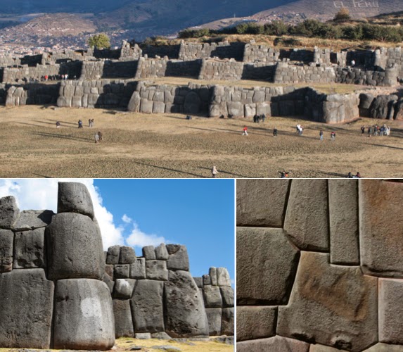
Top: The three zig-zag
walls guarding the temple site and fortress at Sacsayhuaman; Bottom Left:
Stones cut in rounded fashion to prevent anyone climbing up wall corners; Bottom
Right: Note the carved stones that fit without mortar. So perfectly cut and fit, not a knife blade or slip of paper can fit between the joints
Twelfth, while many of the
structures themselves have long been torn down, the walls still remain of these
fantastically constructed stones that weighed many tons (some hundreds of tons),
with carved corners, needing no mortar, that have withstood at least two
thousand years or more of earthquakes and upheavels. In fact, archaeologists
tell us that the walls of Sacsayhuaman rose ten feet higher than what we see
today, with that additional ten feet of stones torn down by the Spanish and used to build the
cathedrals and casas of the conquistadores.
So we ask again, “Where is the great temple tower that
Noah built, that was tall enough for him to climb up and look out over the land
and see the Lamanites in far off lands approaching?"
Using strictly the scriptures, I
would like to ask the following questions of those many Theorists who claim their pet theories about the
location of the Land of Promise are consistent with the scriptural record.
This sixteenth question is
directed to John L. Sorenson and all other Mesoamericanists who love to tell us about their Isthmus and two seas, but neglect the mention or concern themselves about the north and south seas mentioned in Helaman.
The question to ask
is quite simple and strictly scripturally based:
16. “Where are the four seas in your Mesoamerican model that Helaman tells us
existed in the Land of Promise?” (Helaman 3:8)
And the followup questions, 16A. Where is the Sea that
Divides the Land, Ether mentioned?” (Ether 10:20).
First, following a
period where there was no contention between the Nephites and Lamanites, there
began to be much contention and many dissensions (Helaman 3:3), and during this
time “there were an exceedingly great many who departed out of the land of
Zarahemla, and went forth unto the land northward to inherit the land.”
A representative Land of Promise as an island showing Helaman's four seas in the cardinal compass points mentioned in the scriptural record (Helaman 3:8), which are basically opposite one another
Second, Helaman tells
us: “And it came to pass that they
did multiply and spread, and did go forth from the land southward to the land
northward, and did spread insomuch that they began to cover the face of the
whole earth, from the sea south to the sea north, from the sea west to the sea
east“ (Helaman 3:8).
Third, this
description is in conjunction with Helaman describing how scattered throughout
the entire Land of Promise Lehi’s children had now become “from the land
Southward to the Land Northward.”
Fourth, to make sure
his future reader would understand the enormity of the Nephite accomplishments
and their expansion, Helaman adds, “But behold, a hundredth part of the
proceedings of this people, yea, the account of the Lamanites and of the
Nephites, and their wars, and contentions, and dissensions, and their
preaching, and their prophecies, and their shipping and their building of
ships, and their building of temples, and of synagogues and their sanctuaries,
and their righteousness, and their wickedness, and their murders, and their
robbings, and their plundering, and all manner of abominations and whoredoms,
cannot be contained in this work” (Helaman 3:14).
Fifth, Helaman goes
on to talk about the prosperity of the Church and the Nephite nation (Helaman
3:25).
Sixth, it is only a
side note that Helaman left us about the seas, however, it is meant to show that
the Nephites had expanded throughout the Land of Promise from “sea to shining
sea,” both from north to south and from east to west, and from this we can
understand that there were definitely four seas, one at each cardinal point of
the compass.
A representative Land of Promise with four
seas basically opposite one another in the four cardinal positions, and also
showing Ether’s sea that divides the land
Seventh, in order to
satisfy Helaman’s language, these four seas must be basically opposite one
another—from the sea north to the sea south, from the sea east to the sea
west—and be large enough to warrant them being used as terminous points to the
Nephite expansion.
Eighth, when coupled
with Jacob’s statement in 2 Nephi 10:20, that they were on an isle of the sea,
these four seas again suggest to us that the Land of Promise was an island;
however, that has been pointed out in other posts—here we are involved with the
four seas that Helaman tells us basically surrounded the Land of Promise; one in
the north, one in the east, one in the south and one in the west.
Ninth, regarding the "sea that divides the land," Ether tells us that near the narrow neck of land, there was a sea. "And they built a great city by the narrow neck of land, by the place where the sea divides the land" (Ether 10:20).
Tenth, this sea is not named, suggesting it was not seen as a different directional sea (east, south, north or west), but a locational area, i.e., this sea (or waters) divided the land.
Eleventh, and since the only division of the Land of Promise ever mentioned in all of the scriptural record is that area between the Land Northward and the Land Southward, and that the Land Southward (land of Nephi and land of Zarahemla) were "nearly surrounded by water, there being a small neck of land between the land northward and the land southward" (Alma 22:32), obviously, there was a body of water separating the Land Northward from the Land Southward, and this is that waterway Ether mentions dividing the land.
So we ask again, “Where are the four seas in your Mesoamerican model that Helaman tells us
existed in the Land of Promise?” (Helaman 3:8), and "Where is the sea that divides the land?"
Using strictly the scriptures, I
would like to ask the following questions of those many Theorists who claim their pet theories about the
location of the Land of Promise are consistent with the scriptural record.
This fifteenth question is
directed to all Theorists who claim Lehi landed in their pet model area of the
Land of Promise, and that it matches the scriptural record.
The question to ask
is quite simple and strictly scripturally based:
15. “Where is the indigenous natural cure for fever found in
the natural plants of the Land of Promise in your model as Alma tells us the
Lord provided for the Nephites?” (Alma 46:40)
Fever (Malaria) Endemic World Map,
showing in dark red those areas where spraying during outbreaks is one of the
emergency control measures to curb the spread of malaria
First, Alma tells us
that “there were some who died with fevers, which at some seasons of the year
were very frequent in the land -- but not so much so with fevers, because of
the excellent qualities of the many plants and roots which God had prepared to
remove the cause of diseases, to which men were subject by the nature of the
climate” (Alma 46:40).
Second, fever that
kills people is generally considered to be malaria, a malady brought on by
climate and the presence of standing water and Anopheles mosquito-borne parasitic protozoans (Plasmodium).
Third, malaria
remains the most significant parasitic disease of humans, with 219 million
documented cases annually, claiming over 770,000 deaths each year. The disease
is widespread in tropical and subtropical regions in a broad band around the
equator, including Sub-Sharan Africa, Asia, and the Americas.
Fourth, while there are some
preventative medications available today for people traveling where malaria exists,
during Nephite times, there was only one cure for this fever and that came from
the bark of the cinchona tree, which contains quinine. This tree, by the way,
is indigenous to, and grew only on the slopes of the Andes mountains, mainly in
Peru.
Cinchona pubescens or Quina is a genus of about eight species in the
family Rubiacaea, native to the tropical Andes forests of Western South
America. The bark of this genus is the source of a variety of alkaloids, the
most familiar of which is quinine, an anti-fever agent especially useful in
treating malaria, and known as medicinal plants
Fifth, in the early 1600s, local
Quecha Indians in Peru were seen using ground bark from a tree they called Quinquina
(“bark of barks”), a term from which the later term quinine derived. Some of
the ground bark was sent to Rome by the Jesuits to have tested against malaria.
The cure worked so effectively, that the powder became known as Jesuit Powder. Soon Europeans were
exporting the seeds and bark from the tree in such huge amounts that it became
one of Peru’s most valuable natural exports.
Left: Quecha Indians teaching Jesuits about the Cinchona tree bark who
had used the bark (right) to successfully treat shivering and fevers for a very
long time
Sixth, until the Dutch stole
some seedlings and planted them in Indonesia in the 19th century,
Andean Peru was the sole source of quinine in the world. By 1938, 80% of the
world supply came from these Indonesia cinchona farms; and since 1945, when
synthetics were developed because Japan controlled almost all the quinine in
the South Pacific during World War II, cinchona trees have become less
important.
Seventh, however, during Nephite
times and for centuries later, the cinchona tree and its bark existed only in
the Andean area of Peru where it was well known to cure fever among other maladies
by the local Indians.
So we ask again, “Where is the indigenous natural
cure for fever found in the natural plants of the Land of Promise in your model
as Alma tells us the Lord provided for the Nephites?"
Using strictly the scriptures, I
would like to ask the following questions of those many Theorists who claim their pet theories about the
location of the Land of Promise are consistent with the scriptural record.
This Fourteenth question is
directed to all Theorists who claim Lehi landed in their pet model area of the
Land of Promise, and that it matches the scriptural record.
The question to ask
is quite simple and strictly scripturally based:
14. “Where are the two unknown grains that were
planted in the City of Nephi area by Zeniff that are mentioned along with corn,
wheat and barley?”
LtoR:
Corn, Wheat, and Barley
First, Zeniff makes
it quite clear what they planted, “And we began to till the ground, yea, even
with all manner of seeds, with seeds of corn, and of wheat, and of barley, and
with neas, and with sheum, and with seeds of all manner of fruits; and we did
begin to multiply and prosper in the land” (Mosiah 9:9).
Second, it might be
assumed that when Zeniff led “as many as were desirous to go up to possess the
land,” he took with him not only people, but all the supplies that would be
needed, including seeds from Zarahemla.
Third, these seeds
grew abundantly, not just the first year, but even twelve years later, and were
a source of the Lamanites to steal their crops and “glut themselves with the
labors” of the Nephites (Mosiah 9:11-12).
Fourth, the seeds
Zeniff and his people brought from Zarahemla included two unknown grains called
Sheum and Neas—nor did Joseph Smith have any knowledge of these two grains and
was unable to label them with any known names, thus used the names from the
Nephite record.
Fifth, they must have
been important crops since they were mentioned, both by Zeniff, and later by
Mormon in his abridgement, and were likely well-known to the Nephites of the
time as well as to Mormon some 600 years later. Thus, it might be understood
that these two grains were as much stables to the Nephite diet as were corn, wheat
and barley.
Sixth, based on all
of this, it also might be assumed that these two grains had some special or
unique properties about them, such as being a healthy food staple, sturdy
growth, high nutritional value, or easily stored, etc.
Seventh, these two
grains must be located, now or during Book of Mormon times, in the Western
Hemisphere, and be able to be grown in locations where corn, wheat and barley
can be grown abundantly.
Eighth, from today’s
perspective and knowledge, there are two very important grains indigenous to
the Western Hemisphere that had a long history of several thousand years and
have re-emerged in the past two hundred years to become “the current darling of
the health food scene,” called quinoa
(referred to as the mother of all grains) and the other is kiwicha (referred to as the King’s grain), both indigenous to the
high plains of the Andes, and grown since at least 2000 B.C. in Peru, Bolivia,
Ecuador and Chile, and is referred to today as “The Miracle Grain of the
Andes,” and Global development experts call it a
“superfood “one of our most important weapons in the fight to end world
hunger.” In fact, dieticians are calling these grains the “super superfoods,”
and said to be better for you than wheat, rice and barley.
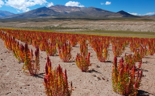
A Quinoa field in western Bolivia; Peru,
Ecuador and Chile have also seen an explosion in world popularity of quinoa in
the past six years, which has quadrupled prices at retail outlets
Ninth, quinoa (pronounced keen-wa) and kiwicha (pronounced
kee-wee-cha), have been grown in the
Andes for 4,000 years, clear up to and including the Inca Empire period, and
almost as widely used throughout the Americas as corn. After the Conquest,
however, it fell into disuse and only recently has it been reintroduced outside
the Andean area where the high plains natives lived on it for centuries.
Top: Colorful Quinoa fields; Bottom: the
Kiwicha plants. Both provide edible seeds of superior nutrition
Tenth, in all the
Western Hemisphere, there are not two other grains of any import, that would
have been unknown to Joseph Smith in 1830 that would fit the value of these two
grains planted by Zeniff along with his corn, wheat and barley, deserving
attention and repetition by Mormon. These two grains are found in Andean South
America, have grown since Jaredite times, and continually down until the time
of the Conquest, and have been revitalized in the past two hundred years to
become two of the most important grain crops in the world.
So we ask the
question again, “Where in Mesoamerica,
the Heartland, Great Lakes, Baja California, or other model, are the two
unknown grains that were planted in the City of Nephi area by Zeniff that are
mentioned along with corn, wheat and barley?"
Using strictly the scriptures, I
would like to ask the following questions of those many Theorists who claim their pet theories about the
location of the Land of Promise are consistent with the scriptural record.
This Thirteenth question is
directed mostly to John L. Sorenson, but also to all Mesoamericanists who claim
Lehi landed along the Pacific Coast of Guatemala in Mesoamerica.
The question to ask
is quite simple and strictly scripturally based:
13. “What makes you think the seeds from
Jerusalem (1 Nephi 18:24), a Mediterranean Climate, would have grown at all in
600 B.C. in Mesoamerica, along the coastal area in the vicinity of 14º north
latitude, Guatemala, which is a hot and humid tropical climate?”
First, Nephi makes it
clear that upon landing, the first thing they did was pitch their tents, then
plant their seeds they brought from Jerusalem, which produced an exceeding and
abundant crop (1 Nephi 18:24).
Second, on page 138
of Sorenson’s book, An Ancient America Setting
for the Book of Mormon, he writes: “Lehi
and his party launched their vessel into the Indian Ocean from the south coast
of the Arabian peninsula. The same winds no doubt bore them on the same sea lanes
that Arab, Chinese and Portuguese ships used later, touching India and
ultimately the Malayan peninsula. From that point Nephi’s ship likely threaded
through the islands of the western Pacific, then across the open reaches north
of the equator to landfall around 14 degrees north latitude.”
Third, 14º north
latitude is along an area of coast between the mouth of the Rio Nahualate at
the town of Nueva Venecia where highway 5 ends, and the town of El Semillero
Barra Nahualate, which is where highway 27 ends along the coast (the rest of his comment is also questionable and will be dealt with at a later time.)
Mouth of the Rio Nahualate, not far from
Lehi’s proposed landing site. This is a hot and humid tropical climate zone
where temperatures only fluctuate between 86ºF and 88ºF all year long, and certainly
not conducive to planting a crop of Mediterranean Seeds that produced an exceeding
and abundant crop (1 Nephi 18:24)
Fourth, this area is
a tropical climate zone, including tropical storms, humidity and rain. These
Guatemala lowlands have daytime temperatures reaching 100° F and nights rarely
dropping below 70° F, with temperature fairly uniform throughout the year. The
two seasons, are the dry season (summer—November through April) and the wet
season (winter—mid-May to October or November), with the coolest months (only
time to visit) in December and January.
Fifth, according to
the worldwide Permanent Agriculture Research Institute, Mediterranean Climates
are found in specific areas around the world: “western Australia, western South
Africa, the ring of countries around the Mediterranean Sea (Portugal, Spain,
southern France, Italy, Greece, Yugoslavia, Turkey, Israel, Jordan, Lebanon,
Syria, Algeria, Morocco, etc), coastal Chile, and central California. (Notice
they all have the ocean on their west, which keeps their winters mild.)
“Mediterranean” means that during a large part of the year there is little or
no rain, and since this arid condition is among those that can really benefit
from permaculture practices, it is conducive to the benefits of winter
gardening.
World climate zones with only five such
Mediterranean climates in the entire world outside the Mediterranean Sea area;
only two are in the Western Hemisphere—one in Chile (30º S. Latitude) and the
other in Central California
Sixth, climate, from
the ancient Greek klima, meaning “inclination,”
is commonly defined as the weather averaged over a long period and takes into
consideration air mass, precipitation, and temperature. In planting, climate is
one of the more important factors to be considered, and before all the modern
technology of chemical, managing and harvesting, anciently seeds grew in the
climate from which they had been grown, i.e., tropical seeds grew in tropical
climates, desert seeds grew in desert climates, subarctic seeds grew in
subarctic climates, humid subtropical seeds grew in humid subtropical climates,
highland seeds grew in highland climates, and Mediterranean seeds grew in
Mediterranean climates—there are three climate zones: tropical, temperate, and
polar; with five climate types (tropical, moderate, continental, polar, dry,
and a unnamed sixth, which is where highland climate plants survive). In
addition, these five types are broken down into 12 specific climates on the
earth, and there are numerous sub-climate conditions for planting (as an
example, a Dry Climate can be sub-divided into “dry arid,” and “dry sem-aird.”)
Every seed packet sold has a set of
instructions as to where, when, and how to plant, including pictures of local
or nation-wide planting zones so you can find the area best suited for the seeds
grown inside the packet
Seventh, even today,
seeds for flowers, fruits, vegetables, etc., are sold to be planted in specific
climates. While today, with advanced technology and knowledge, it might be
possible to grow a seed from one climate to another, in 600 B.C., that
would not have been possible. The Pilgrims found in the 17th century
that their seeds from Holland and England would not grow in Plymouth, New
England, and they would have perished as a colony except for the help of local
Indians who fed them and then helped them learn how to plant in the local soils
seeds that would grow there.
Eighth, the area at
30º South Latitude, where Lehi landed, is the only Mediterranean Climate in the
Western/Southern Hemisphere, the only other one in the Western Hemisphere is in
Central California in the Northern Hemisphere. These Mediterranean climates are classified under the
Köeppen climate classification system as “Cs”—the “C” stands for warm
temperature climates, where the average temperature of the coldest months is
64° F. The “s” stands for a dry season in the summer. In the winter the
Mediterranean climate, is mild and moist. During the summer it is very
hot and dry. The annual temperature range is between 30° and 100° F.
Ninth, coastal
Guatemala has a tropical rainforest type climate that is hot and wet all year,
with temperatures remaining in the high 80s, while Mediterranean Climates are
characterized by hot, dry summers and cool, wet winters.
Planting maize (corn) within velvetbean
mulching in the lowlands of Guatemala. Once the velvetbeans reach 8-feet in
height, the Kekchi slash the growth with machetes and chop it up into fine
mulch through which the maize grows
Tenth, wheat, barley
and other European-type grains do not grow well in Guatemala—their
principal crops are coffee, sugar, bananas, and cotton, followed by hemp,
essential oils, and cacao. By comparison, Guatemala produced 15,459,000 tons of
sugarcane compared to 1,109,000 tons of corn. But even corn, the largest
produced grain in Guatemala, reaches only about 30 bushels per acre, while by
comparison, corn in the United States averages 123 bushels per acre. Though
Guatemala is the fastest growing market for wheat in the region (importing
424,000 tons annually), Guatemala produces only about 5,000 tons of wheat
annually, and is the only wheat producer of any kind in all of Central America
region.
Eleventh, according
to the Food Security Outlook updates, Guatemala is considered a grain reserve
deficient country, with grain reserves almost constantly depleted and food
security conditions over much of the country considered either “stressed” or in
“crisis” state. Nor is it believed that current harvests will cover the food
consumption deficits of households, and food reserves dangerously low.
Twelfth, while
Sorenson claims (pg 139) that “the experience of pioneers suggests that first
success for an imported crop does not necessarily mean continued vigor for it,”
in order to claim that “flourishing plants don’t always yield good seed in
turn,” to make room for the loss of wheat and barley in his Mesoamerica Land of
Promise (where it does not particularly grow), he then finally states,” what
happened later to those plants from the seeds the Lehi party carried across
the ocean is not stated,” in order to lay claim that “by 130 B.C. “corn” (this
is maize)—a native plant of America—had become the leading crop in the land of
Nephi.” It is interesting that Nephi tells us exactly what happened to those
Jerusalem seeds, and the seeds produced by their first planting when he writes
after separating from his brothers and founding the city and land of Nephi:
“and we did prosper exceedingly; for we did sow seed, and we did reap again in
abundance” (2 Nephi 5:11). Evidentl Sorenson missed that scripture.
Coastal Guatemala near the 14º North
Latitude where Sorenson claims Lehi would have landed
Thirteenth, it is
obvious, even from Sorenson’s own writing, and all reports of Guatemala
agriculture now and anciently, that wheat and barley would not grow in
Guatemala to any degree, certainly not as Nephi tell us it did in his Land of
Promise.
Fourteenth, even after
four hundred years, wheat and barley were growing exceedingly in the Land of Promise, as was a new
crop, corn, and two other grains unknown in 1830 to Joseph Smith, called neas
and sheum (Mosiah 9:9).
So we ask again, “What makes you think the seeds from
Jerusalem (1 Nephi 18:24), a Mediterranean Climate, would have grown at all in
600 B.C. in Mesoamerica, along the coastal area in the vicinity of 14º north
latitude, Guatemala, which is a hot and humid tropical climate?"
Using strictly the scriptures, I
would like to ask the following questions of those many Theorists who claim their pet theories about the
location of the Land of Promise are consistent with the scriptural record.
This Twelfth question is
directed to John L. Sorenson, and every other Mesoamerican Theorist who claims ttheir model is the location for the Land of
Promise that matches the scriptural record.
The question to ask
is quite simple and strictly scripturally based:
12. “Where are the two animals in Mesoamerica
the Jaredites brought to, or domesticated from, those animals they brought to
the Land of Promise? (Ether 9:19).
Two
unknown animals linked with these more common beasts of burden, the horse, ass,
and elephant
First, these two
animals were so different from anything Joseph Smith, a farmer, knew or
understood and for which he had no name other than those used by the ancients,
that he could not come up with a representative name, so he simply used the
Jaredite name for them.”
Second, Moroni, in
translating Ether’s writings, names several animals, including horses, asses,
elephants, and the unknown cureloms and cumoms, which it is said were
useful to man, “and more especially the elephants and cureloms and cumoms. This
suggests that these two unknown animals were very useful to the Jaredites in
their daily living.
Third, since the
elephant is a beast of burden, it is likely these two animals would also have been, especially in light that the other two beasts of burden, the horse and ass, are
also mentioned in the same sentence.
Fourth, an elephant
provides carrying power, such as a pack animal, can be ridden, its hide is
thick and durable and is used for various clothing and materials, and its meat
eaten. Thus, these two unknown animals should also have a wide range of uses,
both living and harvested, such as food, clothing, etc.
Fifth, since we are
talking about animals dating back a few thousand years, they should have some
recognizable wild and domesticated history, as well as be or descended from
some type of animal(s) that existed 1) on the Ark, and 2) date to Mesopotamia
from which the Jaredites originated.
Sixth, these animals
should be connected to a Scientific classification recognizable within the beast
of burden classes, such as horse (Equidae),
cattle (Bovidae), elephant (Elephantidae), camel (Camelidae), etc.
Seventh, these
animals should be well known for their value to man and how ancient
civilizations, as well as present, use them for a major part of their rural
needs.
Eighth, these animals
would have been unknown in the U.S. in 1830 (Joseph Smith’s time), specifically
in the northeast where Joseph Smith lived, despite his being raised on a farm.
Ninth, by today’s
classification, these two animals should be considered indigenous to the
Western Hemisphere.
Tenth, contrary to
John L. Sorenson’s claim that the Jaredite elephants became extinct in their
day, and that the cumom and curelom were also extinct before
Moroni’s day is not founded on any comment in the scriptural record—merely an
excuse for his not knowing any current animal in Mesoamerica to match these descriptions,
especially in the case of the cumom
and curelom, for no such unknown
animal can be found anciently in Mesoamerica.
Eleventh, however, in
Andean Peru (including Chile, Bolivia and Ecuador), there are two animals that match
Ether’s description that date back thousands of years to Jaredite times and
have always existed in that area—the wild vicuna and guanaco, from which the llama
and alpaca have been domesticated. These are camelids, part of the Family Camelidae, as are all camels, and may
well have been developed from the camels known to the Jaredites anciently.
The Llamas are used as pack animals, can be
ridden, are docile, and easy to handle
Twelfth, these Andean
camelids are extremely useful to the peoples of the Andes, both anciently and
today, providing meat, wool for clothing, can be ridden, used as pack animals,
pets, guard “dogs”, easy to handle, and eat only about 5-10% of the amount of
horses, can go long periods without water, and travel long distances. While the
llama is mostly a beast of burden, the alpaca is groomed for its excellent wool
coats which are superior to sheep’s wool, with each animal producing more than
a sheep.
The Alpacas are bred for their coats of wool
as well as their meat. There are various
types of coats, thickness of wool, and color, and can be used for clothing,
blankets, coats, shoes, and numerous other items
Thirteenth, Llamas are members of the
camelid, or camel, family, and were first domesticated about 4,000 years ago in
the Andean highlands. They are hardy and well-suited to harsh environments, are
smart and easy to train. A Llama will weigh between 280 to 450 pounds and can
carry about a quarter of their body weight, so a 400-pound male llama can carry
about 100 pounds on a trek of 10 to 12 miles with no problem. They live about
20 years, are vegetarians and have efficient digestive systems. They are social
animals and prefer herds. They do not bite, but will spit when agitated. The
current population of llamas and alpacas in South America is estimated to be
more than 7 million, and there are about 158,000 llamas and 100,000 alpacas in
the U.S. and Canada today.
Fourteenth, the llama
and alpaca, though known since the late 1800s internationally, basically
continued their obscure existence until the latter part of the 20th
century, especially in the U.S. where a few llamas were not introduced until
after 1930, but in any numbers not until the 1970s. By 1980, the demand
outstripped supply and there was a two-year waiting period to obtain any llama
import. The first llama to arrive in New York was on the Dakota Ridge Farm in
1990.
So we ask again, “Where are the two animals in Mesoamerica
the Jaredites brought to, or domesticated from, those animals they brought to
the Land of Promise? (Ether 9:19).


