
I was
siting in a parking lot waiting for my wife who was clothes shopping (ugh!)
recently when a person—a Sheriff’s Deputy of all people—stopped by my open
window to chat. He pointed to my book Lehi
Never Saw Mesoamerica that was on the dash that had attracted his attention.
He was intrigued to find a fellow anti-Mesoamerica believer, and began talking
to me about his Great Lakes theory. When I commented that my book was about
South America, he asked me why I would reject the Land of Many Waters being the
Great Lakes and its drainage system, or the Finger Lakes in upstate New York.
Before I could answer, he got a call and had to leave. I’ve never seen him
again, but thought I might post this answer in case he decided to look up this
blog, which was on my card I gave him.
First of
all, the term “many waters” is found only twice in the Book of Mormon. Once in
Mosiah, where Limhi is describing the land through which his 42 man
expeditionary force to find Zarahemla traveled, in which he stated: “having traveled in a land among many
waters…” (Mosiah 8:8). However, the more understandable account of this area is
recorded by Mormon who not only knew the area well, having been born in the
Land Northward, but also fought his last battle there—knowing it well enough to
convince the Lamanite king to have their war concluded in the Land of Cumorah,
near the Hill Cumorah, which was in the land of many waters (Mormon 6:2,4).
Mormon
wrote of this place: “We did march forth to the land of Cumorah, and we did
pitch our tents around about the hill Cumorah; and it was in a land of many
waters, rivers, and fountains” (Mormon 6:4).
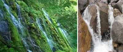 Fountains refers to the source of water, in this case, water gushing from the ground or bubbling up from underground springs
 Fountains refers to the source of water, in this case, water gushing from the ground or bubbling up from underground springs
The key
word here in conjunction with this geography is “fountains.” Obviously, “many
waters” could be any area of lakes, lagoons, loughs, ponds, or other expanse of
water. The term “rivers” is just as obviously self-explanatory. However, the
word “fountains” is often misunderstood.
In this
sense, the word fountain means some type of water source that “spurts or
cascades into the air.” More accurately, it is a spring or source of water—that
is the beginning, or head of a stream, the point of origin or dissemination of
a water flow, such as a river or water course. Clearly, the “land of many
waters” found in the Land Northward was not merely standing water, such as
large lakes claimed by the Great Lakes theorists, nor just rivers as claimed by
numerous other location theorists, but had to be an area, evidently at a high
elevation, where the water’s sources originated—an area of lakes and rivers,
but most importantly an area of springs and water sources, whether springing
out of the ground, or from melting snow, it was a location of the source of the
“many waters” found there.
It is
interesting that such a land is found in South America, in Ecuador (what would
be the Land Northward) that even on very old maps was called “Land of Many
Waters.” It might be of interest to know that this “Land of Many Waters” was
located in the “Land of Cumorah,” and by the “Hill Cumorah” (Mormon 6:4),
however, there is no such “springs or fountains” located around or near the
Hill Cumorah in upstate New York—which is about eight miles north of
Canandaigua Lake (one of the Finger Lakes, which are mostly to the east of
Cumorah) and about 20 miles south of Lake Erie. There are no springs,
fountains, or sources of water anywhere nearby.

Great Lakes watershed, showing that
water reaches Lake Erie via the Detroit River, Lake Huron, Lake Superior and
from the north Lake Nipigon and waters flowing from the north. Note that Lake
Erie is at the bottom of this watershed and nowhere around it would be
fountains or sources
Lake Erie
is fed from surrounding watersheds draining from the north, but 80% of its feed
(source) comes from the Detroit River, which is about 50 miles across the lake
to the west, and that river comes from drainage of Lake Huron from the north,
which receives its water via the St. Marys River from Lake Superior, which
itself is fed by over 200 tributaries, whose sources are hundreds of miles further
north. Consequently, though there is much water in this area, its “fountains”
originate from the northwest, north and northeast of the lake, from as far away
as the Ogoki River, north of Lake Nipigon, about 200 miles north of Lake
Superior. This would hardly be within the Land called Cumorah.
In
addition, let’s consider the moment. Mormon who was born in 310 A.D. is about
75 years old in 385 A.D. (Mormon 6:5-6) as they gathered at Cumorah. He had
been a Commanding General of the Nephite armies for most of his life since he
was sixteen (Mormon 2:2), having nearly 60 years experience commanding troops
in battle. Though he hoped to gain an advantage over the Lamanites at Cumorah
(Mormon 6:4), he knew this battle was going to be the last struggle of the
Nephites (Mormon 6:6). Still, he set his troops in order, with 23 divisions of
10,000 fighting men each (Mormon 6:11-15), or 230,000 fighting men (Mormon
6:10). In addition, these combatants had their wives and children with them
(Mormon 6:7). We do not know if the women and children fought, though it stands
to reason that probably many, if not most, did. On the other hand, being a good
general and concerned for his people, Mormon would have cosseted those unable
to fight by placing them in the rear and probably on high ground, such as in
the hills.
There
were two things he would have understood: 1) The Land of Cumorah provided room
to fight, yet held some protective benefit for him to think he might obtain an
advantage over his enemy there, and 2) He knew he could gain some safety by
retreating into much higher ground. No troop commander is going to fight a
battle if he has a choice in the area, where he has no advantage, and clearly
Mormon believed Cumorah provided that advantage since he chose that area over
any other place in the Land Northward (Mormon 6:2). The Lamanite king’s
acceptance of Cumorah suggests that he knew the size of the Nephite army he
faced, and knew he had more than sufficient troops to defeat his enemy wherever
they fought (Mormon 6:3, 8).
In
addition, we know from Mormon’s writing that the Hill Cumorah was: 1)
sufficiently high enough to see a battle field where 230,000 men, plus women
and children had fallen (at least 300,000, probably closer to 400,000), and could observe their dead bodies
(Mormon 6:11-15); and 2) it was sufficiently large and difficult to climb that
it provided protection for those who had escaped from the field of battle
(Mormon 6:11) and were not pursued. Neither of these conditions, by the way,
fits the Hill Cumorah in upstate New York, which is a small, low, rolling hill,
a mere 202 feet in height.


Del, do you have a source for the place on Ecuador maps called "the land of many waters?" Would like to see it and see where exactly it is.
ReplyDelete