 In this sense, East was at the top of the world, the direction from which the Sun rose, and where God planted the Earthly Paradise and its four great rivers “eastward In Eden.” Ezekiel wrote: “The glory of the God of Israel came from the way of the east.” The New Testament speaks of a ”star in the east” announcing Christ’s birth.
In the fourth century, father Lactantius, summed it up when he wrote: “God established two parts of the earth itself, opposite to one another and of a different character—namely, the east and the west; and of these the east is assigned to God because He Himself is the fountain of light and the enlightener of all things, and because He Himself makes you rise to eternal life. But the west is ascribed to that disturbed and depraved mind, because it conceals the light, because it always brings on darkness, and because it makes men die and perish in their sins.”
These T-O maps were used for centuries, from before the time of Christ up until the beginning of the 15th century. Over time Christian map makers saw the T not only representing bodies of water, but the very cross that Christ had died on to bring them together. The symbolism was irresistible. The three parts represented the Trinity—a whole divided into three. As the ninth-century archbishop of Mainz said, “Most appropriate is this division of the earth into three parts.” And Jerusalem not only became the spiritual but also the geometrical center of the world, and placed in the very center of all maps because of the fifth century influential Latin translation of the Bible known as the Vulgate described the center of the world in the Book of Ezekiel, as the “umbilicus terrae”—the navel of the earth.
In the Benedictine monk Matthew Paris’ time (1265 A.D.), the T-O model placed east at the top of the map, the west coast of continental Europe at the bottom left and above it, as one looks from west to east, are Germany (Alemania), the Alps, and then a thick, stubby Italy to the east and south (up and to the right) of Italy are Cyprus and Sicily, in the Mediterranean. Across the Med to the south is Africa, and to the east is Asia—on the west coast of which, occupying a lonely perch at the edge of the unknown East, is Jerusalem. Occupying the whole top portion of the map is Asia, which Matthew considered enough of a blank to fill in with notes to himself.
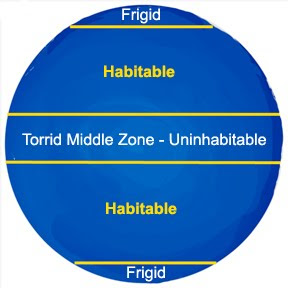
 Eventually, the earth was divided into five zones, only two of which were considered habitable—the torrid middle was too hot and the frigid poles too cold, and by the 15th century, this theory was being widely taught at European universities.
“Water does not surround the whole earth,” wrote the French theologian, astrologer, and cardinal, Pierre d’Ailly, in the early fifteenth century: “but it leaves a part of it uncovered for the habitation of animals. Since one part of the earth is less heavy and weighty than another, it is therefore higher and more elevated from the center of the world.” He then drew a map showing the earth emerging from one side of the sphere of water, and the other side deeply submerged in water, making it impossible for land to be exposed on the opposite side of the globe.
 This meant that no separate continent could possibly exist in the ocean on the other side of the world. At the same time, land in the southern hemisphere might exist—but if it did, logic dictated that it had to form a part of the same single landmass as Europe Africa, and Asia. Thus, the entire continental world, even its unknown Antipodal regions, therefore had to be contiguous.
It was this understanding that led Christopher Columbus to believe that an open waterway existed between Europe and Asia and that it could be reached by sailing west out into the Atlantic.
(See the next post, “The Fourth Part of the World.”)


No comments:
Post a Comment